
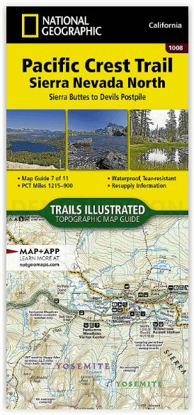
Wandelkaart 1008 Pacific Crest Trail - Nat Geo
Sierra Nevada North California
Korte omschrijving
Wandelkaart Pacific Crest Trail - Nat Geo Productomschrijving: De Pacific Crest Trail, die in de topografische kaartengids voor de Sierra Nevada North staat aangegeven, loopt door subalpiene...

Specificaties
- Uitgever: National Geographic
- ISBN-13: 9781566957908
- HOOFDCATEGORIEËN: Wandelkaart
- Activiteiten: Wandelen, Hiking & Trekking
- Regio: Californië, USA
- Land: Verenigde Staten van Amerika (USA)
- Lange afstand wandelroutes: Pacific Crest Trail (4264 km)
- Blz.: 48
- Schaal: 1:75000
- Afmeting: 10x19
- Taal: Engels
Volledige omschrijving
Wandelkaart Pacific Crest Trail - Nat Geo
Productomschrijving: De Pacific Crest Trail, die in de topografische kaartengids voor de Sierra Nevada North staat aangegeven, loopt door subalpiene bossen en vulkanische rotsformaties en blijft dicht bij de Sierra Crest. De John Muir Trail loopt 160 mijl samen met de PCT en splitst zich in het westen van de PCT bij Tuolumne Meadows in Yosemite National Park. Het wandelseizoen in de Sierra loopt meestal van half juni tot september. Zware sneeuwval kan echter al in oktober beginnen en tot begin juli aanhouden. Hoogtepunten van dit deel zijn Yosemite National Park, Devils Postpile National Monument, en Ansel Adams, Carson-Iceberg, Emigrant, Mokelumne, Hoover, Granite Chief, en Desolation wildernis gebieden.
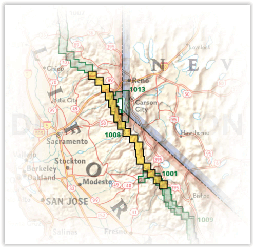
De PCT strekt zich uit over 4264 km vanaf de Canadese grens, door Washington, Oregon en Californië tot het zuidelijke eindpunt aan de Mexicaanse grens. De beroemde trail doorkruist enkele van de meest wilde en schilderachtige landschappen van het westen van de VS, waaronder 6 nationale parken, 25 nationale bossen, 48 wildernis gebieden, de vulkanische Cascade Range van de Pacific Northwest, de met sneeuw bedekte Sierra Nevada, en de Mojave en Sonoran woestijnen.
Engelse omschrijving: The Pacific Crest Trail (PCT) mapped in the Sierra Nevada North Topographic Map Guide travels through subalpine forests and volcanic rock formations, staying close to the Sierra Crest. The John Muir Trail coincides with the PCT for 160 miles, splitting west from the PCT at Tuolumne Meadows in Yosemite National Park. The high Sierra hiking season typically lasts from mid-June through September. However, heavy snow can begin as early as October and linger until early July. Highlights of this section include Yosemite National Park, Devils Postpile National Monument, and Ansel Adams, Carson-Iceberg, Emigrant, Mokelumne, Hoover, Granite Chief, and Desolation wilderness areas.
The PCT spans 2,650 miles from the Canadian border, through Washington, Oregon, and California to the southern terminus at the Mexican border. The famous trail crosses some of the most wild and scenic landscapes of the western U.S., including six national parks, 25 national forests, 48 wilderness areas, the volcanic Cascade Range of the Pacific Northwest, the snowcapped Sierra Nevada, and the Mojave and Sonoran deserts.
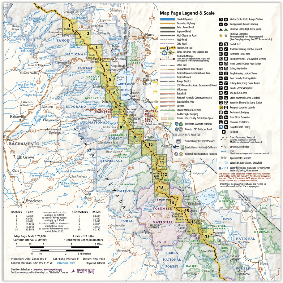
Each PCT Topographic Map Guide includes detailed topographic maps at a scale of almost 1 inch = 1 mile. Each page is centered on the PCT and overlaps with the adjacent pages so there is little chance of getting lost. Along the bottom of each page is a trail profile that shows the distance between camping areas, trailheads, and other points of interest. The map and trail profile provide a step by step visual guide to hiking the trail, mile by rugged mile. The Topographic Map Guide is built for all levels of hiking enthusiasts, from the day tripper to the multi month 'thru-hiker'. The front pages of the printed Topographic Map Guide include resupply locations, health and safety information, and much more.
More convenient and easier to use than folded maps, but just as compact and lightweight, National Geographic’s Topographic Map Guide booklets are printed on "Backcountry Tough" waterproof, tear-resistant paper with stainless steel staples. A full UTM grid is printed on the map to aid with GPS navigation.
Artikelen uit dezelfde regio

Reisgids Los Angeles- San Francisco & Las Vegas - Anwv Extra • 9789018049782
Reisgids Los Angeles- San Francisco & Las Vegas - Anwv Productomschrijving: ANWB Extra reisgids Los Angeles, San Francisco en Las Vegas - Amerika Ontdek Los Angeles, San Francisco en Las Vegas met de compleet vernieuwde reisgids ANWB Extra Los Angeles, San Francisco en Las Vegas! In deze Amerikaanse driehoek komt elke vakantieganger aan zijn trekken. De natuurliefhebber in Big Sur en d…

Reisgids California - Lonely Planet • 9781838691813
Reisgids California - Lonely Planet Productomschrijving: Van mistige Noord-Californische sequoiawouden tot zonovergoten Zuid-Californische stranden, in de betoverende Golden State lijkt Disneyland heel gewoon. Lonely Planet brengt je naar het hart van Californië, met geweldige reiservaringen en het beste planningsadvies. Lonely Planet California is je paspoort voor het meest relevante,…

Reisgids Californië - Lannoo • 9789020975130
Reisgids Californië - Lannoo Productomschrijving: De onmisbare gids voor echte trotters - "The sunshine state" letterlijk dan, want California is de wereld door en door gekend voor zijn uren zonneschijn. California heeft het letterlijk allemaal, van grote steden tot kleine dorpen, bergen, nationale en regionale parken, zee, zon & strand. Het is er wel warm, en in de zomer zelf wat aan de d…


Wandelkaart 307 Yosemite NP North West - Nat Geo • 9781566954129
Yosemite North West - Nat Geo Omvat: Emigrant Wilderness, Lake Eleanor, Stanislaus National Forest, Yosemite National Park. Engelse omschrijving: National Geographic's Trails Illustrated map of Yosemite North West- Hetch Hetchy Reservoir is designed to meet the needs of outdoor enthusiasts by combining valuable information with unmatched detail of this magnificent region of Yosemite Na…

Reisgids West Coast USA - Insight Guides ENG • 9781786718310
West Coast USA - Insight Guides Productomschrijving: Deze reisgids is een rijk geïllustreerde inspirerende versie over de westkust van de VS en een prachtig souvenir van uw reis. Perfect voor reizigers die op zoek zijn naar een diepere duik in de geschiedenis en cultuur van de bestemming en ideaal om u te inspireren en te helpen bij het plannen van uw reis. Met zijn grote selectie van…