
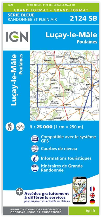
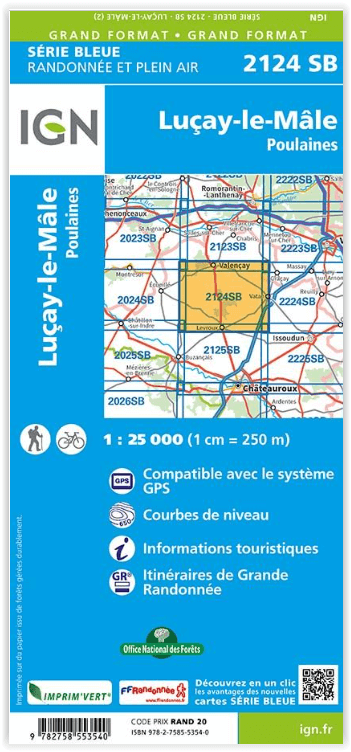
Wandelkaart 2124 SB Luçay-le-Mâle & Poulaines - IGN
Levroux- Buxeuil- Orville- La Chapelle-Saint-Laurian- Bagneux
Korte omschrijving
Wandelkaart Luçay-le-Mâle - Poulaines - IGN Productomschrijving: Luçay-le-Mâle - Poulaines zijn gemeentes in het Franse departement Indre in de regio Centre-Val de Loire. De plaats maakt dee...

Specificaties
- Uitgever: Institut Géographique National
- ISBN-13: 9782758553540
- Activiteiten: Wandelen, Hiking & Trekking
- Regio: Centre Val de Loire, Frankrijk
- Departement: Indre (36)
- Schaal: 1:25000
- Afmeting: 11x22
- Editie: 2
- Taal: Frans
Volledige omschrijving
Wandelkaart Luçay-le-Mâle - Poulaines - IGN
Productomschrijving: Luçay-le-Mâle - Poulaines zijn gemeentes in het Franse departement Indre in de regio Centre-Val de Loire. De plaats maakt deel uit van het arrondissement Châteauroux.
Omvat: Luçay-le-Mâle, Poulaines, Levroux, Buxeuil, Orville, La Chapelle-Saint-Laurian, Bagneux, Fontenay, Saint-Florentin, Bretagne, Guilly, Aize, Rouvres-les-Bois, Liniez, Moulins-sur-Céphons, Baudres, Bouges-le-Château, Poulaines, Gehée, Sougé, Vicq-sur-Nahon, Veuil.
Te ontdekken: Forêt de Gâtine, Ancienne Abbaye du Landais, Grand Labyrinthe de Napoléon,Domaine de Poulaines.
Afmeting: 96 cm x 121 cm
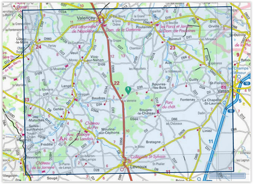
Locatie op kaart
Overzichtskaarten

IGN TOP25 Wandelkaarten Loire Centre - Zuidelijk DEEL - Bourges - Poitiers
IGN TOP25 Wandelkaarten Loire Centre - Zuidelijk DEEL - Bourges - Poitiers

Producten op de overzichtskaart
Klik op een product om naar de detailpagina te gaan.
- Wandelkaart 1627 SB Mazières-en-Gâtine & Vasles - IGN
- Wandelkaart 1725 SB Lencloître & St-Jean-de-Sauves - IGN
- Wandelkaart 1726 SB Neuville-de-Poitou & Vouillé & Mirebeau- IGN
- Wandelkaart 1727 SB Poitiers & Coulombiers - IGN
- Wandelkaart 1728 SB Vivonne & Lusignan - IGN
- Wandelkaart 1823 SB Chambray-les-Tours & Langeais - IGN
- Wandelkaart 1824 SB Ste-Maure-de-Touraine & L'Ile-Bouchard IGN
- Wandelkaart 1825 SB Châtellerault & Descartes - IGN
- Wandelkaart 1827 SB Poitiers & Chauvigny - IGN
- Wandelkaart 1923 SB Bléré- Chenonceaux & Veigné - IGN
- Wandelkaart 1925 SB Preuilly-sur-Claise & le Grand-Pressigny
- Wandelkaart 1926 SB Le Blanc- Pleumartin & La Roche-Posay - IGN
- Wandelkaart 2022 SB Montrichard & Contres - IGN
- Wandelkaart 2024 SB Châtillon-sur-Indre - Ecueillé - IGN
- Wandelkaart 2025 SB Buzançais & Mézières-en-Brenne - IGN
- Wandelkaart 2026 SB Saint-Gaultier & Rosney - IGN
- Wandelkaart 2122 SB Romorantin-Lanthenay - Cour-Cheverny - IGN
- Wandelkaart 2123 SB Selles-sur-Cher & Chabris - IGN
- Wandelkaart 2124 SB Luçay-le-Mâle & Poulaines - IGN
- Wandelkaart 2125 SB Châteauroux & Levroux - IGN
- Wandelkaart 2126 SB Le Poinçonnet- Velles & Luant - IGN
- Wandelkaart 2223 SB Vierzon & Mennetou-sur-Cher - IGN
- Wandelkaart 2224 SB Vatan & Chârost - IGN
- Wandelkaart 2225 SB Issoudun & Neuvy-Paillouxt - IGN
- Wandelkaart 2226 SB Ardentes & La Berthenoux - IGN
- Wandelkaart 2323 SB St-Martin-D'Auxigny & Foëcy - IGN
- Wandelkaart 2324 SB Bourges & Mehun-sur-Yèvre - IGN
Artikelen uit dezelfde regio

Wandelkaart 2424 SB - Nérondes & Avord - IGN • 9782758553915
Wandelkaart 2424 SB - Nérondes & Avord - IGN Productomschrijving: Nérondes & Avord zijn gemeentes in het Franse departement Cher, in de regio Centre-Val de Loire. De plaats maakt deel uit van het arrondissement Saint-Amand-Montrond. Omvat: Nérondes, Avord, Baugy, Etréchy, Annoix, Savigny-en-Septaine, Moulins-sur-Yèvre, Sainte-Solange, Farges-en-Septaine, Raymond, Villabon, Osmoy, Jussy…

Wandelkaart 2320 SB Châteauneuf-sur-Loire & Sully-sur-Loire • 9782758548539
Wandelkaart - Châteauneuf-sur-Loire & Sully-sur-Loire Productomschrijving: Châteauneuf-sur-Loire & Sully-sur-Loire zijn gemeentes in het Franse departement Loiret in de regio Centre-Val de Loire. De plaats maakt deel uit van het arrondissement Orléans. Tussen 2014 en 2018 vernieuwt IGN haar volledige collectie serie blauw. Een nieuwe toewijzing voor optimale leesbaarheid, met een grote…

Wandelkaart 2018 SB Châteaudun & Brou - IGN • 9782758537137
Wandelkaart 2018 SB - Châteaudun & Brou Productbeschrijving: Châteaudun & Brou zijn gemeentes in het Franse departement Eure-et-Loir, regio Centre. De plaats maakt deel uit van het arrondissement Châteaudun. Op korte afstand van het PNR du Perche, is dit de perfecte uitvalsbasis voor wandelaars die van bossen kunnen genieten. Tussen 2014 en 2018, worden alle SERIE BLUE kaarten in de collec…

Wandelkaart 2225 SB Issoudun & Neuvy-Paillouxt - IGN • 9782758534167
Wandelkaart 2225 SB - Issoudun & Neuvy-Paillouxt Productomschrijving: Deze topografische kaarten hebben een zeer nauwkeurige gronddetail, niet te vergeten de topografische hoogteprofielen, die het wandelen een stuk gemakkelijker maken. Issoudun is een gemeente in het Franse departement Indre (regio Centre) en telt 13.685 inwoners (1999). De plaats maakt deel uit van het arrondissement Iss…

Wandelgids Touraine centre à pied - Ed. Chamina • 9782844665928
Wandelgids - Touraine centre à pied - Ed. Chamina Productomschrijving: Het departement Indre-et-Loire komt bijna volledig overeenkomt met de voormalige provincie van Touraine. In dit Franse departement met hoge toeristische mogelijkheden is louter toe te schrijven aan de activa landschap, erfgoed en cultuur van eerste keuze. 20 wandelingen in deze gids zijn ontworpen om de toeristische sch…