
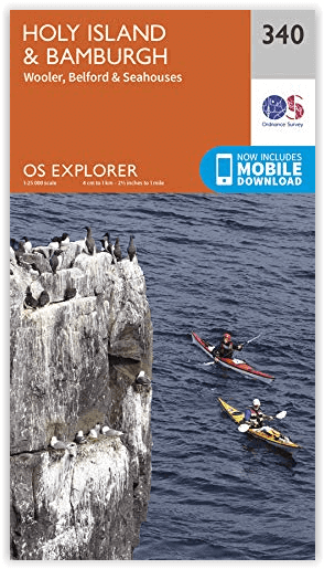
Wandelkaart 340 Holy Island & Bamburgh - OSO
Wooler - Belford - Seahouses - Holy Island - Bamburgh
Korte omschrijving
Wandelkaart Holy Island & Bamburgh - OSI Productomschrijving: Holy Island en Bamburgh zijn 2 aan de kust liggende eilanden/archipel die de interesse trekt van velen in het teken van natuur b...

Specificaties
- Uitgever: Ordnance Survey
- ISBN-13: 9780319263907
- HOOFDCATEGORIEËN: Wandelkaart
- Activiteiten: Wandelen, Hiking & Trekking
- Regio: Northumberland, Engeland
- Land: England
- AONB - Area of Outstanding Beauty: Northumberland coast AONB
- Schaal: 1:25000
- Afmeting: 13x23
- Taal: Engels
- Reeks: Explorer Series
Volledige omschrijving
Wandelkaart Holy Island & Bamburgh - OSI
Productomschrijving: Holy Island en Bamburgh zijn 2 aan de kust liggende eilanden/archipel die de interesse trekt van velen in het teken van natuur bezoek, wandelen of fietsen. De locatie is zeer mooi wat de natuur betreft.
Omvat: Cheswick, Ancroft, Haggerston, Bowsden, Beal, Fenwick; Holy Island, Holburn, Doddington, Belford, Waren Mill, Bamburgh, Seahouses, West Horton, CHatton, Warenford, Lucker, North Sunderland, Beadnell, Woolern Lilburn Tower, Chillingham, Ellingham, Nigh Newton-by-the-Sea.
Engelse omschrijving: These highly detailed maps show all the administrative boundaries, settlements as small as isolated farms, the road network down to unfenced roads and country tracks, and field boundaries (hedges and drystone walls) which make navigation across the countryside much easier. Steep gradients on roads are indicated. Various landmarks, e.g. powerlines, archaeological sites, windmills, churches and lighthouses are shown and additional graphics indicate natural terrain features such as cliffs, scree, mud and vegetation variations. The contour interval is 5 metres in the lower parts of the country and 10 metres in the uplands, and spot heights are marked. Each map covers an area of 30 x 20km (i.e. approx. 19 x 12 miles), with some double-sided maps covering more, as indicated in the individual descriptions. The maps are fully GPS compatible, with the National Grid shown at 1km intervals and latitude and longitude indicated by margin ticks at 1'.
The Explorer series has replaced the earlier, green-cover Pathfinder maps. The Explorer series is now complete and covers all of England, Wales & Scotland. Some sheets for popular areas like the National Parks are still branded as Outdoor Leisure (OL) maps, but are now included in this series as the cartography is the same as that in the Explorer Maps. The Explorer maps offer a substantial improvement on the Pathfinder series, with greater use of colour, larger area per map, and stronger emphasis on information for ramblers and tourists.
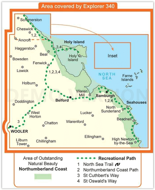
Locatie op kaart
Overzichtskaarten

OSI Explorer & Explorer Active - Zuid Scotisch Borders
OSI Explorer & Explorer Active - Zuid Scotisch Borders

Producten op de overzichtskaart
Klik op een product om naar de detailpagina te gaan.
- Wandelkaart 307 Consett & Derwent reservoir - OSI
- Wandelkaart 308 Durham & Sunderland - England - OSI
- Wandelkaart 309 Stranraer & The Rhins - Dumfries - OSI
- Wandelkaart 310 Glenluce & Kirkcowan - Schotland - OSI
- Wandelkaart 311 Wigtown- Whithorn & The Machars - OSI
- Wandelkaart 312 Kirkcudbright & Castle Douglas - OSI
- Wandelkaart 313 Dumfries & Dalbeattie- Schotland - OSI
- Wandelkaart 314 Solway Firth- Wigton & Silloth - OSI
- Wandelkaart 315 Carlisle- Brampton & Longtown - OSI
- Wandelkaart 316 Newcastle upon Tyne - Northumberland - OSI
- Wandelkaart 137 Ballantrae South Ayrshire- Schotland- OSI
- Wandelkaart 318 Galloway Forest Park North- Ayrshire
- Wandelkaart 319 Galloway Forest Park South - OSI
- Wandelkaart 320 Castle Douglas & Loch Ken - OSI
- Wandelkaart 321 Nithsdale & Dumfries & Thornhill - OSI
- Wandelkaart 322 Annandale- Dumfries & Galoway - OSI
- Wandelkaart 323 Eskdale & Castle O'er Forest- Schotland - OSI
- Wandelkaart 324 Liddesdale & Kershope Forest - OSI
- Wandelkaart 325 Morpeth & Blyth - Northumberland - OSI
- Wandelkaart 326 Ayr & Troon - South Ayrshire - OSI
- Wandelkaart 327 Cumnock & Dalmellington - OSI
- Wandelkaart 328 Sanquhar & New Cumnock - OSI
- Wandelkaart 329 Lowther Hills- Sanquhar & Leadhills - OSI
- Wandelkaart 330 Moffat & St Mary's Loch - Dumfries - OSI
- Wandelkaart 331 Teviotdale South - Schotisch Borders - OSI
- Wandelkaart 332 Alnwick Amble - Northumberland - OSI
- Wandelkaart 333 Kilmarnock & Irvine - East Ayrshire - OSI
- Wandelkaart 334 East Kilbride- Galston & Darvel - Glasgow - OSI
- Wandelkaart 335 Lanark & Tinto Hills - South Lankashire - OSI
- Wandelkaart 336 Biggar & Broughton - South Lanarkshire - OSI
- Wandelkaart 337 Peebles & Interleithen - Schotish Borders - OSI
- Wandelkaart 338 Galashiels- Selkirk & Melrose - OSI
- Wandelkaart 339 Kelso- Coldstream & Lower Tweed Valley - OSI
- Wandelkaart 340 Holy Island & Bamburgh - OSO
- Wandelkaart 341 Greenock- Largs & Millport - OSI
- Wandelkaart 342 Glasgow Schotland - OSI
- Wandelkaart 343 Motherwell & Coatbridge- Glasgow - OSI
- Wandelkaart 344 Pentland Hills RP- Edinburgh - OSI
- Wandelkaart 345 Lammermuir Hills - Edinburgh - OSI
- Wandelkaart 346 Berwick-upon-Tweed - Northumberland - OSI
- Wandelkaart 349 Falkirk- Cumbernauld & Livingston - OSI
- Wandelkaart 350 Edinburgh - East Schotland - OSI
- Wandelkaart 351 Dunbar & North Berwick - Edinburgh - OSI
- Wandelkaart 361 Isle of Arran - OSI
- Wandelkaart 362 Cowal West & Isle of Bute - OSI
- Wandelkaart OL16 Cheviot Hills Northumberland - OSI
- Wandelkaart OL42 Kielder Water & Forest - OSI
- Wandelkaart OL43 Hadrian's Wall - OSI
- Wandelkaart OL37 Cowal East- Dunoon & Iverary - OSI
- Wandelkaart OL38 Loch Lomond South & Dumbarton - OSI
Artikelen uit dezelfde regio

Wandelgids Hadrian's wall Path - Knife Edge • 9781912933075
Wandelgids - Hadrian's wall Path - Knife Edge Productomschrijving: De definitieve tweerichtingsgids voor het Hadrian's Wall Path: zowel oostwaartse als westelijke routes worden volledig beschreven. 14 verschillende routes: schema's van 3, 4, 5, 6, 7, 8 en 9 dagen voor wandelaars en hardlopers. Omvat reisroutes naar het noorden en het zuiden. De moeilijkere berekeningen van tijd, afstand en…

Wandelgids St-Cuthbert's Way Schotland - Rucksack Readers • 9781913817138
St-Cuthbert's Way Schotland - Rucksack Readers Productomschrijving: Volg in de voetsporen van St Cuthbert in deze gemakkelijke wandeling van 101 km, van Melrose Abbey in de Schotse Borders naar het Heilige Eiland Lindisfarne in Northumberland. St Cuthbert's Way is een van de Great Trails van Schotland en ook een van de Great Trails van Engeland. De route begint bij de ruïnes van Melrose Ab…

Wandelkaart XT25 Cheviot Hills - Harvey Maps • 9781851376094
Wandelkaart Cheviot Hills - Harvey Maps Productomschrijving: Ideaal voor The Cheviot, Windy Gyle en het noordelijke deel van Northumberland National Park. Omvat: Wooler, Kirk Yetholm, Breamish Valley en Harthope Valley - Lichtgewicht, gedetailleerd, duidelijk en makkelijk te lezen - Geprint op sterk, 100% watervast en scheurbestendig papier - Toont de horeca voor na je dagtrip …

Wandelgids Park Rangers Favourite Walks Northumberland - Collins • 9780008462710
Park Rangers Favourite Walks Northumberland - Collins Productomschrijving: Wandelgids voor het Northumberland National Park, met 20 van de beste routes uitgekozen door de parkwachters. Elke wandeling varieert in lengte van 2 tot 10 km en kan in minder dan 4 uur worden afgelegd. Engelse omschrijving: Walking guide to the Northumberland National Park, with 20 best routes chosen by the pa…

Wandelkaart 340 Active - Holy Island & Bamburgh - OSI • 9780319475768
Wandelkaart Holy Island & Bamburgh - Explorer Active Productomschrijving: Holy Island en Bamburgh zijn 2 aan de kust liggende eilanden/archipel die de interesse trekt van velen in het teken van natuur bezoek, wandelen of fietsen. De locatie is zeer mooi wat de natuur betreft. Omvat: Cheswick, Ancroft, Haggerston, Bowsden, Beal, Fenwick, Holy Island, Holburn, Doddington, Belford, Waren …