
Wandelkaart 361 Isle of Arran - OSI
Arran is een Brits eiland in het westen van Schotland
Korte omschrijving
Wandelkaart 361 Isle of Arran - OSI Productomschrijving: Arran is een Brits eiland in het westen van Schotland. Het behoort tot North Ayrshire. Arran wordt ook wel Schotland in het klein gen...

Specificaties
- Uitgever: Ordnance Survey
- ISBN-13: 9780319263914
- HOOFDCATEGORIEËN: Wandelkaart
- Activiteiten: Wandelen, Hiking & Trekking
- Regio: North Ayrshire Schotland
- Land: Schotland
- Regionale parken: National Scenic Area North Arran, Schotland
- Schaal: 1:25000
- Afmeting: 13x23
- Taal: Engels
- Reeks: Explorer Series
Volledige omschrijving
Wandelkaart 361 Isle of Arran - OSI
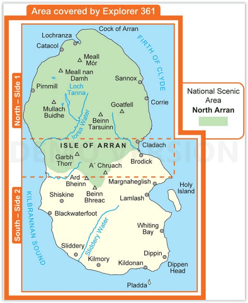
Productomschrijving: Arran is een Brits eiland in het westen van Schotland. Het behoort tot North Ayrshire. Arran wordt ook wel Schotland in het klein genoemd. Het eiland ligt in de Firth of Clyde. De belangrijkste plaats op Arran is Brodick. Het noorden van Arran heeft een aantal bergen, waaronder Goat Fell, de hoogste berg op het eiland met 874 meter.
Engelse omschrijving: These highly detailed maps show all the administrative boundaries, settlements as small as isolated farms, the road network down to unfenced roads and country tracks, and field boundaries (hedges and drystone walls) which make navigation across the countryside much easier. Steep gradients on roads are indicated. Various landmarks, e.g. powerlines, archaeological sites, windmills, churches and lighthouses are shown and additional graphics indicate natural terrain features such as cliffs, scree, mud and vegetation variations.
The contour interval is 5 metres in the lower parts of the country and 10 metres in the uplands, and spot heights are marked. Each map covers an area of 30 x 20km (i.e. approx. 19 x 12 miles), with some double-sided maps covering more, as indicated in the individual descriptions. The maps are fully GPS compatible, with the National Grid shown at 1km intervals and latitude and longitude indicated by margin ticks at 1'.
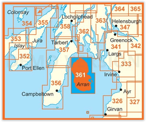
Locatie op kaart
Overzichtskaarten

OSI Explorer & Explorer Active - Zuid Scotisch Borders
OSI Explorer & Explorer Active - Zuid Scotisch Borders

Producten op de overzichtskaart
Klik op een product om naar de detailpagina te gaan.
- Wandelkaart 307 Consett & Derwent reservoir - OSI
- Wandelkaart 308 Durham & Sunderland - England - OSI
- Wandelkaart 309 Stranraer & The Rhins - Dumfries - OSI
- Wandelkaart 310 Glenluce & Kirkcowan - Schotland - OSI
- Wandelkaart 311 Wigtown- Whithorn & The Machars - OSI
- Wandelkaart 312 Kirkcudbright & Castle Douglas - OSI
- Wandelkaart 313 Dumfries & Dalbeattie- Schotland - OSI
- Wandelkaart 314 Solway Firth- Wigton & Silloth - OSI
- Wandelkaart 315 Carlisle- Brampton & Longtown - OSI
- Wandelkaart 316 Newcastle upon Tyne - Northumberland - OSI
- Wandelkaart 137 Ballantrae South Ayrshire- Schotland- OSI
- Wandelkaart 318 Galloway Forest Park North- Ayrshire
- Wandelkaart 319 Galloway Forest Park South - OSI
- Wandelkaart 320 Castle Douglas & Loch Ken - OSI
- Wandelkaart 321 Nithsdale & Dumfries & Thornhill - OSI
- Wandelkaart 322 Annandale- Dumfries & Galoway - OSI
- Wandelkaart 323 Eskdale & Castle O'er Forest- Schotland - OSI
- Wandelkaart 324 Liddesdale & Kershope Forest - OSI
- Wandelkaart 325 Morpeth & Blyth - Northumberland - OSI
- Wandelkaart 326 Ayr & Troon - South Ayrshire - OSI
- Wandelkaart 327 Cumnock & Dalmellington - OSI
- Wandelkaart 328 Sanquhar & New Cumnock - OSI
- Wandelkaart 329 Lowther Hills- Sanquhar & Leadhills - OSI
- Wandelkaart 330 Moffat & St Mary's Loch - Dumfries - OSI
- Wandelkaart 331 Teviotdale South - Schotisch Borders - OSI
- Wandelkaart 332 Alnwick Amble - Northumberland - OSI
- Wandelkaart 333 Kilmarnock & Irvine - East Ayrshire - OSI
- Wandelkaart 334 East Kilbride- Galston & Darvel - Glasgow - OSI
- Wandelkaart 335 Lanark & Tinto Hills - South Lankashire - OSI
- Wandelkaart 336 Biggar & Broughton - South Lanarkshire - OSI
- Wandelkaart 337 Peebles & Interleithen - Schotish Borders - OSI
- Wandelkaart 338 Galashiels- Selkirk & Melrose - OSI
- Wandelkaart 339 Kelso- Coldstream & Lower Tweed Valley - OSI
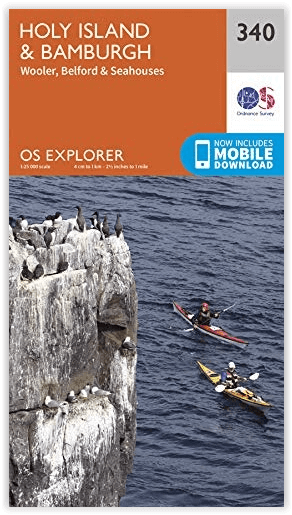
- Wandelkaart 340 Holy Island & Bamburgh - OSO
- Wandelkaart 341 Greenock- Largs & Millport - OSI
- Wandelkaart 342 Glasgow Schotland - OSI
- Wandelkaart 343 Motherwell & Coatbridge- Glasgow - OSI
- Wandelkaart 344 Pentland Hills RP- Edinburgh - OSI
- Wandelkaart 345 Lammermuir Hills - Edinburgh - OSI
- Wandelkaart 346 Berwick-upon-Tweed - Northumberland - OSI
- Wandelkaart 349 Falkirk- Cumbernauld & Livingston - OSI
- Wandelkaart 350 Edinburgh - East Schotland - OSI
- Wandelkaart 351 Dunbar & North Berwick - Edinburgh - OSI
- Wandelkaart 361 Isle of Arran - OSI
- Wandelkaart 362 Cowal West & Isle of Bute - OSI
- Wandelkaart OL16 Cheviot Hills Northumberland - OSI
- Wandelkaart OL42 Kielder Water & Forest - OSI
- Wandelkaart OL43 Hadrian's Wall - OSI
- Wandelkaart OL37 Cowal East- Dunoon & Iverary - OSI
- Wandelkaart OL38 Loch Lomond South & Dumbarton - OSI