
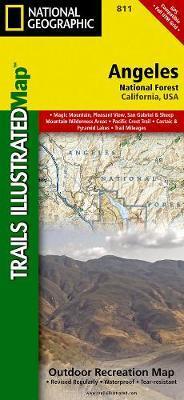
Wandelkaart 811 Angeles National Forest - Natgeo
Een bosgebied in de onmiskenbare San Gabriel Mountains
Korte omschrijving
Wandelkaart Angeles National Forest, California USA (9781566955775) National Geographic Productomschrijving: Een bosgebied in de onmiskenbare San Gabriel Mountains in het zuiden van de Ameri...

Specificaties
- Uitgever: National Geographic
- ISBN-13: 9781566955775
- HOOFDCATEGORIEËN: Wandelkaart
- Regio: Californië, USA
- Land: Verenigde Staten van Amerika (USA)
- Regionale parken: Angeles National Forest, California
- Schaal: 1:80000
- Afmeting: 10x19
- Taal: Engels
Volledige omschrijving
Wandelkaart Angeles National Forest, California USA (9781566955775) National Geographic
Productomschrijving: Een bosgebied in de onmiskenbare San Gabriel Mountains in het zuiden van de Amerikaanse staat Californië. Het bestaat uit twee delen die van elkaar gescheiden worden door de Soledad Canyon. Het Angeles National Forest reikt tot net over de grens met San Bernardino County in het oosten en Ventura County in het westen. Het hoofdkwartier van de Forest Service in het Angeles National Forest is in Arcadia.
Omschrijving uitgever: Topographic Map National Geographic's Trails Illustrated map of Angeles National Forest provides both unmatched detail and valuable information for outdoor enthusiasts enjoying this diverse recreational area just north of Los Angeles. Expertly researched and created in partnership with the U.S. Forest Service, California State Parks and others, this map features key points of interest in the forest including Magic Mountain, Pleasant View Ridge, San Gabriel, Cucamonga and Sheep Mountain Wilderness Areas; San Gabriel Mountains; Pyramid Lake; and Piru Creek Wild and Scenic River.
Also included are nearby California State Parks: Antelope Valley California Poppy Reserve, Ripley Desert Woodland, Castaic Lake State Recreation Area, Hungry Valley State Vehicular Recreation Area and Placerita Canyon. Get off the beaten path and back on again by following the map along precisely mapped trails, labeled with mileage markers and color-coded according to designated use, whether hiking, mountain biking, ATVing or horseback riding.

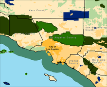
Locatie op kaart
Artikelen uit dezelfde regio

Wandelkaart 805 Tahoe Nat. Forest East - Sierra Buttes - Nat Geo • 9781566953818
Tahoe National Forest East - Sierra Buttes - Nat Geo Omvat: Donner Pass, Eldorado National Forest, Granite Chief Wilderness, Mosquito Ridge, Plumas National Forest, Sawtooth Ridge, Tahoe National Forest, Truckee. Engelse omschrijving: Expertly researched and created in partnership with the U.S. Forest Service and others, National Geographic's Trails Illustrated map of Yuba and American…

Reisgids California - Lonely Planet • 9781838691813
Reisgids California - Lonely Planet Productomschrijving: Van mistige Noord-Californische sequoiawouden tot zonovergoten Zuid-Californische stranden, in de betoverende Golden State lijkt Disneyland heel gewoon. Lonely Planet brengt je naar het hart van Californië, met geweldige reiservaringen en het beste planningsadvies. Lonely Planet California is je paspoort voor het meest relevante,…

Wandelkaart 814 Big Sur & Ventana Wilderness - Natgeo • 9781566955782
TOPO Wandelkaart 814 - Big Sur & Ventana Wilderness - Natgeo Productomschrijving: Big Sur & Ventana Wilderness California- Natgeo zijn in andere woorden, het Los Padres National Forest in het United States national forest in southern en central California. National Geographic's Trails Illustrated map of Big Sur, Ventana Wilderness combines unmatched detail with helpful information to o…

Reisgids San Diego - Top 10 - DK Eyewitness • 9780241367964
DK Eyewitness TOP 10 - San Diego California Omvat: Downtown, Old Town, Uptown, Mission Valley, Ocean Beach & Coronado. Productomschrijving: Verken de prachtige tuinen van Balboa Park, bezoek de beroemde San Diego Zoo, wandel langs de Embarcadero naar het historische tallship Star of India, of geniet van het nautische erfgoed van de stad in het Maritiem Museum. Van de Top 10 tuinen en n…

Reisgids Californië- Arizona- Nevada & Utah - Gottmer • 9789025779139
Californië- Arizona- Nevada & Utah van Gottmer Productomschrijving: Of je nu nieuwsgierig bent naar cultuurbepalende wereldsteden als San Francisco en Los Angeles dan wel je juist graag terugtrekt in de natuur: de zuidwestelijke hoek van de VS is voor iedereen een gebied vol hoogtepunten. Californië trekt het grootste aantal bezoekers, gevolgd door de Grand Canyon in Arizona, de nationale …