

Wandelgids Isle of Wight walking guide - Cicerone
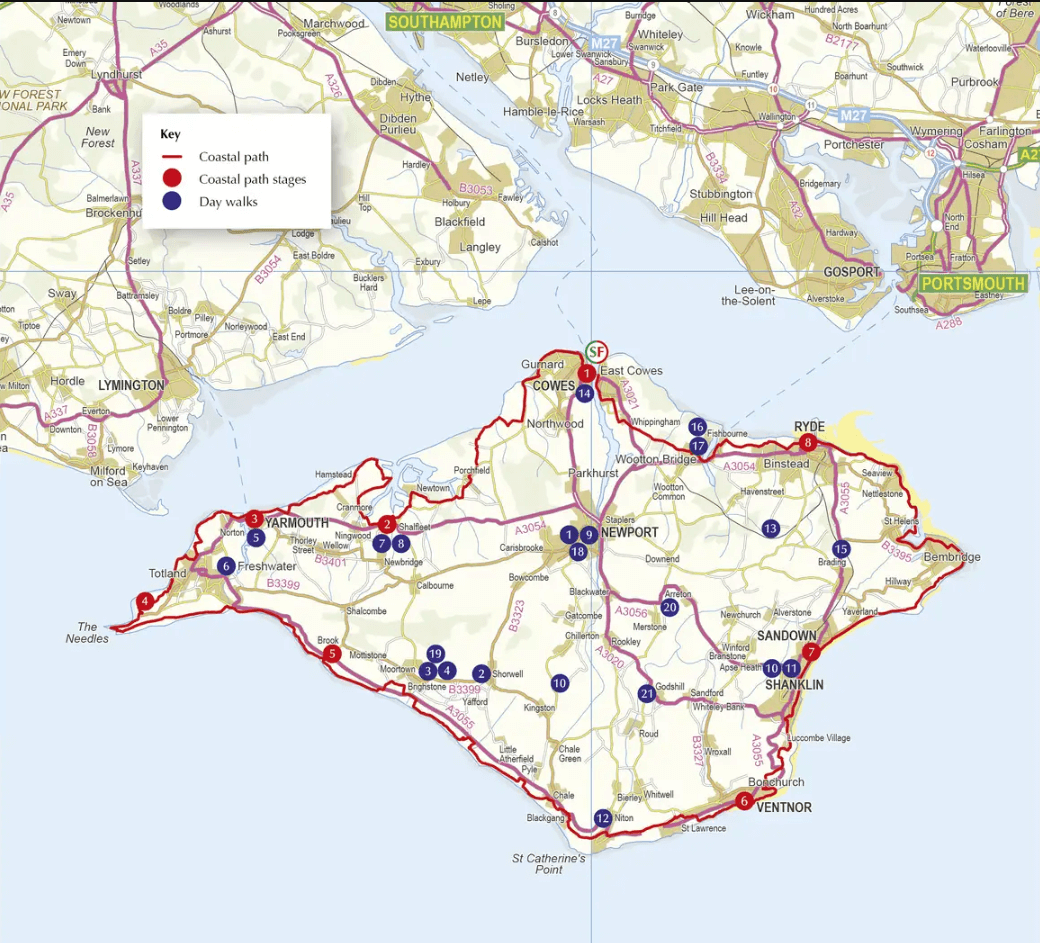
Yarmouth - Cowes - Ventnor / 33 Walking routes
Korte omschrijving
Wandelgidsen Isle of White, Engeland en South East England van CICERONE Press. Ideaal voor tochten in England.
Wandelgids Isle of Wight - Cicerone Productomschrijving: Guidebook to 33 walking routes on the beautiful Isle of Wight, from 4 to 18 miles long. The routes are suitable for all abilities and...

Specificaties
- Uitgever: CICERONE Press
- ISBN-13: 9781786312563
- HOOFDCATEGORIEËN: Wandelgids
- Activiteiten: Wandelen, Hiking & Trekking
- Auteur: Paul Curtis
- Regio: Isle of White, Engeland, South East England
- Land: England
- AONB - Area of Outstanding Beauty: Isle of Wight, AONB (half the Island)
- Editie: 3
- Taal: Engels
- De Griekse Eilanden: Isle of White
Volledige omschrijving
Wandelgids Isle of Wight - Cicerone
Productomschrijving: Guidebook to 33 walking routes on the beautiful Isle of Wight, from 4 to 18 miles long. The routes are suitable for all abilities and are accessible all year round. Includes a complete circuit of the island's spectacular coast as well as walks exploring forest trails and downland, and visiting the towns of Yarmouth, Cowes and Ventnor.
Seasons:
The climate is more temperate than on the mainland. Late spring to autumn perfect for inland walks, coastal path quite appropriate for winter (wildness, drama….) Some inland walks can be very muddy in winter.
Centres:
Sandown, Shanklin, Ventnor, Godshill, Ryde, Yarmouth, Newport.
Difficulty:
Walks graded from 'easy' up to 'moderate-strenuous'. Even children can do walks marked 'easy' (at discretion of parents) but optimum user of the book would be adult of at least average fitness. No special equipment needed for any walk.
Must See:
Magnificent and very varied Coastal Path, St Catherine's Lighthouse, constant outstanding views, dinosaur fossils on Compton Bay, red squirrels, honey-pot villages with cosy pubs, Carisbrooke Castle, Ventnor (beautiful with its own microclimate), beaches, under-explored gems like lonely Newtown Harbour... Over half the island is an Area of Outstanding National Beauty. Tennyson connection.
Artikelen uit dezelfde regio

Wandelkaart 179 Canterbury & East Kent - England - OSI • 9780319475027
Wandelkaart Canterbury- East Kent & Dover - S.E. England Productbeschrijving: Landranger kaart nummer 179 toont de Zuid-Oost kust, waaronder de kathedraal stad Canterbury, de havens van Felixstowe en Dover, evenals Margate, Hythe, Whitstable en Herne Bay. De OS Landranger kaarten reeks heeft betrekking op Groot-Brittannië met 204 gedetailleerde kaarten, perfect voor dagtochten en korte pau…

Wandelgids 094 Pathfinder guides The Isle of Wight - OS • 9780319092989
Wandelgids The Isle of Wight - OS Productomschrijving: The ISle of White is an island of the Coast of England, Het eiland wordt van Engeland gescheiden door de zeestraat de Solent. Aan de overkant ligt Southampton.

Mountainbikegids South Downs - 26 off road routes - Cicerone • 9781852846459
Mountainbikegids South Downs - 26 off road routes - Cicerone Productomschrijving: Een gids voor berg (MTB) fietsroutes op de South Downs van Hampshire en Sussex, tussen Winchester, Brighton en Eastbourne. De 26 routes beschreven in dit boek nemen deel aan achtbanen, toegewijde bos singletrack en grote afdalingen. Ritten worden gequoteerd voor alle vaardigheden met informatie over plaatseli…

Wandelkaart 165 Aylesbury & Leighton Buzzard - OSI • 9780319262634
Wandelkaart Aylesbury & Leighton Buzzard - England Productbeschrijving: Kaart nummer 165 is een all purpose kaart vol gepakt met informatie om u het gebied te helpen leren kennen. De 204 Landranger-kaarten bestrijken het land. Elke kaart heeft een oppervlakte van 40 km door 40 km (25 mijl door 25 mijl) en zoals andere kaarten van Ordnance Survey, National Grid-vierkanten worden verstrekt z…

Wandelkaart 191 Banbury Bicester & Chipping Norton- OSI • 9780319470633
Wandelkaart Banbury- Bicester & Chipping Norton England Omvat ook: Brackley. Productbeschrijving: Kaart nummer 191 in de OS Explorer kaarten reeks heeft betrekking op een gedeelte van de Cotswolds en de Macmillan Way en Wychwood way recreatieve paden. Hoogtepunten van het gebied zijn de steden van Banbury, Chipping Norton, Brackley en Bicester, en de Oxford Canal Walk. De OS Explorer k…