
Wandelgids Northern England Backpacker's - Cicerone
Noord-Engeland- Yorkshire Dales & Forest of Bowland
Korte omschrijving
Wandelgids - Northern England Backpacker's - Cicerone Productomschrijving: Een gids van 25 wandelroutes voor grote backpacker overal in Noord-Engeland van de Yorkshire Dales en het Forest of...

Specificaties
- Uitgever: CICERONE Press
- ISBN-13: 9781852843205
- HOOFDCATEGORIEËN: Wandelgids
- Activiteiten: Wandelen, Hiking & Trekking
- Auteur: Graham Uney
- Regio: Noord Engeland, North West England
- Land: England
- Blz.: 224
- Afmeting: 12x17
- Editie: 1
- Taal: Engels
Volledige omschrijving
Wandelgids - Northern England Backpacker's - Cicerone
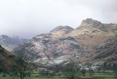
Productomschrijving: Een gids van 25 wandelroutes voor grote backpacker overal in Noord-Engeland van de Yorkshire Dales en het Forest of Bowland, het Lake District, de Pennines, en tot de Cheviots op de Schotse grens. Taaie routes te doen in een dag, maar wel goede tweedaagse uitstapjes op externe plaatsen. Een full-color gids voor 25 grote backpacking reizen over Noord-Brittannië, enkele van de beste externe hill en berglandschappen te verkennen.
Detail: Elke route is ideaal geschikt voor een weekendje weg van de drukte. De collectie van routes kan ook worden gezien als een inleiding tot de lekkernijen van backpacken, en verdere exploratie om te inspireren. Deze gids is de eerste van een reeks die betrekking hebben op de Britse eilanden. Goede kleurkaarten, routeprofielen en foto's helpen om de routes te illustreren. Met een grondige inleiding tot backpacken.
Product description: This book is geared towards those with an interest in escaping the crowds and in re-discovering the hidden corners of northern England. Twenty-vive of the region’s very best backpacking routes in remote hill and mountain landscapes are described here, and are ideally suited for a weekend away among the hills.
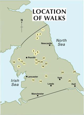
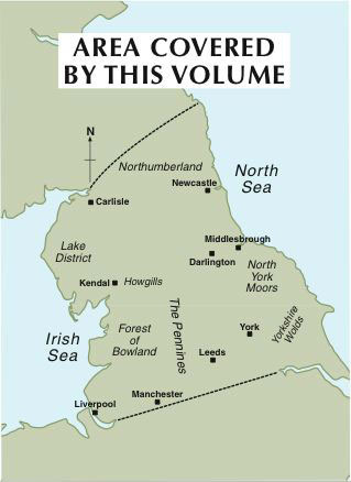
- The guide covers an area north from the Humber and Mersey to the Scottish border, taking in the Yorkshire Dales, Lake District.
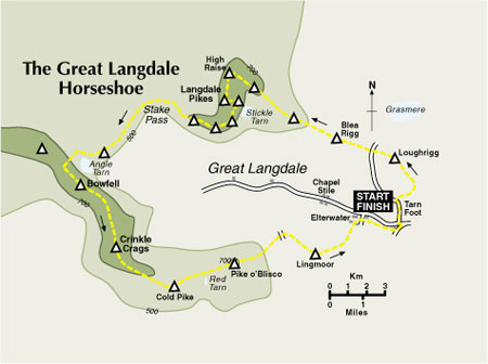
- Each walk is clearly illustrated with map, route profile and photographs.
- Most routes take two days to complete, with an overnight stop at a bothy, youth hostel or campsite.
-The guide can also be used to devise more ambitious long-day routes of 35-50km.
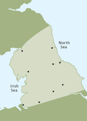
Locatie op kaart
Artikelen uit dezelfde regio

Wandelgids Silverdale & Arnside AONB - Cicerone • 9781852846282
Wandelgids - Silverdale & Arnside AONB - Cicerone Omvat: Leighton Moss, Dallam Park, Arnside Knott, Hutton Roof en Morecambe Bay Productomschrijving: Deze handige gids van 21 makkelijke dagwandelingen is gegarandeerd om u te helpen bij het verkennen van fantastische landschappen in de vorm van ruige kustpaden en betoverende bosroutes. Er zijn routes van verschillende terreinen door Le…

Wandelgids The Coast to Coast Map Booklet - Cicerone • 9781852849269
Wandelgids - The Coast to Coast Map Booklet - Cicerone Productomschrijving: Deze wandelgids toont u de 300km lange Coast to Coast Walk, een populaire interlokale trail in Noord-Engeland, die vertrekt uit St Bees Head in Cumbria naar Robin Hood's Bay aan de kust van Yorkshire. Product description: This map booklet shows the 190 mile (300km) Coast to Coast Walk, a popular long distance …

Wandelkaart Coast to Coast (west) St Bees to Keld - Harvey maps • 978185137618
Wandelkaart Coast to Coast (west) St Bees to Keld - Harvey maps Productomschrijving: Toont de gehele westelijke helft van de route op één deel van de kaart. Heeft betrekking op het gedeelte van St Bees naar Keld. Omvat alle alternatieve routes. Gedetailleerde kaart met aanvullende informatie en handige telefoonnummers, schaal van 1: 40.000. Nieuwe generatie HARVEY Superwalker, XT25 wat…

Wandelgids West Pennine Moors walking guide - Cicerone • 9781852845803
Wandelgids - West Pennine Moors walking guide - Cicerone Productomschrijving: Wandelen in de West Pennine Moors, beschrijft 30 wandelingen op het platteland rondom Blackburn, Darwen, Chorley en Bolton, de thuis van enkele van de meest inspirerende en opwindende wandelgebieden. De wandelingen variëren van korte, gemakkelijke scrambles tot meer uitdagende wandelingen die betrekking hebben op…

Wandelgids Patterdale- Lake District Fells - Cicerone • 9781786310347
Wandelgids Patterdale- Lake District Fells - Cicerone Productomschrijving: Deze gids maakt deel uit van de serie "Walking the Lake District Fells" en behandelt een breed scala aan routes naar 35 Lakeland-toppen die kunnen worden beklommen vanuit Ambleside, Grasmere en Patterdale en de valleien van Thirlmere en Ullswater, met hoogtepunten als Helvellyn en Fairfield. Suggesties voor langere …