

Wandelgids - Silverdale & Arnside AONB - Cicerone
21 dagwandelingen langs ruige kustpaden & bosroutes


Korte omschrijving
Wandelgidsen Lanacshire, England en North West England van CICERONE Press. Ideaal voor tochten in England.
Wandelgids - Silverdale & Arnside AONB - Cicerone Omvat: Leighton Moss, Dallam Park, Arnside Knott, Hutton Roof en Morecambe Bay Productomschrijving: Deze handige gids van 21 makkelijke...

Specificaties
- Uitgever: CICERONE Press
- ISBN-13: 9781852846282
- HOOFDCATEGORIEËN: Wandelgids
- Activiteiten: Wandelen, Hiking & Trekking
- Regio: Lanacshire, England, North West England
- Land: England
- AONB - Area of Outstanding Beauty: Arnside AONB, Silverdale AONB
- Editie: 2
- Taal: Engels
Volledige omschrijving
Wandelgids - Silverdale & Arnside AONB - Cicerone
Omvat: Leighton Moss, Dallam Park, Arnside Knott, Hutton Roof en Morecambe Bay
Productomschrijving: Deze handige gids van 21 makkelijke dagwandelingen is gegarandeerd om u te helpen bij het verkennen van fantastische landschappen in de vorm van ruige kustpaden en betoverende bosroutes. Er zijn routes van verschillende terreinen door Leighton Moss (RSPB centrum), Dallam Park, Arnside Knott, Hutton Roof en Morecambe Bay die geschikt zijn voor het hele gezin.
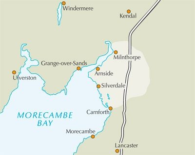
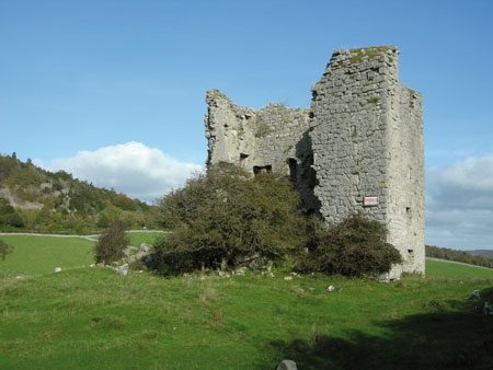
Detail: De routes in deze gids beschreven, liggen grotendeels binnen de Arnside en Silverdale ruimte die bijna het hele land ten westen van de A6 tussen Warton en Tilburg omvat. De wandelingen bieden alle attracties van de kust, bossen, weiden en heuvel waarmee het gebied zo speciaal maakt, en zijn bekwaam om bezoekers een reële appreciatie van de AONB (Areas of Outstanding Natural Beauty) te ontwikkelen. De meeste van de dagwandelingen zijn op goed aangeduide, goed vertrappelde paden geschikt voor het hele gezin.
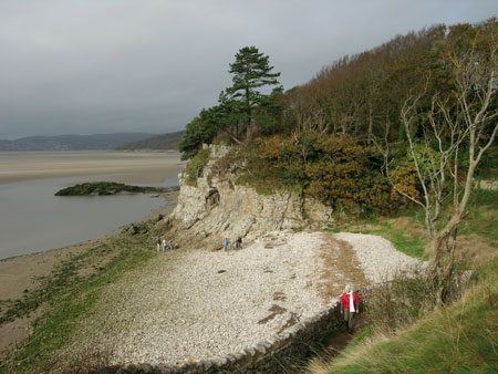
Het terrein varieert van rotsachtige en ruige kusten tot gladde kalksteen wegdekken en bosrijke paden. Scrambling langs de rotsachtige kust is moeilijker geworden sinds de ondergang van het zoute moeras en sinds er zorg moet worden genomen om te luisteren naar de inkomende stroom.
Product description: The 21 easy day walks in this book will help you explore the Silverdale and Arnside Area of Outstanding Natural Beauty, with its rugged coastal paths and enchanting woodland trails. There are routes through Leighton Moss (RSPB centre), Dallam Park, Arnside Knott, Hutton Roof and Morecambe Bay that are suitable for all abilities and every season.
Seasons:
Can be enjoyed throughout the year; spring with its abundant flowers and the colourful displays of autumn are especially rewarding; summer is the busiest time; in winter vast flocks of birds can be seen in Morecambe Bay; the woods provide sheltered walking in strong wind.
Centres:
The villages of Silverdale, Arnside and Warton have small shops; more facilities are available at Milnthorpe and Carnforth; accommodation in the area is plentiful, including hotels, guest houses, B&B and campsites.
Difficulty:
Most walks on well signed, well-trodden paths, sometimes crossing bare limestone or rough and rooty underfoot; scrambling along the rocky shore requires care to heed the incoming tide, although there are safe high tide options; walks are between 2 and 8 miles but can be easily linked into longer walks.
Must See:
The best coastal scenery and the highest concentration of woodland paths in NW England; views over Morecambe Bay and the Lakeland fells; densely wooded limestone hills rich in flora and fauna; Warton Crag, Arnside Knott, Farleton Knott, Holme Park Fell and Hutton Roof Crags; Leighton Moss RSPB reserve and several Nature Reserves.

Locatie op kaart
Overzichtskaarten

Area's of Outstanding Natural Beauty - AONB's UK
Area's of Outstanding Natural Beauty - AONB's UK

Producten op de overzichtskaart
Klik op een product om naar de detailpagina te gaan.
- Wandelgids - Guide to the Cotswolds AONB - AA
- Wandelkaart 24 - Chilterns AONB - AA
- Wandelgids - Cotswold classic walks guidebook - Goldeneye
- Wandelgids - Cotswold Classic Walks - Goldeneye
- Wandelgids - The Cotswold Way 30 classic routes - Cicerone
- Wandelgids - North Downs Way Nat. trail - Cicerone
- Wandelgids - Chilterns walking guide - Cicerone
- Wandelgids - Suffolk coast & Heaths walks - Cicerone
- Wandelgids - North Downs Way - Map Booklet - Cicerone
- Wandelgids - North Pennines AONB walking guide - Cicerone
- Wandelgids - Ridgeway National Trail - Cicerone
- Wandelgids - Forest of Bowland & Pendle - Cicerone
- Wandelgids - Hampshire's Test Way walking guide - Cicerone
- Wandelgids & Fietsgids - The Cotswold AONB - Cicerone
- Wandelgids - North Wessex Downs - Cicerone Press
- Wandelgids - Walking on the North Wessex Downs - Cicerone
- Wandelgids - Silverdale & Arnside AONB - Cicerone
- Wandelkaart OL2 - Yorkshire Dales- Southern & Western Areas - OSI
- Wandelkaart OL19 - Howgill Fells and Upper Eden Valley - OSI
- Wandelkaart OL21 - South Pennines - Yorkshire - OSI
- Wandelkaart OL31 - North Pennines- Teesdale & Weardale - OSI
- Wandelkaart OL40 - The Broads - OSI
- Wandelkaart OL41 - Forest of Bowland & Ribblesdale - OSI
- Wandelkaart OL45 - The Cotswolds AONB- Gloucestershire - OSI
- Wandelkaart 108 - Lower Tamer Valley & Plymouth- Cornwall- OSI
- Wandelkaart 115 - Exmouth & Sidmouth- Devon - OSI
- Wandelkaart 137 - Ashford- Kent downs AONB- England - OSI
- Wandelkaart 140 - Quantock Hills AONB- Somerset - OSI
- Wandelkaart 140 - Quantock Hills AONB & Bridgwater- Devon - OSI
- Wandelkaart 147 - Sevenoaks & Tonbridge- Kent - OSI
- Wandelkaart 164 - Gower AONB & Gwyr- South Wales - OSI
- Wandelkaart 164 - Gower AONB & Gwyr- Wales - OSI
- Wandelkaart 171 - Chiltern Hills West & Henley-on-Thames OSI
- Wandelkaart 171 - Chiltern Hills West AONB- Wycombe - OSI
- Wandelkaart 172 - Chiltern Hills East AONB- Wycombe - OSI
- Wandelkaart 181 - Chiltern Hills AONB North- England - OSI
- Wandelkaart 181 - Chiltern Hills North AONB- Wycombe - OSI
- Wandelkaart 190 - Malvern Hills & Bredon Hill - OSI
- Wandelkaart 190 - Malvern Hills AONB & Bredon Hill - OSI
- Wandelkaart 203 - Ludlow- Shropshire Hills AONB - OSI
- Wandelkaart 217 - Long Mynd & Wenlock Edge- Schropshire- OSI
- Wandelkaart 254 - Lleyn Peninsular East- North Wales - OSI
- Wandelkaart 261 - Boston- Lincolnshire AONB - OSI
- Wandelkaart 262 - Anglesey West- Wales AONB - OSI
- Wandelkaart 263 - Anglesey East AONB- Wales - OSI
- Wandelkaart 273 - Lincolnshire Wolds South AONB - OSI
- Wandelkaart 282 - Lincolnshire Wolds North AONB - OSI
- Wandelkaart 298 - Nidderdale AONB- Yorkshire - OSI
- Wandelkaart 298 - Nidderdale AONB North Yorkshire - OSI
- Wandelkaart 300 - Howardian Hills AONB - OSI
- Wandelkaart 300 - Howardian Hills AONB & Malton - OSI
- Wandelkaart - Mourne Mountains N. Ireland - Harvey maps
- Wandelkaart - Fietskaart Forest of Bowland - Harvey maps
- Wandelkaart XT40 - Anglesey Coastal Path N. Wales - Harvey Maps
- Wandelkaart XT40 - Pennine Way Noord - Harvey Maps
- Wandelkaart XT40 - Pennine Way Zuid - Harvey Maps
- Wandelgids Cotswold - Way Two-way trekking guide - Knife Edge
- Reisgids Cotswolds England - Rough Guides
Artikelen uit dezelfde regio

Wandelgids 15 Short Walks in Ribble Valley - Cicerone • 9781786312365
15 Short Walks in Ribble Valley - Cicerone Press Productomschrijving: Would you like to explore the best of the Ribble Valley? This guidebook covers 15 of the best short walks in the area, including Ribchester, Longridge, Dinckley, Whalley, Pendle, Clitheroe, Waddington and Downham. Why choose this guidebook? - Walks under three hours, plus one challenge route - Easy to follow w…

Wandelgids King Charles III England Coast Path - Cicerone • 9781786310279
King Charles III England Coast Path - Cicerone Productomschrijving: A guidebook to walking the northwest section of the King Charles III England Coast Path between Gretna and Chester. Covering 590km (367 miles), this straightforward trail along the Cumbria, Lancashire and Merseyside coast takes around 1 month to hike. The route is described from north to south in 28 stages between 13 a…
Wandelkaart 296 Lancaster- Morecambe & Fleetwood - OSI • 9780319471685
Wandelkaart Lancaster- Morecambe & Fleetwood - Lancaster Productbeschrijving: Kaart nummer 296 dekt Lancaster, Morecambe en Fleetwood. Hoogtepunten zijn Heysham, Lancaster Castle en Knott End-on-Sea. Omvat ook Overton en Middleton. De OS Explorer kaart voor Lancaster, Morecambe & Fleetwood is beschikbaar in zowel de standaard papieren versie als de weerbestendige 'Actief' versie. Produ…
Wandelgids 053 Pathfinder guides Lancashire NW En England - OS • 9780319091203
Wandelgids Lancashire NW En England - OS Productomschrijving: With its fen-like lowlands, its coastal scenery, the high fells of Bowland and the lush river valleys of the Ribble and Lune, Lancashire is a county of surprising diversity from its great Industrial heritage towns to its attractive, rural villages and its numerous historic monuments. There can be no better way of exploring Lanc…
Wandelgids Northern England Backpacker's - Cicerone • 9781852843205
Wandelgids - Northern England Backpacker's - Cicerone Productomschrijving: Een gids van 25 wandelroutes voor grote backpacker overal in Noord-Engeland van de Yorkshire Dales en het Forest of Bowland, het Lake District, de Pennines, en tot de Cheviots op de Schotse grens. Taaie routes te doen in een dag, maar wel goede tweedaagse uitstapjes op externe plaatsen. Een full-color gids voor 25 g…