
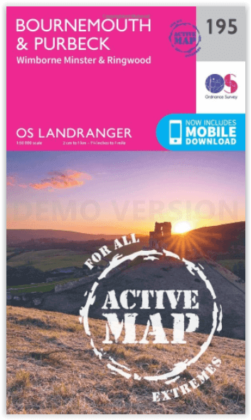
Wandelkaart 195 Bournemouth & Purbeck - OSI
Omvat de kust van Dorset- Bournemouth & Poole Bay
Korte omschrijving
Wandelkaart Bournemouth & Purbeck - S.W. England Productbeschrijving: Kaart nummer 195 in de OS Landranger kaart reeks heeft betrekking op de kust van Dorset, Bournemouth, Poole Bay, Poole H...

Specificaties
- Uitgever: Ordnance Survey
- ISBN-13: 9780319475188
- HOOFDCATEGORIEËN: Wandelkaart
- Activiteiten: Wandelen, Hiking & Trekking
- Regio: South West England
- Land: England
- Waterafstotende kaart: Ordnance Survey ACTIVE Landranger Weatherproof Maps
- UNESCO werelderfgoed: Dorset & East Devon Coast, England UK
- Schaal: 1:50000
- Afmeting: 13x23
- Taal: Engels
- Reeks: Landranger ACTIVE
Volledige omschrijving
Wandelkaart Bournemouth & Purbeck - S.W. England
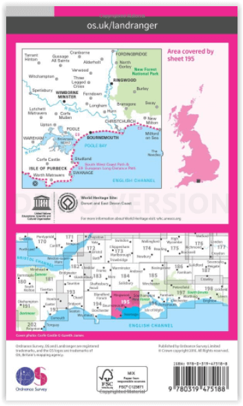
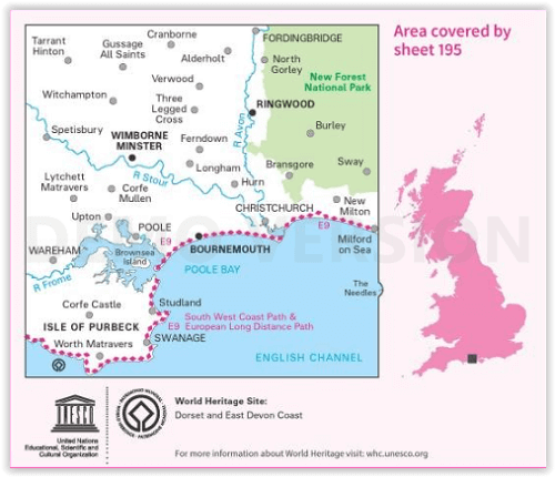
Productbeschrijving: Kaart nummer 195 in de OS Landranger kaart reeks heeft betrekking op de kust van Dorset, Bournemouth, Poole Bay, Poole Harbour, Isle van Purbeck, de Purbeck Hills, Swanage, Christchurch Bay, Ringwood, Wimborne Minster, New Milton, Milford on Sea, Wareham en Corfe Castle. Ook inbegrepen is de meeste oostelijke gedeelte van het Zuid-Westen Cast pad en het westelijke deel van het Nationaalpark New Forest NP, Sway, Burley en Fordingbridge.
De OS Landranger kaarten reeks heeft betrekking op Groot-Brittannië met 204 gedetailleerde kaarten, perfect voor dagtochten en korte pauzes. Elke kaart bevat alle informatie die u nodig heeft om dit lokaal gebied te leren kennen en omvat plaatsen van belang, toeristische informatie, picknickplaatsen en campings, plus doorgangsrechten informatie voor Engeland en Wales.
Productdiscription: Map sheet number 195 in the OS Landranger map series covers the Dorset coast, Bournemouth, Poole Bay, Poole Harbour, Isle of Purbeck, the Purbeck Hills, Swanage, Christchurch Bay, Ringwood, Wimborne Minster, New Milton, Milford on Sea, Wareham and Corfe Castle. Also included is the eastern most section of the South West Cast Path and the western area of the New Forest National Park, Sway, Burley and Fordingbridge.
The OS Landranger Map series covers Great Britain with 204 detailed maps, perfect for day trips and short breaks. Each map provides all the information you need to get to know your local area and includes places of interest, tourist information, picnic areas and camp sites, plus Rights of Way information for England and Wales.
Locatie op kaart
Gekoppelde artikelen

Wandelkaart 195 Bournemouth & Purbeck- SW England - OSI • 9780319262931
standaard versieWandelkaart Bournemouth & Purbeck - SW England Productbeschrijving: Kaart nummer 195 in de OS Landranger kaart reeks heeft betrekking op de kust van Dorset, Bournemouth, Poole Bay, Poole Harbour, Isle van Purbeck, de Purbeck Hills, Swanage, Christchurch Bay, Ringwood, Wimborne Minster, New Milton, Milford on Sea, Wareham en Corfe Castle. Ook inbegrepen is meest oostelijke gelegen gedeelte …

Wandelkaart 195 Bournemouth & Purbeck - OSI • 9780319475188
weatherproof versieWandelkaart Bournemouth & Purbeck - S.W. England Productbeschrijving: Kaart nummer 195 in de OS Landranger kaart reeks heeft betrekking op de kust van Dorset, Bournemouth, Poole Bay, Poole Harbour, Isle van Purbeck, de Purbeck Hills, Swanage, Christchurch Bay, Ringwood, Wimborne Minster, New Milton, Milford on Sea, Wareham en Corfe Castle. Ook inbegrepen is de meeste oostelijke gedeelte va…
Overzichtskaarten

OSI Landranger & Landranger Active - Zuid Engeland & London
OSI Landranger & Landranger Active - Zuid Engeland & London

Producten op de overzichtskaart
Klik op een product om naar de detailpagina te gaan.
- Wandelkaart 194 Dorchester & Weymouth- Dorset - OSI
- Wandelkaart 194 Dorchester & Weymouth- Dorset - OSI
- Wandelkaart 195 Bournemouth & Purbeck - OSI
- Wandelkaart 195 Bournemouth & Purbeck- SW England - OSI
- Wandelkaart 196 The Solent & Isle of Wight - OSI
- Wandelkaart 196 The Solent & Isle of Wight - OSI
- Wandelkaart 197 Chichester & The South Downs NP - OSI
- Wandelkaart 197 Chichester & The South Downs NP - OSI
- Wandelkaart 198 Brighton & Lewes- Sussex England - OSI
- Wandelkaart 198 Brighton & Lewes & Haywards Heath - OSI
- Wandelkaart 199 Eastbourne & Hastings- Sussex - OSI
- Wandelkaart 199 Eastbourne & Hastings- Battle - OSI
- Wandelkaart 183 Yeovil & Frome- Somerset England - OSI
- Wandelkaart 183 Yeovil & Frome- Somerset England - OSI
- Wandelkaart 184 Salisbury & The Plain- Wiltshire England - OSI
- Wandelkaart 184 Salisbury & The Plain- Wiltshire England - OSI
- Wandelkaart 185 Winchester & Basingstoke - England - OSI
- Wandelkaart 185 Winchester & Basingstoke - England - OSI
- Wandelkaart 186 Aldershot & Guildford - England - OSI
- Wandelkaart 186 Aldershot & Guildford - England - OSI
- Wandelkaart 187 Dorking & Reigate- Surrey England - OSI
- Wandelkaart 187 Dorking- Reigate & Crawley - OSI
- Wandelkaart 188 Maidstone & Royal Tunbridge Wells - OSI
- Wandelkaart 188 Maidstone & Royal Tunbridge Wells - OSI
- Wandelkaart 189 Ashford & Romney Marsh - England - OSI
- Wandelkaart 189 Ashford & Romney Marsh - Kent - OSI
- Wandelkaart 172 Bristol & Bath- S.W. England - OSI
- Wandelkaart 172 Bristol- Bath & Thornbury- S.W. England - OSI
- Wandelkaart 173 Swindon & Devizes- England - OSI
- Wandelkaart 173 Swindon- Devizes & Marlborough - OSI
- Wandelkaart 174 Newbury & Wantage- England - OSI
- Wandelkaart 174 Newbury- Wantage & Hungerford - OSI
- Wandelkaart 175 Reading & Windsor- S.E. England - OSI
- Wandelkaart 175 Reading- Windsor & Bracknell - OSI
- Wandelkaart 176 West London & Rickmansworth - OSI
- Wandelkaart 176 West London & Rickmansworth - OSI
- Wandelkaart 177 Billericay East London & Gravesend - OSI
- Wandelkaart 178 Thames Estuary & Rochester - OSI
- Wandelkaart 178 Thames Estuary- Medway London - OSI
- Wandelkaart 179 Canterbury & East Kent - England - OSI
- Wandelkaart 179 Canterbury & East Kent - England - OSI
- Wandelkaart 162 Gloucester & Forest Dean - OSI
- Wandelkaart 163 Cheltenham & Cirencester- England - OSI
- Wandelkaart 163 Cheltenham & Cirencester- England - OSI
- Wandelkaart 164 Oxford & Chipping Norton - OSI
- Wandelkaart 164 Oxford & Chipping Norton- England - OSI
- Wandelkaart 165 Aylesbury & Leighton Buzzard - OSI
- Wandelkaart 165 Aylesbury & Leighton Buzzard - OSI
- Wandelkaart 166 Luton- Hertford & Hitchin - OSI
- Wandelkaart 166 Luton- Hertford & Hitchin- Bedfordshire - OSI
- Wandelkaart 167 Chelmsford & Harlow- Essex England - OSI
- Wandelkaart 167 Chelmsford- Harlow & Bishop's - OSI
- Wandelkaart 168 Colchester- Halstead & Maldon - OSI
- Wandelkaart 168 Colchester- Halstead & Maldon- England - OSI
- Wandelkaart 169 Ipswich & The Naze- England - OSI
- Wandelkaart 169 Ipswich & The Naze- England - OSI
- Wandelkaart 149 Hereford & Leominster- England - OSI
- Wandelkaart 149 Hereford & Leominster- England - OSI
- Wandelkaart 150 Worcester & The Malverns - OSI
- Wandelkaart 150 Worcester & The Malverns- England - OSI
- Wandelkaart 151 Stratford-upon-Avon & Warwick - England - OSI
- Wandelkaart 151 Stratford-upon-Avon- England - OSI
- Wandelkaart 152 Northampton & Milton Keynes - OSI
- Wandelkaart 152 Northampton & Milton Keynes - OSI
- Wandelkaart 153 Bedford & Huntingdon- England - OSI
- Wandelkaart 153 Bedford- Huntingdon & St-Neots- England - OSI
- Wandelkaart 154 Cambridge & Newmarket - OSI
- Wandelkaart 154 Cambridge & Newmarket- England - OSI
- Wandelkaart 155 Bury St Edmunds & Stowmarket - OSI
- Wandelkaart 155 Bury St Edmunds & Sudbury - OSI
Artikelen uit dezelfde regio

Wandelkaart 172 Bristol & Bath S.W. England - OSI • 9780319262702
Wandelkaart Bristol & Bath - South West England Productbeschrijving: OS Landranger kaart 172 toont Bristol, de rivier de Avon, de Georgische stad Bath en de zuidkant van de Cotswolds way. De Romeinse badhuizen zijn het hoogtepunt van de stad, maar niet te missen zijn de diverse voorgestelde wandeltochten die wijzen naar het mooiste van de regio De OS Landranger kaarten reeks heeft betrekki…

Wandelkaart 169 Cirencester & Swindon England - OSI • 9780319470411
Wandelkaart Cirencester & Swindon- Gloucestershire Omvat ook: Fairford & Cricklade. Productbeschrijving: Kaart nummer 169 in de OS Explorer kaarten reeks heeft betrekking op een gebied van Cirencester en Fairford met een gedeelte van de Cotswolds AONB in het noorden, tot de North Wessex Downs AONB in het zuiden. De nationale routes van Thames pad en Ridgeway vallen onder deze kaart, sa…

Wandelkaart South West Coast Path 2 - Harvey maps • 9781851374274
Wandelkaart - South West Coast Path 2 - Harvey maps - Covers: The path from Bude to Portreath. Productomschrijving: Waterdichte XT40 kaart van Harvey. Een ideale kaart voor wandelaars op de langste en op één van haar meest populairste nationale routes. Het loopt langs de kust van Somerset, Cornwall en Devon, Dorset van Minehead round via Land's end naar Poole. Het omvat alle 95 mijls …

Reisgids Bath- Bristol & the S.W. pocket guide - Lonely Planet • 9781787016927
Bath & Bristol & the S.W. pocket guide - Lonely Planet Covers: Bath, Bristol, Wiltshire & Somerset Product description: Lonely Planet's Pocket Bath, Bristol & the Southwest is your passport to the most relevant, up-to-date advice on what to see and skip, and what hidden discoveries await you. Take in the beautiful views from Bath's majestic Royal Crescent, go on a street art and music …

Wandelkaart South West Coast Path 3 - Harvey maps • 9781851374328
Wandelkaart - South West Coast Path 3 - Harvey maps Productomschrijving: Waterdichte XT40 kaart van Harvey. Een ideale kaart voor wandelaars op de langste en op één van haar meest populairste nationale routes. Het loopt langs de kust van Somerset, Cornwall en Devon, Dorset van Minehead round via Land's end naar Poole. Het omvat alle 95 mijls van het World Heritage site bekend als de Jurass…