

Wandelkaart 153 Bedford & Huntingdon- England - OSI
Omvat de oude steden van Bedford- Huntingdon & St Neots
Korte omschrijving
Wandelkaarten Engeland en Bedfordshire, England van Ordnance Survey. Ideaal voor tochten in England.
Wandelkaart Bedford & Huntingdon - Bedfordshire England Productbeschrijving: De oude steden van Bedford, Huntingdon en St Neots liggen allemaal aan de oevers van de Great Ouse - die op deze ...

Specificaties
- Uitgever: Ordnance Survey
- ISBN-13: 9780319474761
- HOOFDCATEGORIEËN: Wandelkaart
- Activiteiten: Wandelen, Hiking & Trekking
- Regio: Bedfordshire, England, Engeland
- Land: England
- Waterafstotende kaart: Ordnance Survey ACTIVE Landranger Weatherproof Maps
- TOPO's & Stafkaarten: Topografisch wandelen
- Schaal: 1:50000
- Taal: Engels
- Reeks/Serie: Landranger ACTIVE series OSI
Volledige omschrijving
Wandelkaart Bedford & Huntingdon - Bedfordshire England
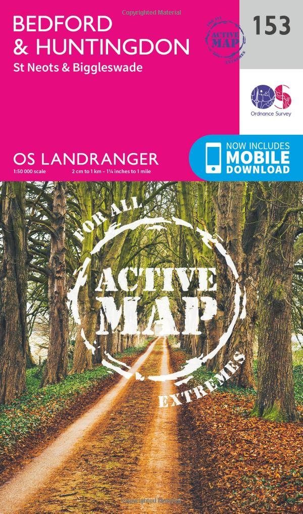
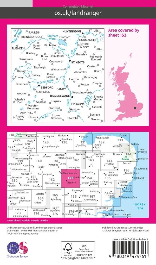
Productbeschrijving: De oude steden van Bedford, Huntingdon en St Neots liggen allemaal aan de oevers van de Great Ouse - die op deze OS Landranger 153 kaart verschijnen. De belangrijkste bezienswaardigheden van Bedford omvatten St Paul's Church en Bedford Park. Huntingdon, als geboorteplaats van Oliver Cromwell is een historische stad, St Neots en Biggleswade gelegen ten zuiden.
De OS Landranger kaarten reeks heeft betrekking op Groot-Brittannië met 204 gedetailleerde kaarten, perfect voor dagtochten en korte pauzes. Elke kaart bevat alle informatie die u nodig heeft om dit lokaal gebied te leren kennen en omvat plaatsen van belang, toeristische informatie, picknickplaatsen en campings, plus doorgangsrechten informatie voor Engeland en Wales.
Productdiscription: The old towns of Bedford, Huntingdon and St Neots are all situated on the banks of the River Great Ouse - and appear on OS Landranger map 153. The main attractions of Bedford include St Paul's Church and Bedford Park. Huntingdon, as the birthplace of Oliver Cromwell, is a historical town with St Neots and Biggleswade located to the south.
The OS Landranger Map series covers Great Britain with 204 detailed maps, perfect for day trips and short breaks. Each map provides all the information you need to get to know your local area and includes places of interest, tourist information, picnic areas and camp sites, plus Rights of Way information for England and Wales.
Locatie op kaart
Gekoppelde artikelen

Wandelkaart 153 Bedford- Huntingdon & St-Neots- England - OSI • 9780319262511
standaard versieWandelkaart Bedford- Huntingdon & St-Neots - England Productbeschrijving: De oude steden van Bedford, Huntingdon en St Neots liggen allemaal aan de oevers van de Great Ouse - en verschijnen op kaart OS Landranger 153. De belangrijkste bezienswaardigheden van Bedford omvatten St Paul's Church en Bedford Park. Huntingdon, als geboorteplaats van Oliver Cromwell, is een historische stad St Neo…

Wandelkaart 153 Bedford & Huntingdon- England - OSI • 9780319474761
weatherproof versieWandelkaart Bedford & Huntingdon - Bedfordshire England Productbeschrijving: De oude steden van Bedford, Huntingdon en St Neots liggen allemaal aan de oevers van de Great Ouse - die op deze OS Landranger 153 kaart verschijnen. De belangrijkste bezienswaardigheden van Bedford omvatten St Paul's Church en Bedford Park. Huntingdon, als geboorteplaats van Oliver Cromwell is een historische sta…
Overzichtskaarten

OSI Landranger & Landranger Active - Zuid Engeland & London
OSI Landranger & Landranger Active - Zuid Engeland & London

Producten op de overzichtskaart
Klik op een product om naar de detailpagina te gaan.
- Wandelkaart 194 Dorchester & Weymouth- Dorset - OSI
- Wandelkaart 194 Dorchester & Weymouth- Dorset - OSI
- Wandelkaart 195 Bournemouth & Purbeck - OSI
- Wandelkaart 195 Bournemouth & Purbeck- SW England - OSI
- Wandelkaart 196 The Solent & Isle of Wight - OSI
- Wandelkaart 196 The Solent & Isle of Wight - OSI
- Wandelkaart 197 Chichester & The South Downs NP - OSI
- Wandelkaart 197 Chichester & The South Downs NP - OSI
- Wandelkaart 198 Brighton & Lewes- Sussex England - OSI
- Wandelkaart 198 Brighton & Lewes & Haywards Heath - OSI
- Wandelkaart 199 Eastbourne & Hastings- Sussex - OSI
- Wandelkaart 199 Eastbourne & Hastings- Battle - OSI
- Wandelkaart 183 Yeovil & Frome- Somerset England - OSI
- Wandelkaart 183 Yeovil & Frome- Somerset England - OSI
- Wandelkaart 184 Salisbury & The Plain- Wiltshire England - OSI
- Wandelkaart 184 Salisbury & The Plain- Wiltshire England - OSI
- Wandelkaart 185 Winchester & Basingstoke - England - OSI
- Wandelkaart 185 Winchester & Basingstoke - England - OSI
- Wandelkaart 186 Aldershot & Guildford - England - OSI
- Wandelkaart 186 Aldershot & Guildford - England - OSI
- Wandelkaart 187 Dorking & Reigate- Surrey England - OSI
- Wandelkaart 187 Dorking- Reigate & Crawley - OSI
- Wandelkaart 188 Maidstone & Royal Tunbridge Wells - OSI
- Wandelkaart 188 Maidstone & Royal Tunbridge Wells - OSI
- Wandelkaart 189 Ashford & Romney Marsh - England - OSI
- Wandelkaart 189 Ashford & Romney Marsh - Kent - OSI
- Wandelkaart 172 Bristol & Bath- S.W. England - OSI
- Wandelkaart 172 Bristol- Bath & Thornbury- S.W. England - OSI
- Wandelkaart 173 Swindon & Devizes- England - OSI
- Wandelkaart 173 Swindon- Devizes & Marlborough - OSI
- Wandelkaart 174 Newbury & Wantage- England - OSI
- Wandelkaart 174 Newbury- Wantage & Hungerford - OSI
- Wandelkaart 175 Reading & Windsor- S.E. England - OSI
- Wandelkaart 175 Reading- Windsor & Bracknell - OSI
- Wandelkaart 176 West London & Rickmansworth - OSI
- Wandelkaart 176 West London & Rickmansworth - OSI
- Wandelkaart 177 Billericay East London & Gravesend - OSI
- Wandelkaart 178 Thames Estuary & Rochester - OSI
- Wandelkaart 178 Thames Estuary- Medway London - OSI
- Wandelkaart 179 Canterbury & East Kent - England - OSI
- Wandelkaart 179 Canterbury & East Kent - England - OSI
- Wandelkaart 162 Gloucester & Forest Dean - OSI
- Wandelkaart 163 Cheltenham & Cirencester- England - OSI
- Wandelkaart 163 Cheltenham & Cirencester- England - OSI
- Wandelkaart 164 Oxford & Chipping Norton - OSI
- Wandelkaart 164 Oxford & Chipping Norton- England - OSI
- Wandelkaart 165 Aylesbury & Leighton Buzzard - OSI
- Wandelkaart 165 Aylesbury & Leighton Buzzard - OSI
- Wandelkaart 166 Luton- Hertford & Hitchin - OSI
- Wandelkaart 166 Luton- Hertford & Hitchin- Bedfordshire - OSI
- Wandelkaart 167 Chelmsford & Harlow- Essex England - OSI
- Wandelkaart 167 Chelmsford- Harlow & Bishop's - OSI
- Wandelkaart 168 Colchester- Halstead & Maldon - OSI
- Wandelkaart 168 Colchester- Halstead & Maldon- England - OSI
- Wandelkaart 169 Ipswich & The Naze- England - OSI
- Wandelkaart 169 Ipswich & The Naze- England - OSI
- Wandelkaart 149 Hereford & Leominster- England - OSI
- Wandelkaart 149 Hereford & Leominster- England - OSI
- Wandelkaart 150 Worcester & The Malverns - OSI
- Wandelkaart 150 Worcester & The Malverns- England - OSI
- Wandelkaart 151 Stratford-upon-Avon & Warwick - England - OSI
- Wandelkaart 151 Stratford-upon-Avon- England - OSI
- Wandelkaart 152 Northampton & Milton Keynes - OSI
- Wandelkaart 152 Northampton & Milton Keynes - OSI
- Wandelkaart 153 Bedford & Huntingdon- England - OSI
- Wandelkaart 153 Bedford- Huntingdon & St-Neots- England - OSI
- Wandelkaart 154 Cambridge & Newmarket - OSI
- Wandelkaart 154 Cambridge & Newmarket- England - OSI
- Wandelkaart 155 Bury St Edmunds & Stowmarket - OSI
- Wandelkaart 155 Bury St Edmunds & Sudbury - OSI

OSI Landranger & Landranger Active - Midden Engeland - Midland's
OSI Landranger & Landranger Active - Midden Engeland - Midland's

Producten op de overzichtskaart
Klik op een product om naar de detailpagina te gaan.
- Wandelkaart 102 Preston & Blackpool- Lancashire - OSI
- Wandelkaart 102 Preston & Blackpool- Lytham - OSI
- Wandelkaart 103 Blackburn & Burnley- N.W. England - OSI
- Wandelkaart 103 Blackburn- Burnley & Clitheroe - OSI
- Wandelkaart 104 Leeds & Bradford & Harrogate - OSI
- Wandelkaart 104 Leeds & Bradford - West Yorkshire - OSI
- Wandelkaart 105 York & Selby- North Yorkshire - OSI
- Wandelkaart 105 York & Selby- North Yorkshire - OSI
- Wandelkaart 106 Market Weighton- East Riding of Yorkshire - OSI
- Wandelkaart 106 Market Weighton- Goole- England - OSI
- Wandelkaart 107 Kingston upon Hull- Beverley - OSI
- Wandelkaart 107 Kingston upon Hull- Yorkshire - OSI
- Wandelkaart 108 Liverpool & Southport - England - OSI
- Wandelkaart 108 Liverpool & Merseyside - England - OSI
- Wandelkaart 109 Greater Manchester England - OSI
- Wandelkaart 109 Manchester- Bolton & Warrington - OSI
- Wandelkaart 110 Sheffield & Huddersfield - Glossop - OSI
- Wandelkaart 110 Sheffield & Huddersfield - Yorkshire - OSI
- Wandelkaart 111 Sheffield & Doncaster- Rotherham - OSI
- Wandelkaart 111 Sheffield & Doncaster England - OSI
- Wandelkaart 112 Scunthorpe & Gainsborough - OSI
- Wandelkaart 112 Scunthorpe & Gainsborough - OSI
- Wandelkaart 113 Grimsby- Louth & Market Rasen - OSI
- Wandelkaart 113 Grimsby- North East Lincolnshire - OSI
- Wandelkaart 114 Anglesey & Ynys Môn- N.W. Wales - OSI
- Wandelkaart 114 Anglesey- North West Wales - OSI
- Wandelkaart 115 Snowdon & Caernarfon- Snowdonia NP - OSI
- Wandelkaart 115 Snowdon & Yr Wyddfa - Snowdonia NP - OSI
- Wandelkaart 116 Denbigh & Colwyn Bay - North Wales - OSI
- Wandelkaart 116 Denbigh & Colwyn Bay - North Wales - OSI
- Wandelkaart 117 Chester & Wrexham - Ellesmere Port - OSI
- Wandelkaart 117 Chester & Wrexham - West Cheshire - OSI
- Wandelkaart 118 Stoke-on-Trent & Macclesfield - OSI
- Wandelkaart 118 Stoke-on-Trent & Macclesfield - OSI
- Wandelkaart 119 Buxton & Matlock- Derbyshire - OSI
- Wandelkaart 119 Buxton- Matlock & Chesterfield - OSI
- Wandelkaart 120 Mansfield & Sherwood Forest - OSI
- Wandelkaart 120 Mansfield - Nottinghamshire - OSI
- Wandelkaart 121 Lincoln & Newark-on-Trent- England - OSI
- Wandelkaart 121 Lincoln & Newark-on-Trent- England - OSI
- Wandelkaart 122 Skegness & Horncastle - England - OSI
- Wandelkaart 122 Skegness & Horncastle - England - OSI
- Wandelkaart 123 Lleyn Peninsula - North Wales - OSI
- Wandelkaart 123 Lleyn Peninsula - North Wales - OSI
- Wandelkaart 124 Porthmadog & Dolgellau - N. Wales - OSI
- Wandelkaart 124 Porthmadog & Dolgellau - N. Wales - OSI
- Wandelkaart 125 Bala & Lake Vyrnwy- Gwynedd - OSI
- Wandelkaart 125 Bala & Lake Vyrnwy- N. Wales - OSI
- Wandelkaart 126 Shrewsbury & Oswestry - England - OSI
- Wandelkaart 126 Shrewsbury & Oswestry - England - OSI
- Wandelkaart 127 Stafford & Telford - Ironbridge England - OSI
- Wandelkaart 127 Stafford & Telford - Staffordshire England - OSI
- Wandelkaart 128 Derby & Burton upon Trent - England - OSI
- Wandelkaart 128 Derby & Burton upon Trent - England - OSI
- Wandelkaart 129 Nottingham & Loughborough - England - OSI
- Wandelkaart 129 Nottingham & Loughborough - England - OSI
- Wandelkaart 130 Grantham- Lincolnshire- England - OSI
- Wandelkaart 130 Grantham- Sleaford & Bourne - OSI
- Wandelkaart 131 Boston & Spalding - England - OSI
- Wandelkaart 131 Boston & Spalding - Lincolshire England - OSI
- Wandelkaart 132 King's Lynn & Fakenham - England - OSI
- Wandelkaart 133 North East Norfolk - OSI
- Wandelkaart 133 North East Norfolk - Cromer - Wroxham - OSI
- Wandelkaart 134 Norwich & The Broads NP - OSI
- Wandelkaart 134 Norwich- The Broads NP & Great Yarmouth - OSI
- Wandelkaart 135 Aberystwyth & Machynlleth Wales - OSI
- Wandelkaart 135 Aberystwyth & Machynlleth Wales - OSI
- Wandelkaart 137 Ludlow & Church Stretton - England - OSI
- Wandelkaart 137 Ludlow & Church Stretton - England - OSI
- Wandelkaart 138 Kidderminster & Wyre Forest - OSI
- Wandelkaart 138 Kidderminster & Wyre Forest - OSI
- Wandelkaart 139 Birmingham & Wolverhampton - OSI
- Wandelkaart 139 Birmingham & Wolverhampton - OSI
- Wandelkaart 140 Leicester- Coventry & Rugby - OSI
- Wandelkaart 140 Leicester- Coventry & Rugby - OSI
- Wandelkaart 140 Kettering & Corby- England - OSI
- Wandelkaart 141 Kettering & Corby- England - OSI
- Wandelkaart 142 Peterborough & Market Deeping - England
- Wandelkaart 142 Peterborough & Market Deeping- England
- Wandelkaart 143 Ely & Wisbech- Cambridgeshire - OSI
- Wandelkaart 143 Ely- Wisbech & Downham - OSI
- Wandelkaart 144 Thetford & Breckland- Norfolk - OSI
- Wandelkaart 144 Thetford- Breckland & Wymondham - OSI
- Wandelkaart 145 Cardigan & Mynydd Preseli - OSI
- Wandelkaart 145 Cardigan & Mynydd Preseli - OSI
- Wandelkaart 146 Lampeter & Llandovery - Ceredigion - OSI
- Wandelkaart 146 Lampeter & Llandovery - Ceredigion - OSI
- Wandelkaart 147 Elan Valley & Builth Wells - Wales - OSI
- Wandelkaart 147 Elan valley & Builth Wells - Wales - OSI
- Wandelkaart 148 Presteigne & Hay-on-Wye - S. Wales - OSI
- Wandelkaart 148 Presteigne & Hay-on-Wye - S. Wales - OSI
- Wandelkaart 149 Hereford & Leominster - England - OSI
- Wandelkaart 149 Hereford & Leominster - England - OSI
- Wandelkaart 150 Worcester & The Malverns - England - OSI
- Wandelkaart 150 Worcester & The Malverns - England - OSI
- Wandelkaart 151 Stratford-upon-Avon & Warwick - OSI
- Wandelkaart 151 Stratford-upon-Avon- England - OSI
- Wandelkaart 152 Northampton & Milton Keynes - OSI
- Wandelkaart 152 Northampton & Milton Keynes - OSI
- Wandelkaart 153 Bedford & Huntingdon- England - OSI
- Wandelkaart 153 Bedford- Huntingdon & St-Neots - OSI
- Wandelkaart 154 Cambridge & Newmarket - England - OSI
- Wandelkaart 154 Cambridge & Newmarket - England - OSI
- Wandelkaart 155 Bury St-Edmunds & Stowmarket - OSI
- Wandelkaart 155 Bury St-Edmunds & Sudbury - OSI
- Wandelkaart 156 Saxmundham & Aldeburgh - OSI
- Wandelkaart 156 Saxmundham- Aldeburgh & Southwold - OSI
- Wandelkaart 157 St-David's & Haverfordwest - Wales - OSI
- Wandelkaart 157 St-David's & Haverfordwest - Wales - OSI
- Wandelkaart 158 Tenby & Pembroke - Wales - OSI
- Wandelkaart 158 Tenby & Pembroke - Wales - OSI
- Wandelkaart 159 Swansea & Gower - South Wales - OSI
- Wandelkaart 159 Swansea- Gower & Carmarthen - OSI
- Wandelkaart 160 Brecon Beacons NP - Powys Wales - OSI
- Wandelkaart 160 Brecon Beacons NP - Powys Wales - OSI
- Wandelkaart 161 Black Mountains & Brecon Beacons NP - OSI
- Wandelkaart 161 Black Mountains & Brecon Beacons NP - OSI
- Wandelkaart 162 Gloucester & Forest of Dean - OSI
- Wandelkaart 163 Cheltenham & Cirencester - England - OSI
- Wandelkaart 163 Cheltenham & Cirencester - England - OSI
- Wandelkaart 164 Oxford & Chipping Norton - England - OSI
- Wandelkaart 164 Oxford & Chipping Norton - England - OSI
- Wandelkaart 165 Aylesbury & Leighton Buzzard - OSI
- Wandelkaart 165 Aylesbury & Leighton Buzzard - OSI
- Wandelkaart 166 Luton- Hertford & Hitchin - OSI
- Wandelkaart 166 Luton- Hertford & Hitchin- Bedfordshire - OSI
- Wandelkaart 167 Chelmsford & Harlow- Essex England - OSI
- Wandelkaart 167 Chelmsford- Harlow & Bishop's - OSI
- Wandelkaart 168 Colchester- Halstead & Maldon - OSI
- Wandelkaart 168 Colchester- Halstead & Maldon- England - OSI
- Wandelkaart 169 Ipswich & The Naze- England - OSI
- Wandelkaart 169 Ipswich & The Naze- England - OSI
Artikelen uit dezelfde regio

Plano Wandkaart Engeland & Wales 76 x 92 cm - Nat Geo • 9781597754880
Wandkaart Engeland & Wales 76 x 92 cm - Nat Geo Productomschrijving: National Geographic's Classic style wall map of England and Wales (Cymru) provides exceptional detail of two of the three regions that make up the island of Great Britain. The map features a bright color palette with blue oceans and terrain detailed in stunning shaded relief that has been a hallmark of National Geographic…

Wandelgids Walk Britain - Vertebrate Publishing • 9781839811449
Wandelgids Walk Britain - Vertebrate Productomschrijving: 90 inspirational car-free walks in England, Scotland and Wales Walk Britain by Elise Downing is an inspirational collection of 90 walking routes accessible by public transport which can enable you to see the best of Great Britain in an environmentally friendly way. The book is organised into easily accessible base locations thr…

Landkaart Wegenkaart 3 Zuid Oost Engeland - AA • 9780749584085
Wegenkaart Zuid Oost Engeland - AA Productomschrijving: AA Road Map South East England is a practical and slimline, foldable map from the experts at the AA. Encased in a durable, weatherproof cover, the mapping is produced at a scale of 3 miles to 1 inch (1:200,000 / 2km to 1cm) combining clear design, an easy-to-read scale and more road detail to ensure that you never lose your way. …

Wegenatlas Road Atlas Britain 2025 - AA Publishing • 9780749584009
Road Atlas Britain 2025 - AA Publishing Productomschrijving: This top-selling road atlas showcases Britain’s clearest mapping from the experts at the AA. Each page has been titled with its geographical location so you can turn to the page you need more easily. Wide and narrow minor roads, National Trust, English and World Heritage sites and hard-to-find places are shown. There are 112 cit…

Plano Postcode Wandkaart Groot-Brittannië 84 x 119 - Lovell Johns • 9781910378977
Wandkaart Groot-Brittannië 84 x 119 - Lovell Johns Productomschrijving: De Postcodegebieden van de Britse eilanden worden duidelijk weergegeven en het gebied Groot-Londen wordt uitgebreid om deze postcodegebieden duidelijk te tonen. Bevat informatie, inclusief stads-, provincie- en districtsnamen. Steden zijn gemarkeerd om de geschatte populatie te tonen. Gebruik van de kaart: de postc…