

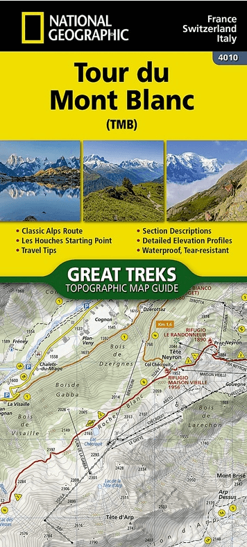
Wandelkaart 4010 Tour du Mont Blanc - Nat Geo
Tussen Aosta Valley and Haute-Savoie - Mont Blanc

Korte omschrijving
Wandelkaarten Auvergne-Rhône-Alpes, Frankrijk van National Geographic. Ideaal voor tochten in Frankrijk, Italië en Zwitserland.
Wandelkaart Tour du Mont Blanc - Nat Geo Productomschrijving: Located in the northwestern Alps, between the Aosta Valley and Haute-Savoie, Mont Blanc is the highest mountain in Europe at 4,8...

Specificaties
- Uitgever: National Geographic
- ISBN-13: 9781566959544
- HOOFDCATEGORIEËN: Wandelkaart
- Activiteiten: Wandelen, Hiking & Trekking
- Auteur: National Geographic
- Regio: Auvergne-Rhône-Alpes, Frankrijk
- Land: Frankrijk, Italië, Zwitserland
- TOPO's & Stafkaarten: Topografisch wandelen
- Taal: Engels
- Reeks/Serie: Great Treks Topographic Map Guides
- De Franse Regio's: Auvergne-Rhône-Alpes
- Iconische Wandelroutes: Tour de Mont Blanc TMB, Frankrijk
Volledige omschrijving
Wandelkaart Tour du Mont Blanc - Nat Geo
Productomschrijving: Located in the northwestern Alps, between the Aosta Valley and Haute-Savoie, Mont Blanc is the highest mountain in Europe at 4,808 meters (15,774 feet). The central part of the Mont Blanc Massif, always snow-covered, consists of a mountain range that crosses Italy, France, and Switzerland.
The Tour du Mont-Blanc (TMB) runs counterclockwise with start and finish in Les Houches, France. It covers approximately 170 km with clear signage, a 10,000-meter elevation gain (positive and negative), and takes 10 to 12 days to walk passing through France, Switzerland, and Italy. Travelers will have a chance to admire the spectacular landscapes: vast glacier areas, meadows rich in diverse flora, fascinating lunar-like rock landscapes, alpine pastures, charming villages, and refuges offering a comfortable place to rest
The Tour du Mont-Blanc Topographic Map Guide booklet makes a perfect traveling companion when traversing this famous route. A detailed description of each trail section is included that tells travelers about the many landmarks encountered along the way.
Every Great Treks map is printed on "Backcountry Tough" waterproof, tear-resistant paper. A full Lat/Long grid is printed on the map to aid with GPS navigation. Every map purchase helps support the National Geographic Society, an impact driven, nonprofit organization with global reach that uses the power of science, exploration, education, and storytelling to illuminate and protect the wonder of our world.

Artikelen uit dezelfde regio

Wandelkaart 2939 OT Gorges de l'Ardèche & Bourg-St-Andéol • 9782758542827
TOPO Wandelkaart - Gorges de l'Ardèche & Bourg-St-Andéol Productbeschrijving: De kloven van de Ardèche zijn een toeristische plaats van de ardéche. De kloven, die een echte kloof vormen van ongeveer dertig kilometer die is gegraven in het kalkstenen plateau tussen de Pont d'Arc ( Vallon-Pont-d'Arc ) en Saint-Martin-d'Ardèche , kunnen tevoet worden afgelegd. Op hun lagere baan vormen ze de …

Wandelgids PNR du Vercors à pied - Chamina • 9782844666659
Wandelgids Parc Naturèl Régionale du Vercors à pied Productomschrijving: Aux portes de Grenoble, proche de Valence, le Vercors est un massif préalpin situé à cheval sur 2 départements : la Drôme et l'Isère. Son point culminant est le Grand Veymont à 2341 m d'altitude. Avec ses paysages à couper le souffle, entre falaises calcaires, vastes plateaux et forêts denses, le massif du Vercors of…

Wandelgids Haut-Giffre Haut-S'avoi - Ed. Glénat • 9782344061893
Wandelgids Haut-Giffre - Ed. Glénat Productomschrijving: Geselecteerd door Jean-Marc Lamory, berggids, zijn er 27 wandelingen voor jong en oud om de natuurlijke en landschappelijke rijkdom van deze mooie hoek van de Haute-Savoie te ontdekken. Op een steenworp afstand van Genève en Annecy nodigt Jean-Marc Lamory je uit om de vallei van de Giffre te ontdekken, tussen Mieussy en Le Fer-à-…

Wandelgids P691 Monts et coteaux du Lyonnais à pied - FFR • 9782751411656
Wandelgids Monts et coteaux du Lyonnais à pied - FFR Productomschrijving: In de buurt van de metropolen Lyon en Saint-Etienne kunnen wandelaars de Monts du Lyonnais verkennen. Dit veelzijdige gebied biedt wandelingen door zijn heuvels en wijngaarden, zijn hoogten en opeenvolging van valleien. De Monts du Lyonnais, die de "balkons van de Rhône" worden genoemd, herbergen talrijke kronkelpade…
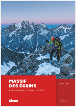
Klimgids Massif des Ecrins- Alpinisme plaisir - Ed. Glénat • 9782344015292
Klimgids - Massif des écrins, Alpinisme plaisir Productomschrijving: Ecrins-massief, plezier bergbeklimmen - Routemoeilijkheid van F tot TD Wild en authentiek massief, omdat het wordt gespaard door mechanische apparatuur en bewaard wordt door een nationaal park, zijn de Ecrins een hotspot voor bergactiviteiten in alle seizoenen en vooral voor bergbeklimmen. Met zijn hoge prestigieuze t…