
Wandelkaart 821 Columbia River Gorge - Nat Geo
130 km wandelplezier langs de mooiste zijde van deze Rivier

Korte omschrijving
TOPO Wandelkaart 821 - Columbia River Gorge - Natgeo Productomschrijving: The Columbia River Gorge is een vallei van de Columbia River in het Pacific Northwest van de United States. Met een...

Specificaties
- Uitgever: National Geographic
- ISBN-13: 9781566954730
- HOOFDCATEGORIEËN: Wandelkaart
- Regio: Oregon, USA
- Land: Verenigde Staten van Amerika (USA)
- Schaal: 1:75000
- Afmeting: 10x19
- Taal: Engels
Volledige omschrijving
TOPO Wandelkaart 821 - Columbia River Gorge - Natgeo
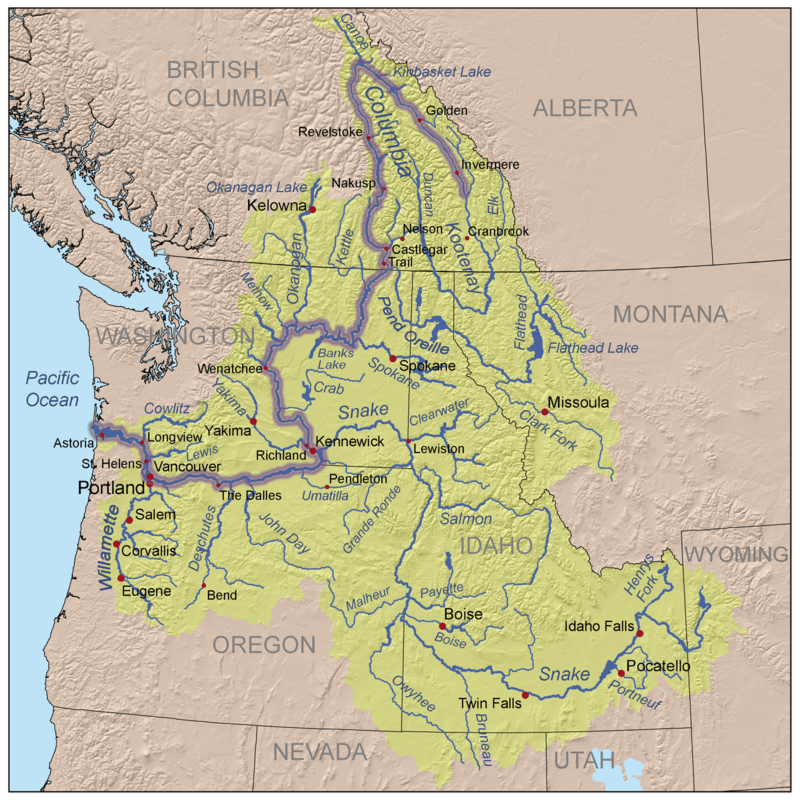
Productomschrijving: The Columbia River Gorge is een vallei van de Columbia River in het Pacific Northwest van de United States. Met een diepte van 1,200 meter, loopt de vallei voor een dikke 130 km, terwijl hij wevend door de Cascade Range loopt, die bij gevolg de grens maakt tussen de staat van Washinton in het Noorden, en de staat van Oregon in het Zuiden.
Engelse omschrijving: The magnificent Multnomah Falls is just one of many natural, cultural, and recreational attractions in the Columbia River Gorge Scenic Area. The 80-mile-long gorge contains diverse ecosystems ranging from the lush Oneonta Gorge Rain Forest to the arid Celilo Grasslands. Expertly researched and created in partnership with local land management agencies, National Geographic's Trails Illustrated map of Columbia River Gorge provides an unparalleled tool for exploring this breathtaking region. Some of the key areas of interest featured on the map include the White Salmon, Klickitat, Sandy, and Lower Deschutes rivers; Yacolt Burn State Forest; Maryhill, Columbia Hills, and Rooster Rock state parks; Mark O. Hatfield Wilderness; and portions of Mount Hood and Gifford-Pinchot national forests.
With miles of clearly marked trails including the Pacific Crest National Trail and the Oregon National Historic Trail, and such scenic roadways as the Historic Columbia River Highway and Yakima Scenic Byway, this map will prove invaluable whether you're taking in the scenery on foot or by car. A helpful list of waterfalls makes it easy to take in these natural wonders in your travels. Many recreation features are noted as well, including campgrounds, trailheads, interpretive trails, boat launches, and areas for fishing, windsurfing, and swimming. The map base includes contour lines and elevations for summits. Every Trails Illustrated map is printed on "Backcountry Tough" waterproof, tear-resistant paper. A full UTM grid is printed on the map to aid with GPS navigation.
Other features found on this map include: Bonneville Dam, Bull Run Reservoir Number One, Camas, Columbia Hills, Deschutes River, Gifford Pinchot National Forest, Gresham, Hood River, Klickitat River, Lake Celilo, Mark O. Hatfield Wilderness, Mount Defiance, Mt. Hood National Forest, Multnomah Falls, Shellrock Mountain, The Dalles, Troutdale, Washougal, White Salmon River.
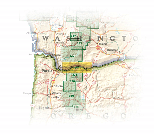
Locatie op kaart
Overzichtskaarten

NAT GEO Oregon trails map
NAT GEO Oregon trails map

Producten op de overzichtskaart
Klik op een product om naar de detailpagina te gaan.

NAT GEO Washington trail maps
NAT GEO Washington trail maps

Producten op de overzichtskaart
Klik op een product om naar de detailpagina te gaan.
Artikelen uit dezelfde regio

Wandelkaart 321 Mount Hood National Forest & Wilderness - Nat Geo • 9781566956673
Wandelkaart Mount Hood National Forest & Wilderness - Nat Geo Productomschrijving: 2 prachtige gebieden vol bos, rivieren, bergen en gletjers. Omvat: Barlow Pass, Hunchback Mountain, Mount Hood, Mount Hood Wilderness, Mt. Hood National Forest, Salmon-Huckleberry Wilderness, Zigzag Mountain. Engelse omschrijving: With its snow-covered peak, Mount Hood is an American icon and a premi…

Reisgids Oregon USA - Insight Guides ENG • 9781839053504
Reisgids Oregon USA - Insight Guides ENG Productomschrijving: Deze Insight Guide is een rijk geïllustreerde inspirerende reisgids voor Oregon en een prachtig souvenir van je reis. Perfect voor reizigers die op zoek zijn naar een diepere duik in de geschiedenis en cultuur van de bestemming en ideaal om inspiratie op te doen en je te helpen bij het plannen van je reis. Met zijn grote selecti…

Wandelkaart 244 Crater Lake National Park Oregon - Nat Geo • 9781566953023
Crater Lake National Park Oregon - Nat Geo Productomschrijving: Het overblijfsel van een vulkaan en bekend om zijn opmerkelijk blauwe water, Crater Lake is het diepste meer in de Verenigde Staten. National Geographic's Trails Illustrated kaart van Crater Lake National Park is ontworpen om te voldoen aan de behoeften van outdoor enthousiastelingen door het combineren van waardevolle informa…

Wandelkaart 820 Mount Hood & Willamette National Forest • 9781566954723
TOPO Wandelkaart 820 - Mount Hood & Willamette National Forest - Oregon USA - National Geographic Productomschrijving: Het Willamette National Forest is een National bos gelegen in het centrale deel van de Cascade Range in de U.S. satta van Oregon. Met een dikke 6,790.75 km². Een deel van 1,540 km² is echte wildernis waarin 7 grote pieken zijn vertegenwoordigd. Engelse omschrijving: W…
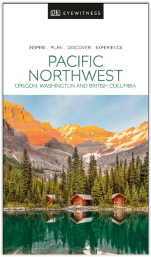
Reisgids Pacific Northwest USA - DK Eyewitness • 9780241411513
DK Eyewitness Pacific Northwest USA Omvat: Portland, Oregon, Seattle, Washington, Vancouver and British Columbia Productomschrijving: Tour de Wine Country van de North Willamette Valley, ga wandelen in het Mount Rainier National Park of verken het natuurschoon van Vancouver Island: alles wat u moet weten is overzichtelijk weergegeven in kleurgecodeerde hoofdstukken. Ontdek het beste v…