

HOOFDCATEGORIEËN
Activiteiten
Continent
Land
Regio
Schaal
Taal
Reeks/Serie:
Uitgever:
De Australische Regio's
De Franse Regio's
De Griekse Eilanden
De Italiaanse Regio's
De Scandinavische Landen
De Spaanse Regio's
Uitgever
 Wegenatlassen per land kiezen
Wegenatlassen per land kiezen,
Een wegenatlas lijkt simpel. Tot je in een boekwinkel staat met 14 varianten en nul context. Daarom werkt “per land” het best: je vertrekt van je bestemming, niet van een merk. Een goede wegenatlas geeft je overzicht én detail in één boek. Je ziet snelwegen, regionale wegen, toeristische trajecten, afstandstabellen en vaak ook een index met plaatsnamen. Dat laatste is goud waard als je niet elke afslag aan een scherm wil uitbesteden.
Gebruik een wegenatlas vooral als je routes wil plannen en onderweg wil kunnen bijsturen. Je markeert je traject, je ziet alternatieven, en je snapt meteen hoe regio’s aan elkaar hangen. Combineer je atlas met een goede wegenkaart als je dieper inzoomt op één streek. Op Bibliotrek start je logisch bij de pagina Wegenkaarten en klik je door naar je land. Voor snelle keuzes helpen landpagina’s ook: België, Frankrijk of Nederland.
Slim kiezen doe je zo: kijk naar dekking (heel land of regio), leesbaarheid, schaal, extra’s (stadsplannen, tolwegen, veerverbindingen) en actualiteit. Reis je met auto.

Wegenatlas Iceland road guide - Vegahandbokin • 9789935925497
Wegengids Iceland road guide - Vegahandbokin Productomschrijving: The Island Auto Atlas is a high-quality travel companion for car travelers with extensive road network information (road, piste, mountain and highland slopes with all road numbers), city maps, rest areas, hiking huts and tourist information. Each route is comprehensively described kilometer by kilometer; This will also …
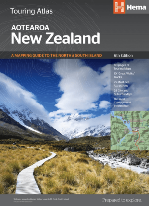
Wegenatlas Touring atlas Road Atlas Nieuw-Zeeland - Hema • 9781925625035
Wegenatlas Touring atlas Nieuw-Zeeland - Hema Productomschrijving: The New Zealand Touring Atlas is packed with information on highways and byways of the land of the long white cloud, all presented in the easy to read, easy to store format. This edition also features updated and improved NZ mapping.

Wegenatlas De Alpen A4-Formaat Ringband - Freytag & Berndt • 9783707922912
De Alpen wegenatlas - Freytag & Berndt Productomschrijving: De wegenatlas "Atlas van de Alpen 1: 150.000" is de ideale metgezel voor iedereen die in de Alpen rijdt en niet alleen snelwegen en autowegen wil gebruiken. Met het gedetailleerde kaartbeeld en de exacte schaal kunnen ook zijstraten en routes die niet op overzichtskaarten staan ??ontdekt worden. Mooie routes worden speciaal uitge…
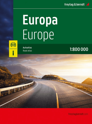
Wegenatlas Europa - Freytag & Berndt • 9783707923766
Wegenatlas Europa - F&B Productomschrijving: Deze wegenatlas is goed leesbaar. Met vele symbolen wordt informatie gegeven van o.a. campings, veerdiensten en (jeugd-)herbergen gegeven. Het wegennetwerk is goed weergeven, zowel de hoofdwegen, provinciale- en lokale wegen. Tevens worden wegnummers duidelijk vermeld. Afstanden tussen plaatsen zijn in kilometers op de kaart ingetekend, daarnaa…

Wegenatlas Zweden 2025 - Kartförlaget • 9789189427792
Wegenatlas Zweden - Kartförlaget Productomschrijving: De kaarten bevatten informatie over bezienswaardigheden, toeristische informatie, afstanden over de weg, wegnummering en meer. De atlas bevat stadsplattegronden, boot- en veerbootlijnen, themakaarten van alle landschappen, provincies en het Zweedse werelderfgoed, enz. Legende in het Zweeds.
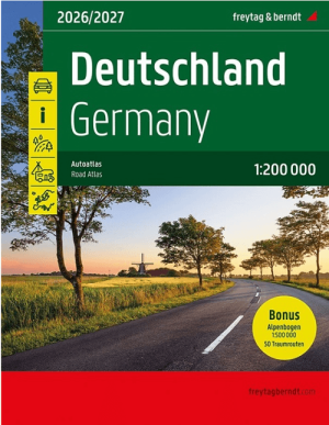
Wegenatlas Duitsland Germany Deutchland met de Alpen - F&B • 9783707923889
Wegenatlas Duitsland met de Alpen - F&B Productomschrijving: De wegenatlas "Duitsland 1: 200.000" is de ideale metgezel voor iedereen die met de auto in Duitsland reist en niet alleen snelwegen en autowegen wil gebruiken. Met het gedetailleerde kaartbeeld en de exacte schaal is het ook mogelijk om secundaire wegen en routes te ontdekken die niet op overzichtskaarten staan. Mooie routes wo…

Wegenatlas Groot Brittanië & Noord Ierland - Freytag & Berndt • 9783707924084
Wegenatlas Groot Brittanië & Noord Ierland - F&B Productomschrijving: Autoatlas Großbritannien - Nordirland 1:200.000 - 1:266.000 ist der ideale Begleiter für alle, die mit dem Auto unterwegs sind und dabei nicht nur die Hauptstraßen und Autobahnen nutzen möchten. Er ist ideal für die Planung und erweist sich auch während der Reise als unverzichtbare Orientierungshilfe. Mit dem detail…
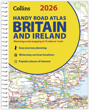
Wegenatlas Britain & Ireland road atlas A5-formaat - Collins • 9780008719227
Wegenatlas Britain & Ireland road atlas - Collins Productomschrijving: This easy-to-use, handy A5 sized road atlas with popular lie-flat spiral binding features extremely clear route planning maps of Britain and Ireland and fits neatly into your glove box or bag. The atlas has been fully updated. The maps of Britain are at 9.9 miles to 1 inch (1:625,000) and the whole of Ireland is co…
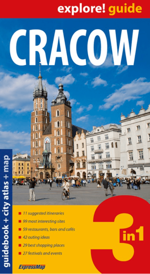
Reisgids Wegenatlas Cracow Explore guide - Expressmap • 9788375464894
Reisgids Wegenkaart Landkaart Cracow Polen - Expressmap Productomschrijving: Cracow 3 in 1 - A guidebook with a difference. Mapped out itineraries, a detailed city atlas and a folding laminated map – all prepared especially to complement the guidebook format. With this set, it is easy to plan your sightseeing tour, move about the city and find your way to selected sights. * 11 suggeste…

Wegenatlas Barcelona - Expressmap • 9788375461503
Wegenatlas Wegenkaart Barcelona - Expressmap Productomschrijving: Barcelona 3 in 1. A guidebook with a difference. Mapped out walking tours, a detailed city atlas and a folding laminated map – all prepared especially to complement the guidebook format. With this set, it is easy to plan your sightseeing tour, move about the city and find your way to selected sights. * 14 walking tours: …
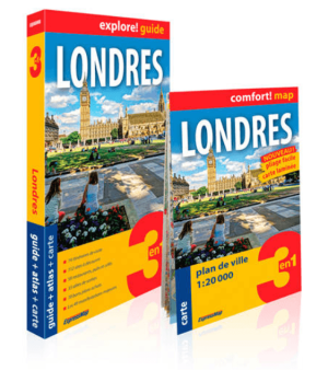
Reisgids Wegenatlas Landkaart Londres - Expressmap • 9788380461208
Reisgids Wegenatlas Londres - Expressmap Productomschrijving: 3 en 1 - Londres (Engletaire) FRANSTALIG! - La nouvelle qualité des guides. Les cartes des itinéraires, l’atlas détaillé et la carte laminée pliable ont été élaborés spécialement pour cette publication. Planifier votre séjour, vous déplacer dans la région et atteindre les sites décrits n’a jamais été aussi facile. * 14 itin…
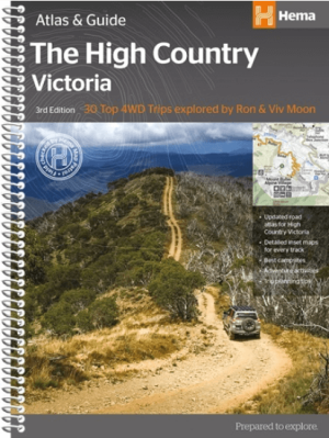
Wegenatlas Victoria High Country Atlas & Guide - Hema • 9781876413149
Wegenatlas Victoria High Country Atlas & Guide - Hema Productomschrijving: The definitive guidebook for discovering the Victorian High Country, featuring the Top 30 4WD Trips written by Ron and Viv Moon, in combination with topographic atlas mapping for the region. • 40 atlas pages at a scale of 1:150 000 • Top 30 4WD Trips • Best campsites • Adventure activities • Trip planni…

Wegenatlas Cape York Atlas & Guide - Hema Maps • 9781876413439
Wegenatlas Cape York Atlas & Guide - Hema Productomschrijving: Hema Maps’ Cape York Atlas & Guide helps you make the most of your visit to this remarkable part of Australia. With detailed coverage of The Tip, the coast from the Cairns region to Cooktown, Rinyirru (Lakefield) National Park, the Peninsula Developmental Road, Old Telegraph Track, Torres Strait and the Savannah Way, it en…

Wegenatlas The Kimberley atlas & guide - Hema Maps • 9781876413644
The Kimberley atlas & guide - Hema Productomschrijving: TOP 10 4WD Trips explored by RON And VIV MOON. This brand new edition of Hema’s best-selling outdoor guidebook for discovering the Kimberley now features 20 atlas pages in a stunning new cartographic style. The book features 10 4WD trips, explored and revised by well-known travel writers Ron and Viv Moon. This edition also no…
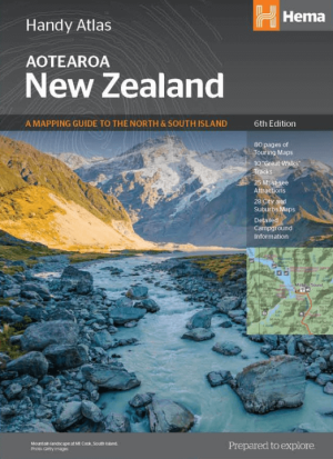
Wegenatlas Handy Atlas Nieuw-Zeeland NP - Hema Maps • 9781925625042
Handy Atlas Nieuw-Zeeland NP - Hema Productomschrijving: Compact maps for exploring the North and South Island Tour the land of the long white cloud with New Zealand's clearest and most up-to-date maps, which have - more than 1500 motorhome parks - adventure activity locations - camping grounds - additional city and national park maps for every kind of traveller. All presented…

Wegenatlas Tasmanië atlas & gids Tasmanië - Hema Maps • 9321438001973
Wegenatlas Tasmanië atlas & gids - Hema Productomschrijving: The definitive guidebook for discovering Tasmania, featuring the Top 15 4WD Trips of the State and 5 of the best walking tracks. - This first edition Tasmania Atlas & Guide contains 40 atlas pages at a large scale of 1:150 000 in a stunning cartographic style. The guide features the Top 15 4WD Trips for Tassie, which has been…

Wegenatlas K'gari (Fraser Island) & the Brisbane Islands - Hema • 9781922668820
K'gari (Fraser Island) & the Brisbane Islands - Hema Productomschrijving: K'gari (Fraser Island) Atlas & Guide (incorporating Moreton, North & South Stradbroke and Bribie Islands) - your ultimate companion for immersing yourself in the captivating wonders of K'gari, as well as the stunning neighboring islands of Moreton, North Stradbroke, South Stradbroke, and Bribie. Introducing the …

Reisgids Wegenatlas Landkaart Languedoc-Roussillon - Expressmap • 9788381909372
Reisgids Wegenkaart Languedoc-Roussillon - Expressmap Productomschrijving: 3 in 1 - Languedoc - Roussillon (FRANSTALIG) - La nouvelle qualité des guides. Les cartes des itinéraires, l’atlas détaillé et la carte laminée pliable ont été élaborés spécialement pour cette publication. Planifier votre séjour, vous déplacer dans la région et atteindre les sites décrits n’a jamais été aussi facile…
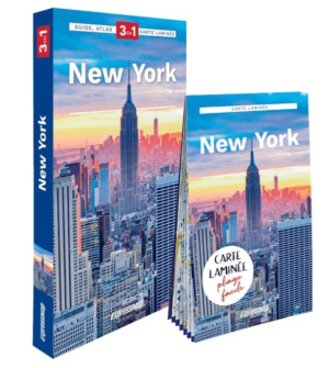
Reisgids Wegenatlas Landkaart New York - Expressmap • 9788381909389
Reisgids Wegenatlas New York - Expressmap Productomschrijving: New York 3 in 1 - A guidebook with a difference. Mapped out walking tours, a detailed city atlas and a folding laminated map – all prepared especially to complement the guidebook format. With this set, it is easy to plan your sightseeing tour, move about the city and find your way to selected sights. * 12 walking tours: 1…
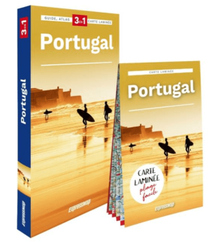
Reisgids Wegenatlas landkaart Portugal - Expressmap • 9788383551364
Reisgids Wegenatlas landkaart Portugal - Expressmap Productomschrijving: 3 en1 - Portugal (FRANSTALIG) - Le panorama inoubliable de Lisbonne vu depuis le belvédère de la Porte du Soleil, une visite dans les palais féeriques de Sintra, la détente sur les plages d’Algarve. L’ascension du Pico Ruvio, soit le toit de Madère, et une escapade au bord du lac de cratère sur les Açores. Le fado nos…
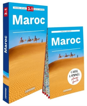
Reisgids Wegenatlas Landkaart Maroc - Expressmap • 9788383551173
Reisgids Wegenatlas Maroc - Expressmap Productomschrijving: 3 en 1 - Maroc (FRANSTALIG) - Sur quel marché peut-on acheter des herbes aromatiques en poudre, pour chasser les mauvais esprits ? Quelles eaux sont les meilleures pour pratiquer du windsurf ? Le Maroc est un pays de contrastes et de surprises. La piété islamique rencontre ici les croyances aux djinns et à la magie, et, sur la tab…
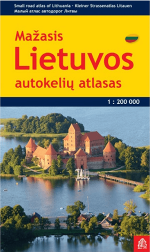
Wegenatlas compact Litouwen - Jana Seta Publ. • 9789984075556
Wegenatlas Litouwen - Jana Seta Publ. Productomschrijving: Lithuania Road Atlas from the Riga based Jana Seta, in handy glovebox paperback format with street plans of 19 towns, including an enlargement for city centre of Vilnius, The whole country is covered at 1:200,000, showing detailed classification of road network with petrol stations, and railway lines with stops. Boundaries of nati…
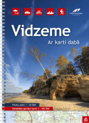
Wegenatlas Vidzeme Letland Noord - Jana Seta Publ. • 9789984076508
Wegenatlas Vidzeme Letland Noord - Jana Seta Productomschrijving: In this series have topography shown with colouring and/or graphics for orchards, forests, swamps, etc; boundaries of national parks and other protected area are clearly marked. The mapping provides a very detail presentation of the road network, from main roads to “difficult to travel” unsurfaced local roads. Locations…

Wegenatlas Noord-Amerika, Canada & Mexico - Huber • 9783943752267
Atlas Noord-Amerika, Canada & Mexico - Huber Productomschrijving: Deze gebruiksvriendelijke wegenatlas wordt gekenmerkt door een moderne cartografie. Door de spiraalrug is hij super handig in gebruik en de verschillende schalen bieden een optimale oriëntatie. De Wegenatlas Canada, USA, Mexico - De referentie voor wegen in Noord-Amerika.

Wegenatlas Kurzeme Letland west - Jana Seta Publ. • 9789984077024
Wegenatlas Kurzeme Letland west - Jana Seta Publ. Productomschrijving: In this series have topography shown with colouring and/or graphics for orchards, forests, swamps, etc; boundaries of national parks and other protected area are clearly marked. The mapping provides a very detail presentation of the road network, from main roads to “difficult to travel” unsurfaced local roads. Loca…
Stadsnavigatie zonder stress
Stadsnavigatie zonder stress,
In steden faalt digitale navigatie het hardst. Beton, tunnels, omleidingen, lage-emissiezones, parkeerlogica uit de hel. Een wegenatlas helpt je tot aan de stadsrand. Daarna wil je een duidelijke stadskaart of plattegrond. Je ziet in één oogopslag ringwegen, invalswegen, wijken, stations en belangrijke bezienswaardigheden. Je plant waar je parkeert. Je vermijdt eindeloze rondjes rijden alsof dat een hobby is.
Daarom zet je op één pagina best een brug tussen “wegen” en “stad”: je start met de wegenatlas voor de aanloop, en je schakelt over op een stadskaart voor het laatste stuk. Bibliotrek heeft hiervoor een aparte rubriek Stadskaarten & Plattegronden waar je per stad of type plan kiest. Wil je naast navigatie ook context (wijken, highlights, praktische info), dan sluit Stadsgidsen & City Guides hier mooi op aan.
Maak het concreet in je tekst: benoem citytrip-situaties (te voet, openbaar vervoer, last-mile), leg kort uit waarom papier werkt (geen batterij, direct overzicht, aantekeningen), en stuur door naar de juiste interne pagina’s. Zo verkoop je geen “nostalgie”. Je verkoopt controle. En dat klikt. Zeker bij mensen die met gezin reizen, met camper rijden, of gewoon geen zin hebben om in een onbekende stad te discussiëren met een telefoon.
Europa roadtrips in één oogopslag
Europa roadtrips in één oogopslag,
Een Europese roadtrip vraagt om schaal. Niet micro-detail, wel overzicht dat klopt. Je wil grenzen, hoofdassen, alternatieve routes, en genoeg context om te snappen waar je tijd wint of verliest. Dat is exact waar wegenatlassen en Europese wegenkaarten samen sterk staan. Je gebruikt de atlas om je grote lijn te kiezen, en je pakt een Europese wegenkaart om snel te schakelen tussen landen en regio’s. Bibliotrek heeft hiervoor een duidelijke hub Europese Wegenkaarten.
Die pagina helpt je vooral als je door meerdere landen rijdt, of als je een regio wil selecteren zonder eindeloos filteren. Vanuit daar blijf je in dezelfde logica: continent, land, regio. En als je breder wil oriënteren (wegenkaarten, stadskaarten, gidsen), dan vormt Wegen- & stadskaarten je startpunt.
Zet in deze sectie de nadruk op beslissingen die mensen echt maken: “rijd ik via kust of binnenland?”, “vermijd ik tol?”, “wil ik panoramische routes?”, “waar plan ik mijn tussenstops?”. Benoem ook waarom papier onderweg beter werkt dan je denkt: je ziet omwegen voordat je erin vastzit. Je ziet opties die een GPS niet toont omdat ze niet ‘optimaal’ zijn. Voor roadtrips is “optimaal” vaak het verkeerde doel. Je wil mooi, logisch, haalbaar.
Deze sectie verkoopt het gevoel van grip. Niet alleen het product. En ja, dat is precies waarom wegenatlassen nog altijd relevant zijn, ondanks alle apps die doen alsof ze je beste vriend zijn.