

Fietsgids Gravel Bikepacking in South East England - Cicerone
12 of the best gravel bikepacking routes in the South and East


Korte omschrijving
Fietsgidsen South & South East England van CICERONE Press. Ideaal voor tochten in England.
Gravel Bikepacking in South East England - Cicerone Productomschrijving: A guidebook to 12 of the best gravel bikepacking routes in the South and East, including the Cantii Way, exploring f...

Specificaties
- Uitgever: CICERONE Press
- ISBN-13: 9781786312372
- HOOFDCATEGORIEËN: Fietsgids
- Activiteiten: Fietsen / VTT / MTB
- Regio: South & South East England
- Land: England
- Schaal: 1:25000
- Editie: 1
- Taal: Engels
- Fietsen: Fietsen in het Buitenland
- De Engelse Graafschappen: Kent
- VTT / MTB: Mountainbike
Volledige omschrijving
Gravel Bikepacking in South East England - Cicerone
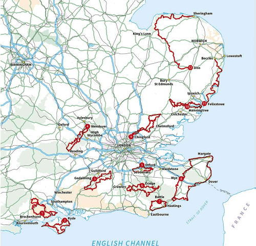
Productomschrijving: A guidebook to 12 of the best gravel bikepacking routes in the South and East, including the Cantii Way, exploring forest tracks, bridleways and quiet lanes over 1 to 5 days. Escape the urban sprawl and explore the region’s wildest off-road routes.
The cycle routes are suitable for beginner and experienced MTB and gravel-bike riders and range between 69 and 249km (40–155 miles) in length. All routes are easily accessed by public transport and close to London.
- Graded routes for all abilities
- GPX files available to download
- 1:150,000 maps and profiles included for each stage
- Handy route summary tables and accommodation listings help you plan your itinerary
- All routes easily accessible by train from London.


Artikelen uit dezelfde regio

Wandelgids Thames Valley walking guide - Cicerone • 9781852845704
Wandelgids - Thames Valley walking guide - Cicerone Productomschrijving: Deze handige gids biedt 25 avontuurlijke dagwandelingen in de Thames Valley, die betrekking hebben op de North Hampshire Downs, Berkshire en de zuidelijke Chilterns met gemakkelijke toegang tot Londen. De circulaire wandelingen variëren van 10 tot 18 mijl, waaronder een twee-daagse trot, evenals kortere route opties v…

Landkaart Wegenkaart 8 Zuidoost Engeland - OSI • 9780319263808
Wegenkaart Zuidoost Engeland - OSI Productomschrijving: Plan your journey with this series of road maps from OS. Showing all major road, rail and ferry links as well as settlements and selected features in 1: 250 000 scale, this is the ideal map for planning trips and holidays by car or cycle. OS Road 8 covers: the south-east England.

Reisgids Zuid-Engeland - Lannoo • 9789401458290
Reisgids - Zuid-Engeland - Lannoo Productomchrijving: De onmisbare gids voor echte trotters - Zuid-Engeland, de streek die je als eerste tegenkomt als je in Dover van de ferry afrijd. De streeks heeft in het miiden een AONB plaats liggen, een Area of Outstanding Natural Beauty, of een gebied van uitmund natuurschoon. De aangegeven plaatsen in deze gids zijn stuk voor stuk gevuld tot aan de…

Fietsgids 20 Rides in South East England - Cicerone • 9781852847432
Cycle the best Sportive routes in South East England Productomschrijving: Deze gids biedt 20 sportieve wielerroutes in de meest uitdagende en mooie fietsgebieden van Zuidoost-Engeland. Van Surrey en de Chiltern Hills naar het New Forest en de Berkshire Downs, het gebied heeft km's van fietsvriendelijke wegen geschikt voor sportieve training. De gesorteerde routes zijn allemaal op rustige l…

Wandelkaart OL22 New Forest- Southampton & Ringwood - OSI • 9780319475782
Wandelkaart New Forest national park - Southampton - OSI Productomschrijving: Kaart nummer OL22 in de OS Explorer kaartenserie is de perfecte kaart voor vakantiegangers en dagjesmensen om te gebruiken bij een bezoek aan het New Forest Nationaal Park in West Engeland. Het nationale park is beroemd om zijn uitstekende wandelingen en ritten en is de thuisbasis van New Forest pony's en heidela…