

Landkaart Wegenkaart 3327 Westelijke Balkan - Nat Geo
Slovenia- Croatia- Bosnia and Herzegovina- Montenegro- Albania...


Korte omschrijving
Wegen- & stadskaarten Oost Europa van National Geographic. Ideaal voor tochten in Albanië, Bosnië-Herzegovina, Kosovo, Kroatië, Macedonië, Montenegro en Servië.
Wegenkaart Westelijke Balkan - Nat Geo Productomschrijving: The Western Balkans region, an adventure playground and rising star of Europe, is loaded with Old World traditions, slow food cul...

Specificaties
- Uitgever: National Geographic
- ISBN-13: 9781566957335
- HOOFDCATEGORIEËN: Wegenkaart - Landkaart
- Activiteiten: Street/Road maps & city plans
- Auteur: National Geographic
- Regio: Oost Europa
- Land: Albanië, Bosnië-Herzegovina, Kosovo, Kroatië, Macedonië, Montenegro, Servië
- Waterafstotende kaart: Nat Geo waterproof series
- TOPO's & Stafkaarten: Topografisch wandelen
- Schaal: 1:800000
- Taal: Engels
- Reeks/Serie: NAT GEO Adventure travel maps
Volledige omschrijving
Wegenkaart Westelijke Balkan - Nat Geo
Productomschrijving: The Western Balkans region, an adventure playground and rising star of Europe, is loaded with Old World traditions, slow food culture, ancient towns, and rarely visited villages. The area stretches from the Adriatic Sea in the west, up and over mountain ranges, raging rivers, tectonic lakes, steep gorges, and thousands of miles of paths, trails, and routes. Discover eight countries—all with their special brand of Balkan magic: Slovenia, Croatia, Bosnia and Herzegovina, Montenegro, Albania, Serbia, Kosovo, and Macedonia.
National Geographic's Western Balkans Adventure Map will meet the needs of travelers with its detailed and accurate information. The map includes the locations of UNESCO World Heritage sites and exotic places to discover, including Slovenia's Triglav National Park, the walled city of Dubrovnik in Croatia, and the World Heritage Lake Ohrid in Macedonia. The map comes with a user-friendly index and clearly marked road network complete with distances and designations for roads/highways, plus secondary routes for those seeking to explore off the beaten path.
Start your adventure with a few days, weeks, or months on the 1,200-mile Via Dinarica Trail that traverses the region through the Dinaric Alps and the Sharr Mountain Range. While on the trail—or off—visit one of the many premier national parks: the waterfalls of Plitvice in Croatia; the mountainous Durmitor in Montenegro; Serbia's lush and green Tara, Theth National Park with epic views across the Albanian Alps, and the historic Sutjeska park in Bosnia and Herzegovina. And when it's time for a break, the Balkans are known for their cuisine. Farm-fresh vegetables across Macedonia, savory pastries slow-roasted over an open flame in Kosovo, and delectable seafood up and down the Adriatic coast pairs perfectly with delicious red and white wines from across the entire region.
The northern and western portions of the region—stretching from Slovenia, down Adriatic coast, and including Croatia, Montenegro, and Albania—are shown on the front side of the map. The reverse side provides details about the countries on the eastern half of the Western Balkans: Bosnia and Herzegovina, Serbia, Kosovo, and Macedonia. It overlaps the front side, roughly, along the peaks of the Dinaric Alps, which run diagonally from Slovenia to the border between Kosovo and Albania.
Every Adventure Map is printed on durable synthetic paper, making them waterproof, tear-resistant and tough — capable of withstanding the rigors of international travel.
Overzichtskaarten

NAT GEO Adventure maps EUROPE 3302 - 3328
NAT GEO Adventure maps EUROPE 3302 - 3328
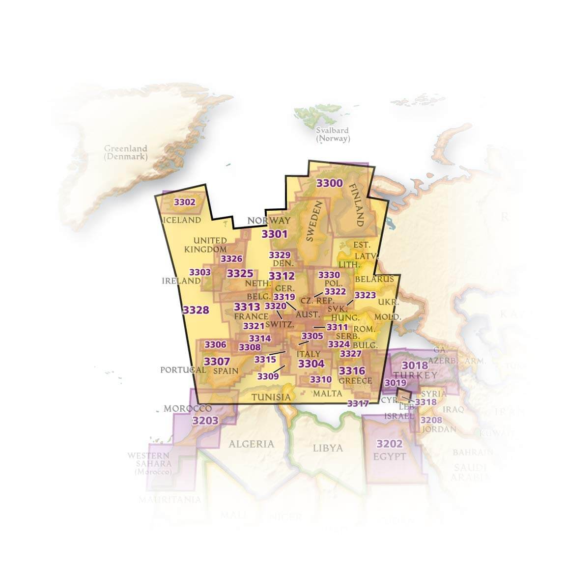
Producten op de overzichtskaart
Klik op een product om naar de detailpagina te gaan.
- Landkaart Wegenkaart 3301 Zweden Zuid & Noorwegen - Nat Geo
- Landkaart Wegenkaart 3302 Ijsland - Nat Geo
- Landkaart Wegenkaart 3303 Ierland - Nat Geo
- Landkaart Wegenkaart 3304 Italië - Nat Geo
- Landkaart Wegenkaart 3305 Toscane - Nat Geo
- Landkaart Wegenkaart 3306 Spanje Noord - Nat Geo
- Landkaart Wegenkaart 3307 Spanje & Portugal - Nat Geo
- Landkaart Wegenkaart 3308 Pyreneeën & Andorra - Nat Geo
- Landkaart Wegenkaart 3309 Sardinië - Nat Geo
- Landkaart Wegenkaart 3312 Adventure map Duitsland - Nat Geo
- Landkaart Wegenkaart 3313 Adventure map Frankrijk - Nat Geo
- Landkaart Wegenkaart 3314 Adventure map Zuid-Frankrijk - Nat Geo
- Landkaart Wegenkaart 3315 Adventure map Corsica - Nat Geo
- Landkaart Wegenkaart 3316 Adventure map Griekenland - Nat Geo
- Landkaart Wegenkaart 3317 Adventure map Kreta - Nat Geo
- Landkaart Wegenkaart 3318 Adventure map Cyprus - Nat Geo
- Landkaart Wegenkaart 3319 Adventure map Oostenrijk - Nat Geo
- Landkaart Wegenkaart 3320 Adventure map Zwitserland - Nat Geo
- Landkaart Wegenkaart 3321 De Alpen - Nat Geo
- Landkaart Wegenkaart 3322 Adventure map Tsjechië - Nat Geo
- Landkaart Wegenkaart 3323 Adventure map Slowakije - Nat Geo
- Landkaart Wegenkaart 3324 Adventure map Kroatië - Nat Geo
- Landkaart Wegenkaart 3325 Adventue map Groot-Brittannië - Nat Geo
- Landkaart Wegenkaart 3326 Adventure map Schotland - Nat Geo
- Landkaart Wegenkaart 3327 Westelijke Balkan - Nat Geo
- Landkaart Wegenkaart 3328 Europa - Nat Geo
Artikelen uit dezelfde regio

Reisgids Eastern Europe - Lonely Planet • 9781788683913
Eastern Europe - Lonely Planet Productomschrijving: Van steile bergen tot gouden zandstranden, Oost-Europa onthult een tapijt van schilderachtige en hedendaagse culturen - altijd met genoeg ruwe kantjes om je te blijven boeien. Lonely Planet brengt je naar het hart van Oost-Europa, met geweldige reiservaringen en het beste planningsadvies. Lonely Planet Eastern Europe is je paspoort vo…
Landkaart Wegenkaart Oost-Europa 125 x 87 cm - F&B • 5425013061865
Landkaart Wegenkaart Oost-Europa - F&B Productomschrijving: Gemenebest van Onafhankelijke Staten, Recto Verso kaart. Recto: GOS (Gemenebest van Onafhankelijke Staten) in schaal 1/8.000.000, elk land in een verschillende kleur + plaatsnamenregister op de kaart Verso: Oost-Europa, staatsgrenzen, met inzet: Georgia De wegenkaart van Freytag & Berndt brengen elk continent helder in b…

Landkaart Wegenkaart Oost-Europa - Jana Seta Publ. • 9789984073903
Wegenkaart Oost-Europa - Jana Seta Productomschrijving: De wegenkaart van Oost-Europa is een overzichtelijke kaart voor mensen die naar Rusland, Oekraïne en Wit-Rusland gaan. Het beslaat het deel van Europa van het schiereiland Cola in het noorden tot de Kaukasus in het zuiden en van Polen in het Westen tot de Oeral in het oosten. De kaart geeft een gedetailleerde classificatie van we…