

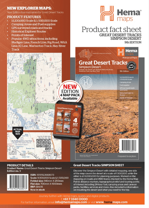
Landkaart Wegenkaart Great Desert Tracks Simpson Desert - Hema
Madigan Line- French Line- Rig Road- WAA Line- Warburton Track


Korte omschrijving
Wegenkaart Great Desert Tracks Simpson Desert - Hema Productomschrijving: Great Desert Tracks Simpson Desert (9th edition) - discover the Simpson Desert with detailed mapping, relevant poin...

Specificaties
- Uitgever: Hema Maps
- ISBN-13: 9781922668073
- HOOFDCATEGORIEËN: Wegenkaart - Landkaart
- Activiteiten: Street/Road maps & city plans
- Regio: Centraal Australië, Northern Territory, Australië, Queensland, Noord-Oost Australië, South Australia
- Land: Australië
- Schaal: 1:500000
- Editie: 9
- Taal: Engels
Volledige omschrijving
Wegenkaart Great Desert Tracks Simpson Desert - Hema
Productomschrijving: Great Desert Tracks Simpson Desert (9th edition) - discover the Simpson Desert with detailed mapping, relevant points of interest and essential touring information for the journey.
Hema's Great Desert Tracks maps are essential for anyone travelling in the Australian outback. The mapping features roads and 4WD tracks field-checked by the Hema Map Patrol, Points of Interest for remote area travellers and touring information for learning more about the region and planning your journey.
Discover the Simpson Desert with detailed mapping, relevant points of interest and essential touring information for the journey. One side of the map covers the desert at a scale of 1:500,000, while the other is at 1:1,000,000 for planning purposes. Marked on the mapping are roads and 4WD tracks checked by the Hema Map Patrol, distance markers, topographical relief and touring points of interest including 24-hour fuel, camping areas and caravan parks, facilities, services and more. Also included is information on travelling the desert, what you need for the trip and relevant contact information.
Tracks include:
- Madigan Line
- French Line
- Rig Road
- WAA Line
- K1 Line
- Warburton Track
- Hay River Track
KEY FEATURES:
- All maps field checked by the Hema Map Patrol
- Printed on durable, waterproof paper
- Shows free camping areas
- Fuel supplies
- GPS surveyed roads and tracks
- Historical explorer routes
- Points of Interest

Artikelen uit dezelfde regio
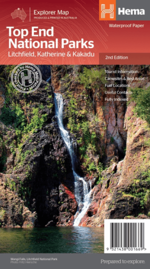
Landkaart Wegenkaart Explorer Map Top End National Parks - Hema • 9321438001669
Explorer Map Top End National Parks - Hema Productomschrijving: A regional map that features Litchfield National Park(1:160,000), Katherine Gorge and Kakadu (1:350,000) national parks. A Darwin region map is included (1:850,000) along with extensive tourist information for Darwin and the surrounding region, Arnhem Highway to Kakadu, Mary River, Stuart Highway to Katherine, Litchfield …

Landkaart Wegenkaart 43 South East Queensland - UBD Gregory's • 9780731932924
Wegenkaart South East Queensland - UBD Gregory's Productomschrijving: The latest edition of the South Eastern Queensland map has been fully revised and updated and includes regional coverage from Murgon, Gympie and Double Island Point in the north, Tenterfield and Evans Head (NSW) in the south, Columboola in the west and east along the coast from Double Island Point to Evans Head. There i…
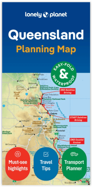
Wegenkaart Planning map Queensland Australia - Lonely Planet • 9781788688772
Planning mep Queensland Australia - Lonely Planet Productomschrijving: Lonely Planet: The world's number one travel guide publisher* Durable and waterproof, with a handy slipcase and an easy-fold format, Lonely Planet's Queensland Planning Map helps you explore with ease. Get more from your map and your trip with images and information about top attractions, itinerary suggestions, a transp…

Landkaart Wegenkaart Brisbane tot Cairns Region - Hema Maps • 9781865008714
Wegenkaart Brisbane tot Cairns Region - Hema Productomschrijving: City to City Map - via the Bruce Highway A Brisbane to the Cairns Region map at a scale of 1:1,500,000 with tourist drives map (1:3,000,000). Drive between Brisbane to Cairns with relevant touring points of interest and detailed mapping for the trip with 24-hour fuel, camping areas and caravan parks, rest areas and attra…

Landkaart Wegenkaart Explorer Map Zuidoost Queensland - Hema Maps • 9321438001638
Explorer Map Zuidoost Queensland - Hema Productomschrijving: A regional map of South East Queensland (1:500,000) that stretches from the New South Wales-Queensland border to past Bundaberg, with maps of the Brisbane Region (1:300,000), Brisbane City and the Gold Coast on the opposite side. KEY FEATURES - Inset Maps (Brisbane City and Gold Coast) - Camping & rest areas - Caravan …