
Mountainbike kaart Peak District National Park - Goldeneye
Dark Peak - White Peak - Derbyshire Dales
Korte omschrijving
Fietskaarten Derbyshire & Peak District, England van Goldeneye. Ideaal voor tochten in England.
MTB-kaart Peak District National Park - Goldeneye Productomschrijving: The Peak District National Park is a remarkable place - from the north, the upturned horseshoe of high, gritstone moor...

Specificaties
- Uitgever: Goldeneye
- ISBN-13: 9781859653012
- HOOFDCATEGORIEËN: Fietskaart
- Regio: Derbyshire & Peak District, England
- Land: England
- Nationale parken: Peak District NP, Derbyshire UK
- TOPO's & Stafkaarten: Topografisch - fietsen
- Schaal: 1:37700
- Editie: 5
- Taal: Engels
- De Engelse Graafschappen: Derbyshire, South Yorkshire
- De Nationale Parken: Peak District Nationaal Park, England
- VTT / MTB: Mountainbike
Volledige omschrijving
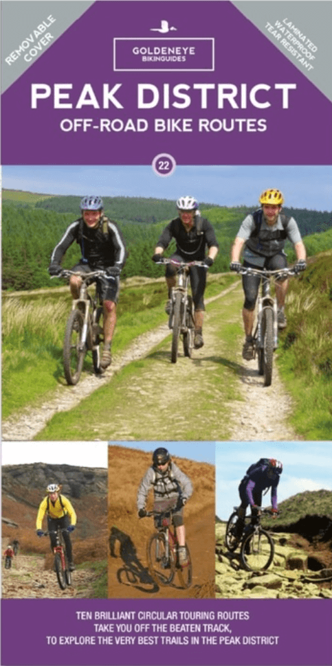
MTB-kaart Peak District National Park - Goldeneye
Productomschrijving: The Peak District National Park is a remarkable place - from the north, the upturned horseshoe of high, gritstone moors and crags of the Dark Peak extend southwards to the east and west of the contrasting limestone plateau of the softer pastoral landscape of the White Peak itself incised by the valleys of the Derbyshire Dales.
These differing landscapes offer some of the best off-road biking in Britain, from difficult, loose surfaced climbs and gnarly, rocky descents that test both nerve and technical skill, to ancient pack-horse trails, long grassy drovers' roads and converted railway tracks.
The routes are graded: easy, moderate and more strenuous. Approximate times and mileage are included.
The routes include:
1. Edale - Hayfield Circuit.
2. Hope - Jaggers Clough Circuit.
3. Castleton - Rushup Edge.
4. Ladybower South Circuit.
5. Strines & Ughill Moors Circuit.
6. Stanage Circuit.
7. Eyam - Stoney Middleton - Coombs Lane - Tideswell Lane Circuit.
8. Bakewell Circuit.
9. Parsley Hay - Middleton - Long Dale - Pikehall Circuit.
10. Winster Circuit.
Artikelen uit dezelfde regio

Wandelkaart XT25 Peak District Central - Harvey Maps • 9781851376537
Wandelkaart Peak District Central - Harvey Maps Productomschrijving: Gedetailleerde kaart voor bergwandelaars in het hart van het Peak District National Park. Het Peak District National Park is een zeer heuvelrijk landschap ten zuiden van het Penninisch Gebergte in het noorden van Engeland. Het gebied is beschermd. Omvat: Edale, Kinder Scout, de Gritstone Edges en Ladybower Reservoir. …

Wandelgids Peak District - 50 walks guide - AA Publishing • 9780749583262
Peak District - 50 walks guide - AA Publishing Productomschrijving: Wandelen is een van de favoriete vrijetijdsbestedingen van Groot-Brittannië. Deze AA gids - 50 wandelingen in het Peak District, bevat een verscheidenheid aan uitgestippelde wandelingen van twee tot tien mijl, geschikt voor alle niveaus. Het boek bevat alle praktische details die je nodig hebt, vergezeld van fascinerende a…

Wandelgids 063 Pathfinder guides Peak District England - OS • 9780319090275
Wandelgids Peak District England - OS Productomschrijving: The Pathfinder Guide for the Lake District is the ideal companion to gaining an appreciation of England's most mountainous region with its balanced range of walks across the whole of the National Park. There are a total of 28 outstanding circular walks in the Lake District National Park from 3 to 10 miles with easy-to-follow route…

Wandelkaart White Peak - Peak District NP - Harvey maps • 9781851375134
Wandelkaart White Peak" Alle witte piekheuvels en dales op een enkele kaart. De achterzijde van de kaart omvat: Oost-Matlock en Noord naar Edale, geologische kaart. Productomschrijving: Nieuwe generatie HARVEY Superwalker, XT25 waterproof, werden ontworpen om de meest praktische tools te zijn voor GPS-navigatie. Het formaat geeft meer toewijzingen op het blad zonder de kaart zwaarder e…

Wandelgids The Pennine Way - Trailblazer • 9781912716333
The Pennine Way 420 km - Trailblazer Productomschrijving: De Pennine Way, het bekendste nationale pad van Groot-Brittannië, slingert zich 420 km over woeste heidevelden en door stille dalen langs de ruggengraat van Noord-Engeland. Het begint in Edale in het Peak District en eindigt net over de grens in Schotland bij Kirk Yetholm. Dit prachtige wandelpad doorkruist 3 nationale parken - het …