

Plano Wandkaart Nationale Parken USA 107 x 76 cm - Nat Geo
Geplastificeerd


Korte omschrijving
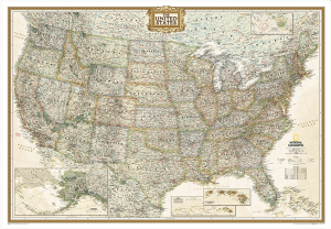
Wandkaart Nationale Parken USA 107 x 76 cm - Nat Geo Productomschrijving: National Geographic's wall map of National Parks of the United States highlights the nearly 400 magnificent parks ac...

Specificaties
- Uitgever: National Geographic
- ISBN-13: 9781597754248
- HOOFDCATEGORIEËN: WandkaartenPlanokaart/opgerold
- Activiteiten: Wandkaarten
- Regio: Verenigde staten van Amerika
- Land: Verenigde Staten van Amerika (USA)
- Waterafstotende kaart: National Geographic, Geplastificeerd
- Nationale parken: Everglades NP, Florida USA, Grand Canyon NP, Arizona, Great smoky mountains NP, Tennessee USA, Yellowstone NP, Wyoming USA, Yosemeti NP, California USA, Zion & Bryce Canyon national park, Utah, USA
- Schaal: 1:5200000
- Taal: Engels
- Reeks/Serie: Planokaart/opgerold
- Wandkaarten & Planokaarten: Wandkaarten & Planokaarten
Volledige omschrijving
Wandkaart Nationale Parken USA 107 x 76 cm - Nat Geo
Productomschrijving: National Geographic's wall map of National Parks of the United States highlights the nearly 400 magnificent parks across America. The country is represented in subtle earth-tones with shaded mountain relief and intricately drawn river systems. Photos capture some of the diverse landscapes preserved and protected by the national park system.
Separate inset maps provide detail and descriptions of seven of the parks: Yellowstone, Yosemite, Acadia, Grand Canyon, Great Smoky Mountains, Everglades, and Zion. Parks located in U.S. territories are included on an inset world map.
Includes insets of the Yellowstone, Yosemite, Acadia, Grand Canyon, Great Smoky Mountains, Everglades, and Zion National Parks, an inset world map showing outlying U.S. National Parks, a list of parks near metropolitan areas.
Afmeting: 107 x 76 cm
Artikelen uit dezelfde regio
Politiek & Antieke Wandkaart GROOT USA 178 x 122 cm - Nat Geo • 9780792233794
Plano Politiek & Antieke Wandkaart USA - Nat Geo Productomschrijving: National Geographic's Executive reference map of the United States features all 50 States with insets for Alaska and Hawaii in antique-executive cartographic style. Each state is colored to clearly define borders and shaded relief accentuates geographical features. All major cities, transportation routes, state boundarie…

Reisgids USA - Lonely Planet • 9781837587230
Reisgids USA - Lonely Planet Productomschrijving: Gaze into the mile-deep chasm of the Grand Canyon, hang 10 on an iconic Hawaiian wave, or let sultry southern music and food stir your soul; all with your trusted travel companion. Get to the heart of the USA and begin your journey now! Inside Lonely Planet USA Travel Guide: - Colour maps and images throughout Highlights and itinera…

Landkaart Planing map USA - Lonely Planet • 9781787017887
Planning map USA - Lonely Planet Productomschrijving: Durable and waterproof, with a handy slipcase and an easy-fold format, Lonely Planet USA Planning Map is your conveniently-sized passport to traveling with ease. Get more from your map and your trip with images and information about top country attractions, itinerary suggestions, a transport guide, planning information, themed lists and…

Reisgids USA - Rough Guides • 9781839059872
Reisgids Verenigde Staten - Rough Guides Productomschrijving: De Rough Guide to the USA is de ultieme gids voor alle vijftig staten. Of je nu een enorme cross-country road-trip plant, een actievolle tocht door de Rockies, of gewoon een luie tijd luieren aan de beste stranden van de westkust, deze volledig bijgewerkte gids zal je helpen bij elke stap van de weg. De Rough Guide to the USA zi…

Plano Politieke Wandkaart Amerika Noord + Zuid 60 x 94 - Nat Geo • 9780792250210
Wandkaart Amerika Noord + Zuid - Nat Geo Prodoductomschrijving: National Geographic's Classic style political wall map of The Americas features a bright color palette with blue oceans and the continents' terrain detailed in stunning shaded relief that has been a hallmark of National Geographic wall maps for over 75 years. A physical map of The Americas is provided as an inset. This map inc…
