
Reisgids Scottish Highlands & Islands - Rough guides
A fully updated The Rough Guide to Scottish Highlands


Korte omschrijving
Reisgidsen Highlands, Schotland, Inner hybrids (Binnen-Hebriden), Schotland, Schetland Islands, Schotland, Outer Hybrids, (Buiten Hybriden) Schotland en Orkney Islands, Schotland van Rough Guides. Ideaal voor tochten in Schotland.
Scottish Highlands & Islands - Rough guides Product description: This fully updated The Rough Guide to Scottish Highlands and Islands is the ultimate guidebook to the captivating remote reac...

Specificaties
- Uitgever: Rough Guides
- ISBN-13: 9780241272312
- HOOFDCATEGORIEËN: Reisgids
- Activiteiten: Toerisme
- Regio: Highlands, Schotland, Inner hybrids (Binnen-Hebriden), Schotland, Orkney Islands, Schotland, Outer Hybrids, (Buiten Hybriden) Schotland, Schetland Islands, Schotland
- Land: Schotland
- Editie: 8
- Taal: Engels
- Reeks/Serie: Rough Guides Mini
- De beroemdste Eilandengroepen: Inner Hybrids (Schotland), Isle of Skye (Schotland), Orkney Islands (Schotland), Outer Hybrids (Schotland), Schetland Islands (Schotland)
- Iconische Bergketens van Europa: De Schotse Highlands
Volledige omschrijving
Scottish Highlands & Islands - Rough guides
Product description: This fully updated The Rough Guide to Scottish Highlands and Islands is the ultimate guidebook to the captivating remote reaches of Scotland. From the divine seafood offerings at Loch Fyne to the whisky distilleries on Islay, this is a place for indulging. It’s also a hotspot for outdoor activities, whether you decide to bag a Munro or two, hop onto a mountain bike or stroll along deserted (if blustery) golden beaches.
The Rough Guide to Scottish Highlands and Islands contains more information than ever on where to go and what to see in this part of Scotland, with practical information on everything from events listings to transport logistics. There’s also coverage of the brand new North Coast 500 route, which loops around the northernmost reaches of the country.
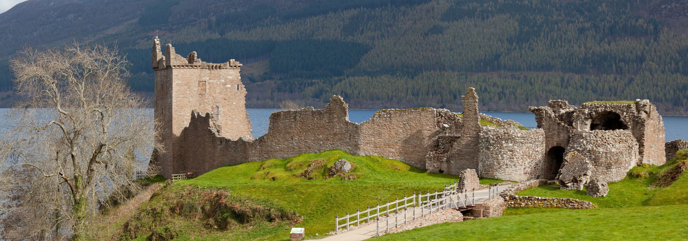
From Skye’s breathtaking Cuillin ridge to abandoned castles, via riproaring unplanned ceilidhs, this stark and weather beaten part of the planet will not disappoint.
Locatie op kaart
Artikelen uit dezelfde regio

Wandelkaart 391 Ardgour & Strontian- Highlands - OSI • 9780319246344
Wandelkaart Ardgour & Strontian - Highlands Schotland Productbeschrijving: Glenfinnan, Loch Eil & Loch Shiel 391 Ardgour / Strontian, Highlands Schotland - Kaart nummer 391 in de OS Explorer kaart reeks is ideaal voor ontdekken van het gebied in de buurt van Ben Nevis. Loch Linnhe, en ligt ten westen van Ben Nevis en Glen Coe met prachtige landschappen en uitdagende wandelingen, die er…

Wandelgids Day Walks on the Isle of Skye - Vertebrate Publ. • 9781839811517
Day Walks on the Isle of Skye - Vertebrate Productomschrijving: 20 routes on the Isle of Skye Day Walks on the Isle of Skye features 20 routes between 3.4 and 14.5 miles (5.5km and 23.3km) in length, spread across the Isle of Skye with one walk on the neighbouring Isle of Raasay. Researched and written by experienced and knowledgeable authors Helen and Paul Webster, founders of the Wal…
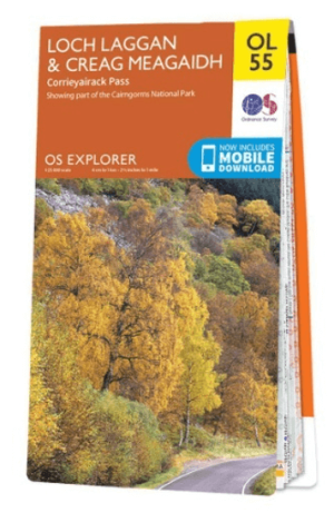
Wandelkaart OL55 Loch Laggan, Creag Meagaidh & Corrieyairack - OS • 9780319242940
Wandelkaart Loch Laggan, Creag Meagaidh & Corrieyairack - OS Productomschrijving: Loch Laggan, Creag Meagaidh & Corrieyairack, parts of the Cairngorms National Park, Omvat: Loch Laggan, Creag Meagaidh & Corrieyairack, Corrieyairack Pass, parts of the Cairngorms National Park & The Great Glenn Way. Ontdek de OL-serie van Ordnance Survey: De OL-serie (Outdoor Leisure) van Ordnance …

Wandelkaart 428 Kyle of Lochalsh Schotland - OSI • 9780319472804
Wandelkaart Kyle of Lochalsh - Highland's Schotland Productbeschrijving: OS Explorer kaart 428 omvat de westelijke kant van de Wester Ross nationale Scenic Area. U kunt er ook de ruige kustlijn en kleine dorpjes gaan verkennen. De OS Explorer kaart voor Kyle van Lochalsh, Plockton & Applecross is beschikbaar in zowel de standaard papieren versie als de weerbestendige 'Actief' versie. P…

Landkaart Wegenkaart 2 Schotland West & Western Isles - OSI • 9780319263747
Wegenkaart Schotland West & Western Isles - OSI Productomschrijving: Plan your journey with this series of road maps from OS. Showing all major road, rail and ferry links as well as settlements and selected features in 1: 250 000 scale, this is the ideal map for planning trips and holidays by car or cycle. OS Road 2 covers: Scotland's west coast, including the Western Isles (Hebrides)…