

Wandelgids Day Walks in Fort William & Glen Coe - Vertebrate publ
20 routes in the Scottish Highlands

Korte omschrijving
Wandelgidsen Northern Schotland, Highlands & Islands en Highlands, Schotland van Vertebrate Publishing. Ideaal voor tochten in Schotland.
Day Walks in Fort William & Glen Coe Scotland Productomschrijving: 20 routes in the Scottish Highlands Day Walks in Fort William & Glen Coe features 20 routes between 4.4 and 14.4 miles...

Specificaties
- Uitgever: Vertebrate Publishing
- ISBN-13: 9781912560646
- HOOFDCATEGORIEËN: Wandelgids
- Activiteiten: Wandelen, Hiking & Trekking
- Auteur: Helen Webster, Paul Webster
- Regio: Highlands, Schotland, Northern Schotland, Highlands & Islands
- Land: Schotland
- Lange afstand wandelroutes: West Highland Way, Schotland (152 km)
- Taal: Engels
- Reeks/Serie: Day walks in, vertebrate Publishing
- Iconische Bergketens van Europa: De Schotse Highlands
- Iconische Wandelroutes: West Highland Way, Schotland
- De Schotse Munro's: De Schotse Munro's
Volledige omschrijving
Day Walks in Fort William & Glen Coe Scotland
Productomschrijving: 20 routes in the Scottish Highlands
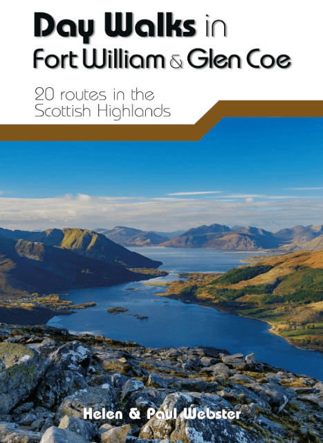
Day Walks in Fort William & Glen Coe features 20 routes between 4.4 and 14.4 miles (7km and 23.2km) in length, spread across the Scottish Highlands. Researched and written by experienced and knowledgeable authors Helen and Paul Webster, founders of the Walkhighlands website, the walks range from gentle rambles to more challenging day walks, all through grand and impressive landscapes. Split into four sections – Glen Coe & Glen Etive, Kinlochleven & the Mamores, Fort William & the Great Glen, and The Road to the Isles – this guidebook explores the best that the Highlands has to offer. Together with stunning photography, each route features Ordnance Survey 1:25,000 maps, easy-to-follow directions, details of distance and navigation information, and refreshment stops and local information.

Artikelen uit dezelfde regio

Wandelkaart 400 Loch Lochy & Glen Roy- Highlands - OSI • 9780319246405
Wandelkaart Loch Lochy & Glen Roy - Highlands Schotland Omvat ook: Spean Bridge, Invergarry & Fort Augustus. Productbeschrijving: Kaart nummer 400 in de OS Explorer kaart reeks is ideaal voor het ontdekken van het gebied rondom Loch Lochy. De derde-diepste Loch in Schotland, Loch Lochy kan worden ontdekt door de Great Glen way, langs de volledige lengte van de loch, van Spean Bridge in…

Wandelkaart 407 Isle of Skye & Dunvegan- Highland's - OSI • 9780319246429
Wandelkaart Isle of Skye & Dunvegan - Highland's Schotland Omvat ook: Waternish & Macleod’s Tables. Productbeschrijving: Kaart nummer 407 in de OS Explorer kaarten reeks is de perfecte kaart om te gebruiken bij het verkennen van "The Isle of Skye", Dunvegan, Waternish en de Macleod's tables. Het gebied is rijk aan geschiedenis en de perfecte plek om te genieten van kust wandelingen. Ho…

Wandelgids Walking the Munros Vol 1 - Cicerone Press • 9781786311054
Walking the Munros Vol 1 - Cicerone Productomschrijving: Wandelgids over de Munros in de zuidelijke, centrale en westelijke Highland's. De gids beschrijft 69 uitdagende routes over 139 van de meest iconische 3000f+ bergen in gebieden zoals Glencoe, Bridge of Orchy en Mull. Inclusief routes op Ben More, Ben Alder, Ben Lomond en Ben Nevis, de hoogste berg van de Britse eilanden. Deel 1 van t…

Wandelkaart 27 Nairn & Forres- Highland's Schotland - OSI • 9780319261255
Wandelkaart Nairn & Forres - Highland's Schotland Productbeschrijving: OS Landranger kaart 27 toont de Moray Firth, net ten oosten van Inverness. De kust stad van Nairn is een populaire vakantiebestemming, of neem de Moray Coastal Trail langs Forres aan de Findhorn. De OS Landranger kaarten reeks heeft betrekking op Groot-Brittannië met 204 gedetailleerde kaarten, perfect voor dagtocht…

Wandelkaart 377 Loch Etive & Glen Orchy- Schotland - OSI • 9780319472446
Wandelkaart Loch Etive & Glen Orchy - Highlands Schotland Omvat ook: Dalmally, Tyndrum, Bridge of Orchy & Taynuilt. Productbeschrijving: Dubbel zijdige OS Explorer kaart 377 toont de omgeving van Loch Etive tot aan Loch Lomond en de Trossarchs National Park. Naast een substantieel deel van de West Highland way zijn er 21 Munro's om op zak te steken, samen een deel van de Ben Nevis en d…