

Wandelgids The Big Rounds - Cicerone
De Lake district- Snowdonia & de Cairngorms in Schotland


Korte omschrijving
Wandelgidsen Cumbria & Lake District, England van CICERONE Press. Ideaal voor tochten in England.
Wandelgids - The Big Rounds - Cicerone Productomschrijving: Deze inspirerende gids kijkt naar elk van de 19 nationale routes in het Verenigd Koninkrijk, met informatie die vergelijkings- en ...

Specificaties
- Uitgever: CICERONE Press
- ISBN-13: 9781852847722
- HOOFDCATEGORIEËN: Wandelgids
- Activiteiten: Wandelen, Hiking & Trekking
- Auteur: David Lintern
- Regio: Cumbria & Lake District, England
- Land: England
- Nationale parken: Cairngorms NP, Schotland, Lake District NP, Cumbria England, Snowdonia NP, Wales UK
- Editie: 1
- Taal: Engels
Volledige omschrijving
Wandelgids - The Big Rounds - Cicerone
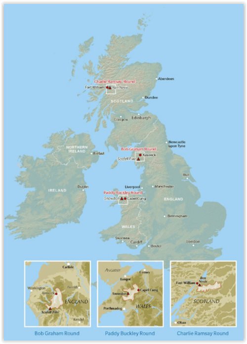
Productomschrijving: Deze inspirerende gids kijkt naar elk van de 19 nationale routes in het Verenigd Koninkrijk, met informatie die vergelijkings- en contrastgemak mogelijk maakt, waardoor u wordt geïnspireerd om meer te weten te komen en een uitdaging op lange afstand aan te gaan. Sommige paden zijn kort en gemakkelijk, anderen veel langer, en veel hebben sterke thema's - ze kunnen een kustlijn volgen of heuvels doorkruisen. Deze gids brengt u in- en rond 3 majestieuze nationale parken in Engeland, Wales & Schotland: De Lake district, Snowdonia in Wales en de Cairngorms in Schotland.
Product description: This inspirational guidebook looks at each of the UK's 19 National Trails, with information that allows ease of comparison and contrast, inspiring you to find out more and to take up a long-distance challenge. Some Trails are short and easy, others much longer, many have strong themes - they may follow a coastline, or traverse ranges of hills.
Seasons:
All trails can be tackled throughout the year, though many of the northern and Scottish routes can be challenging in winter conditions. Avoid the Hadrian's Wall Path in winter, as the ground is soft and underlying archaeology easily damaged.
Difficulty:
The routes vary in both length and technical difficulty, the longest being the South West Coast Path and the most difficult possibly the Pennine Way.
Must See:
Broad views and unspoilt landscapes in some of Britain's best walking areas - from thunderous breaking waves against the cliffs on the South West Coast Path to Buachaille Etive Mor at the gateway to Glen Coe.

Locatie op kaart
Artikelen uit dezelfde regio

Wandelgids Lake District short walks - Cicerone • 9781786312020
Lake District short walks - Cicerone Productomschrijving: Vivienne Crow heeft 15 van de beste korte wandelingen rond Keswick, Borrowdale en Buttermere uitgekozen. Elke wandeling is voorzien van goed leesbare Ordnance Survey-kaarten, een duidelijke routebeschrijving en veel afbeeldingen, plus informatie over plaatselijke mooie plekjes en smakelijke stops om iets te drinken. Geen moeilijk te…
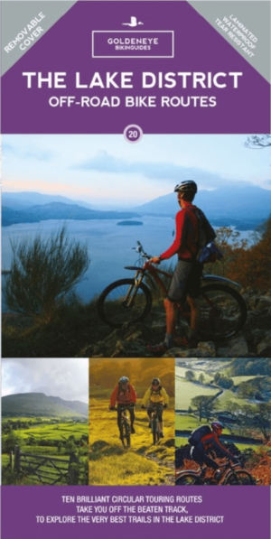
Mountainbike kaart Lake District NP - Goldeneye • 9781859653005
MTB kaart Lake District NP - Goldeneye Productomschrijving: The routes are graded with approximate time & mileage. Unsurprisingly, the mountainous landscape of the Lake District has some of the toughest mountain biking in the UK and, on major routes crossing the steep sided ridges between major valleys, long pushes or carries are inescapable - even for the fittest. This is only one asp…
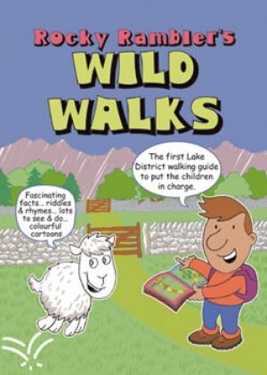
Wandelgids Rocky Rambler's wild walks - Cicerone • 9781852843472
Wandelgids - Rocky Rambler's wild walks - Cicerone Productomschrijving: Een gids over familiewandelen in het Lake District. Rocky Rambler's Wild Walks stimuleert kinderen om uit te kiezen, en de wandelingen te leiden. Gericht op kinderen van 6 tot 14 jaar, de gids bevat duidelijke instructies en heldere illustraties, die iedere wandeling gemakkelijk en leuk maakt om te volgen. 10 wandeling…

Wandelgids The Pennine Way - Trailblazer • 9781912716333
The Pennine Way 420 km - Trailblazer Productomschrijving: De Pennine Way, het bekendste nationale pad van Groot-Brittannië, slingert zich 420 km over woeste heidevelden en door stille dalen langs de ruggengraat van Noord-Engeland. Het begint in Edale in het Peak District en eindigt net over de grens in Schotland bij Kirk Yetholm. Dit prachtige wandelpad doorkruist 3 nationale parken - het …

Wandelkaart Lake District West - XT40 ultra - Harvey Maps • 9781851377190
Wandelkaart Lake District West - Harvey Maps Productomschrijving: Omvat een groot gebied maar is praktisch en compact, zakformaat - Gedetailleerde kaart voor lopers en wandelaars van de westelijke heuvels van het Lake District National Park. - Scafell en de Langdale Pikes, en fells ten westen van de Kendal-Keswick-weg. - Hard Knott en Wrynose passen. Ennerdale, Wast Water en Conist…