

Wandelgids The Kennet and Avon Canal walk - Cicerone
The Full Canal Walk and 20 Day Walks


Korte omschrijving
Wandelgidsen South & South East England, Wiltshire, West England en Berkshire South West England van CICERONE Press. Ideaal voor tochten in England.
The Kennet and Avon Canal walk - Cicerone Productomschrijving: Wandelgids langs het Kennet & Avon kanaal. De 151 Km lange route van Reading naar Bristol is verdeeld in 7 etappes van redelijk...

Specificaties
- Uitgever: CICERONE Press
- ISBN-13: 9781786312303
- HOOFDCATEGORIEËN: Wandelgids
- Activiteiten: Wandelen, Hiking & Trekking
- Auteur: Steve Davison
- Regio: Berkshire South West England, South & South East England, Wiltshire, West England
- Land: England
- Editie: 2
- Taal: Engels
Volledige omschrijving
The Kennet and Avon Canal walk - Cicerone
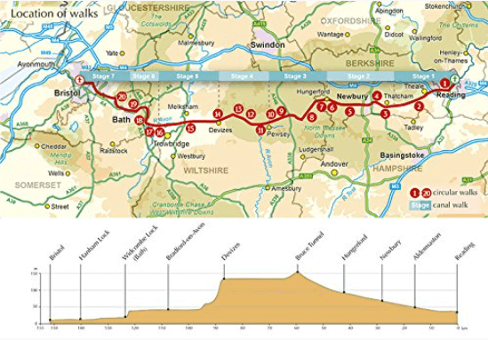
Productomschrijving: Wandelgids langs het Kennet & Avon kanaal. De 151 Km lange route van Reading naar Bristol is verdeeld in 7 etappes van redelijk gemakkelijke wandelingen en omvat het UNESCO werelderfgoed Bath en de drijvende haven van Bristol. Er zijn ook 20 rondwandelingen opgenomen, variërend van 4¼ tot 9 mijl, waarbij de beste delen van het kanaal worden aangedaan.
Engelse omschrijving: Guidebook to walking along the Kennet & Avon Canal. The 94 mile route from Reading to Bristol is split into 7 stages of fairly easy walking and includes the UNESCO World Heritage Site of Bath and Bristol's Floating Harbour. 20 circular walks are also included, ranging from 4¼ to 9 miles, taking in the best sections of the canal.
Seasons:
The canal and walks can be undertaken at any time: summers tend to be fairly dry and mild, spring and autumn offer some of the best walking conditions. In winter some paths can be quite muddy and some routes may be impassable if rivers become flooded - however, walking alongside the canal on a clear, frosty winter's day can be a magical experience.
Centres:
Reading, Newbury, Hungerford, Great Bedwyn, Pewsey, Devizes, Bradford-on-Avon, Bath, Keynsham and Bristol.
Difficulty:
Fairly easy walking on mostly good paths and tracks through fairly low-level terrain (below 286m above sea level). The stages on the canal walk range in length from 15.5 to 29.7 km (9¾ to 18½ miles); however, these can be easily split into shorter stages if required. The circular walks range from 6.8 to 14.5 km (4¼ to 9 miles) and include several, sometimes steep, ascents and descents, however, they should be suitable for most walkers.
Must See:
Numerous fascinating features along the canal, such as Crofton Pumping Station, the impressive Caen Hill flight of locks at Devizes, aqueducts at Avoncliff and Dundas, picturesque towns and villages, with pubs, ancient churches; Georgian splendour at Bath, a UNESCO World Heritage Site, vibrant Bristol and its Floating Harbour, the canal travels through an interesting, gentle landscape, ranging from the rolling chalk hills of the North Wessex Downs AONB in the east to the limestone country in the west, touching on the southern edge of the Cotswolds AONB.
Artikelen uit dezelfde regio

Wandelgids 025 Pathfinder guides Thames Valley & Chilterns - OS • 9780319090053
Wandelgids The Thames Valley & The Chilterns AONB Productomschrijving: The Chilterns AONB form part of the long line of chalk hills stretching intermittently across southern and eastern England. It is an area characterised by beech woods and dry valleys, and these natural features are explored in the 28 routes available in this walks guidebook. The Thames Valley is steeped in history,…

Wandelgids - Guide to the Cotswolds AONB - AA • 9780749579418
Wandelgids - Guide to the Cotswolds AONB - AA Productomschrijving: The Cotswolds zijn een regio van uitmuntend natuurlijk schoon, of in andere woorden, "Area of Outstanding Natural Beauty". Zo noemen de britten hun meest geliefde regio's. WIj spreken oven nationale parken or regionale parken, terwijl de britten er eveneens over beschikken, maar de AONB's gaan voor op de rest. Talloze route…

Wandelkaart 143 Warminster & Trowbridge - Wiltshire - OSI • 9780319243367
Wandelkaart Warminster & Trowbridge - Wiltshire England Omvat ook: Westbury & Mere. Productbeschrijving: Kaart nummer 143 in de OS Explorer kaarten reeks heeft betrekking op het westen van Wiltshire, als ook Cranbone Chase & de West Wiltshire Downs. Hoogtepunten van het gebied zijn onder andere: Mid Wilts Way, Wessex Ridgeway, Monarch's Way en Imber Range Perimeter Path. De OS Explorer…

Wandelkaart 157 Marlborough & Savernake Forest - OSI • 9780319243503
Wandelkaart Marlborough - North Wessex Downs AONB Omvat ook: Avebury & Devizes Productomschrijving: Kaart nummer 157 in de OS Explorer kaarten reeks omvat Marlborough, Avebury en Devizes in Wiltshire. Hoogtepunten van het gebied zijn onder andere: een deel van het grote bos voor van de Western North Wessex Downs AONB, Savernake Forest, Avebury Rings, Wessex Ridgeway, The Ridgeway, de W…

Wandelgids Sarsen Way Guidebook - Cicerone • 9781786311269
Wandelgids Sarsen Way Guidebook - Cicerone Productomschrijving: Gids over de Sarsen Way (79 km) van Coate Water Park naar Salisbury en de Cranborne Droves Way (28 km) die Salisbury verbindt met de Wessex Ridgeway bij Win Green. Deze langeafstandspaden maken deel uit van de Great Chalk Way. Beide kunnen in een week gelopen worden en zijn geschikt voor alle niveaus. De routes worden gep…