

Wandelgids Wicklow Way - Rucksack Readers
From Marlay Park & Clonegal through the Wicklow mountains 132 Km


Korte omschrijving
Wandelgidsen County Wicklow, Ireland van RUCKSACK READERS. Ideaal voor tochten in Ierland.
Wandelgids Wicklow Way - Rucksack Readers Productomschrijving: The Wicklow Way, is Ireland's first and most popular Waymarked Way, running between Marlay Park (Dublin) and Clonegal, 82 mile...

Specificaties
- Uitgever: RUCKSACK READERS
- ISBN-13: 9781913817282
- HOOFDCATEGORIEËN: Wandelgids
- Activiteiten: Wandelen, Hiking & Trekking
- Auteur: Jacquetta Megarry, Sandra Bardwell
- Regio: County Wicklow, Ireland
- Land: Ierland
- Toepasselijke bergketen: Wicklow Momuntains, Ireland
- Lange afstand wandelroutes: Wicklow Way, Ireland (132 km)
- Nationale parken: Wicklow National Park, Ireland
- Schaal: 1:100000
- Editie: 4
- Taal: Engels
- De Nationale Parken: Wicklow Mountains National Park, Ireland
Volledige omschrijving
Wandelgids Wicklow Way - Rucksack Readers
Productomschrijving: The Wicklow Way, is Ireland's first and most popular Waymarked Way, running between Marlay Park (Dublin) and Clonegal, 82 miles (132 km) to the south. It offers varied and scenic walking on the flanks of the rugged Wicklow mountains with loughs and waterfalls, passing historic buildings and hospitable villages. Much of the route lies over 1600 feet (500 metres) giving glorious views. Lower sections run through forests and farmland, over a mixture of tracks, roads and pathways rich in wildlife.
This edition is based on a research trip made in Spring 2008, revised in 2011 and again in 2015 and 2017. It has many route updates, extra photographs and it explains new options for accommodation. We expect to have stock in August 2017 and meantime you can pre-order at the old price of £10.99 if you wish.
It contains all you need to plan and enjoy your holiday on the Wicklow Way:
• Detailed route description, updated in 2017, with distance, terrain and food and drink
• The secrets of how to book accommodation to avoid walking extra distances
• Concise background on history, geology and wildlife
• Extended 6-page feature on the monastic city of Glendalough
• Planning information for travel by car, train, bus or plane
• In full colour, with 80 photographs.
• Drop-down map of the Wicklow Way in five panels (1:100,000)
• On waterproof paper throughout.
Artikelen uit dezelfde regio

Wandelkaart 56 County Wicklow, Kildare & Dublin - OSI • 9781912140343
Wandelkaart County Wicklow, Kildare & Dublin - OSI Productomschrijving: Ontdek Ierland met de Discovery Series Wandelkaarten van Ordnance Survey Ireland. Omvat: de Counties Wicklow, Kildare & Dublin De Discovery Series wandelkaarten van Ordnance Survey Ireland (OSi) zijn dé keuze voor wandelaars, fietsers en avonturiers die Ierland echt willen verkennen. Deze hoogwaardige topograf…
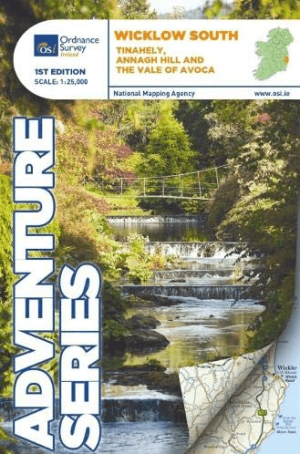
Wandelkaart Adventure Series Wicklow South - OSI • 9781908852380
Wandelkaart Wicklow South - OSI Productomschrijving: This map is situated in County Wicklow, County Carlow and County Wexford. Roads shown on this map include R752, R753, R747 and R748. A short portion of the M11 at Arklow is shown. The railway which runs through the Vale of Avoca to Arklow town is shown. Among the towns and villages shown on this map are Avoca, Aughrim, Arklow western sec…

Wandelkaart 61 County Carlow, Kildare, Kilkenny, Laois & Wicklow - OSI • 9781912140114
Wandelkaart County Carlow, Kildare, Kilkenny, Laois & Wicklow Productomschrijving: Ontdek Ierland met de Discovery Series Wandelkaarten van Ordnance Survey Ireland. Omvat de Counties: Carlow, Kildare, Kilkenny, Laois & Wicklow. De Discovery Series wandelkaarten van Ordnance Survey Ireland (OSi) zijn dé keuze voor wandelaars, fietsers en avonturiers die Ierland echt willen verkennen…

Wandelkaart Adventure Series Wicklow North - OSI • 9781908852366
Wandelkaart Wicklow North - OSI Productomschrijving: This map is situated in south County Dublin, a small portion of County Kildare and north County Wicklow. A section of the southern end of the M50 is shown along with the M11/ N11. The N81 from Dublin to Blessington also features. Wicklow North adventure map covers: the key towns of Blessington and Bray. Among the villages shown …

Wandelkaart 62 County Carlow, Wexford & Wicklow - OSI • 9781912140664
Wandelkaart County Carlow, Wexford & Wicklow - OSI Productomschrijving: Ontdek Ierland met de Discovery Series Wandelkaarten van Ordnance Survey Ireland. Omvat de Counties: Carlow, Wexford & Wicklow. De Discovery Series wandelkaarten van Ordnance Survey Ireland (OSi) zijn dé keuze voor wandelaars, fietsers en avonturiers die Ierland echt willen verkennen. Deze hoogwaardige topogra…