
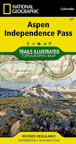
Wandelkaart 127 Aspen - Independence Pass - Colorado USA
Hunter Pass- is a high mountain pass in central Colorado
Korte omschrijving
TOPO Wandelkaart 127 - Aspen - Independence Pass - Colorado USA Productomschrijving: Independence Pass in Aspen Colorado is een uitmuntende wandellocatie. Deze omvat een topografische wandel...

Specificaties
- Uitgever: National Geographic
- ISBN-13: 9781566953580
- HOOFDCATEGORIEËN: Wandelkaart
- Activiteiten: Wandelen, Hiking & Trekking
- Regio: Colorado, USA
- Land: Verenigde Staten van Amerika (USA)
- Schaal: 1:40000
- Afmeting: 10x19
- Taal: Engels
Volledige omschrijving
TOPO Wandelkaart 127 - Aspen - Independence Pass - Colorado USA
Productomschrijving: Independence Pass in Aspen Colorado is een uitmuntende wandellocatie. Deze omvat een topografische wandelkaart die echt tot de verbeelding spreekt. Een subliem exemplaar als het over wandelen gaat.
Engelse omschrijving: Independence Pass, originally known as Hunter Pass, is a high mountain pass in central Colorado, United States. It is at elevation 3,687 m on the Continental Divide in the Sawatch Range of the Rocky Mountains. The pass is midway between Aspen and Twin Lakes, on the border between Pitkin and Lake counties.
National Geographic's Trails Illustrated map of Aspen and Independence Pass delivers unmatched detail and valuable information to assist you in your exploration of this breathtaking region of Colorado. Created in partnership with local land management agencies, this expertly researched map features key areas of interest including Roaring Fork River; Twin Lakes; Independence, Taylor, and Midway passes; and Aspen and Buttermilk ski areas. Portions of Maroon Bells - Snowmass, Hunter - Fryingpan, Mount Massive, Collegiate Peaks, and Spruce Creek wilderness areas and White River, Gunnison, and San Isabel national forests are included as well.
The Aspen and Independence Pass map can guide you off the beaten path and back again with miles of mapped trails including segments of the Continental Divide and Colorado trails. Hiking, cross country ski, snowmobile, and bike trails are clearly marked, and trail mileage between intersections will help you choose the path that's right for you. The Top of the Rockies scenic byway is noted for those wishing to take in the scenery by car. The map base includes contour lines and elevations for summits and passes. Some of the recreation features shown are campgrounds, picnic areas, interpretive sites, fishing areas, trailheads, and points of interest.
Every Trails Illustrated map is printed on "Backcountry Tough" waterproof, tear-resistant paper. A full UTM grid is printed on the map to aid with GPS navigation. Other features found on this map include: Castle Peak, Collegiate Peaks Wilderness, Continental Divide, Gunnison National Forest, Hunter-Fryingpan Wilderness, Independence Pass, La Plata Peak, Maroon Bells-Snowmass Wilderness, Mount Elbert, Mount Massive, Mount Massive Wilderness, San Isabel National Forest, White River National Forest, Williams Mountains.
Locatie op kaart
Overzichtskaarten

NAT GEO Colorado trail maps
NAT GEO Colorado trail maps

Producten op de overzichtskaart
Klik op een product om naar de detailpagina te gaan.
- Wandelkaart 110 Leadville & Fairplay - Colorado - Nat Geo
- Wandelkaart 127 Aspen - Independence Pass - Colorado USA
- Wandelkaart 137 Pikes Peak & Cañon City - Nat Geo
- Wandelkaart 138 Sangre de Cristo Mountains - Nat Geo
- Wandelkaart 139 La Garita Caldera - Cochetopa - Nat Geo
- Wandelkaart 140 Weminuche Wilderness Colorado USA - Nat Geo
- Wandelkaart 141 Telluride- Silverton- Ouray & Lake City - Nat Geo
- Wandelkaart 144 Durango & Cortez- Colorado - Natgeo
- Wandelkaart 200 Rocky Mountain NP- Colorado - Nat Geo
- Wandelkaart 208 Colorado National Monument - Natgeo
- Wandelkaart 245 Black Canyon of the Gunnison NP - Natgeo
- Wandelkaart 301 Longs Peak -Trails Illustrated N. Trails - Nat Geo
- Wandelkaart 601 Aspen Local Trails - Nat Geo
Artikelen uit dezelfde regio

Wandelkaart 1303 Colorado 14ers- Zuid - Nat geo • 9781566957007
TOPO Wandelkaart 1303 - Colorado 14ers- Zuid - Natgeo Productomschrijving: De colorad 14'ers Zuid, zijn de 14 meest indrukwekkende bergmassieven in het zuiden van Colorado. De locatie is onderverdeeld in drie regio's zoals: De Elk Range, San Juan Range & Sangre De Cristo Range. Elk Range: Capitol Peak, Castle Peak, Conundrum Peak, Maroon Peak, North Maroon Peak, Pyramid Peak, Snowmass …

Wandelkaart 200 Rocky Mountain NP- Colorado - Nat Geo • 9781566953429
TOPO Wandelkaart 200 - Rocky Mountain NP- Colorado - National Geographic Productomschrijving: Rocky Mountain National Park is een Amerikaans nationaal park in de Southern Rocky Mountains in het noorden van de staat Colorado. Rocky Mountain National Park bezit majestueuze berggezichten, gevarieerde klimaten en omgevingen – van bossen tot bergtoendra – en makkelijk te bereiken wandelroutes e…

Wandelkaart 104 Idaho Springs & Loveland Pass - Nat Geo • 9781566952491
Wandelkaart Idaho Springs & Loveland Pass Colorado Productomschrijving: Deskundig onderzocht en gemaakt in samenwerking met lokale landbeheerders, biedt National Geographic's Trails Illustrated kaart van Idaho Springs, Loveland Pass een ongeëvenaard hulpmiddel voor het verkennen van deze schilderachtige regio. Ongeacht het seizoen, zult u deze kaart handig vinden voor het uitoefenen van e…

Wandelkaart 1304 Colorado Backpack Loops- Noord - Natgeo • 9781566957557
TOPO Wandelkaart 1304 - Colorado Backpack Loops- Noord - Natgeo Productomschrijving: Colorado is gelend voor zijn outdoor recreatrieve opportuniteiten. Eén van deze bezigheden is uiteraard backcountry & hiking. De Colorado Backpack Loops North Topographic Map Guide omavt de dozijn aan cirkelvormige wandelroutes geselecteerd door het personeel van National Geographic voor hun diversiteit, h…

Wandelkaart 103 Winter Park, Central City & Rollins Pass • 9781566952767
Wandelkaart Winter Park, Central City & Rollins Pass Productomschrijving: National Geographic's Trails Illustrated kaart van Winter Park, Central City en Rollins Pass biedt ongeëvenaarde details voor outdoor enthousiastelingen die het hele jaar door willen genieten van de recreatieve mogelijkheden in de zuidelijke delen van Roosevelt en Arapaho National Forest. Deskundig onderzocht en gema…