

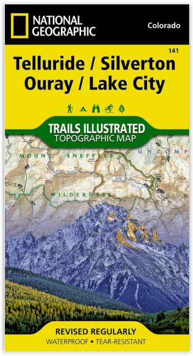
Wandelkaart 141 Telluride- Silverton- Ouray & Lake City - Nat Geo
Met Uncompahgre Wilderness & Alpine Loop National Scenic Byway
Korte omschrijving
Wandelkaarten Colorado, USA van National Geographic. Ideaal voor tochten in Verenigde Staten van Amerika (USA).
Wandelkaart Telluride- Silverton- Ouray & Lake City - Nat Geo Productomschrijving: De National Geographic Trails Illustrated kaart van Telluride, Silverton, Ouray, en Lake City is deskundig ...

Specificaties
- Uitgever: National Geographic
- ISBN-13: 9781566953405
- HOOFDCATEGORIEËN: Wandelkaart
- Activiteiten: Wandelen, Hiking & Trekking
- Auteur: National Geographic
- Regio: Colorado, USA
- Land: Verenigde Staten van Amerika (USA)
- TOPO's & Stafkaarten: Topografisch wandelen
- Schaal: 1:63360
- Taal: Engels
Volledige omschrijving
Wandelkaart Telluride- Silverton- Ouray & Lake City - Nat Geo
Productomschrijving: De National Geographic Trails Illustrated kaart van Telluride, Silverton, Ouray, en Lake City is deskundig onderzocht en gemaakt in samenwerking met lokale landbeheerders. Het is een ongeëvenaard hulpmiddel voor het verkennen van deze adembenemende regio van Colorado. Ongeacht het seizoen is deze kaart een handig hulpmiddel bij een groot aantal recreatieve activiteiten, van skiën, sneeuwscooteren en ijsklimmen tot kamperen, vissen, mountainbiken en ATV-en.
Omvat: de Uncompahgre Wilderness, Alpine Loop National Scenic Byway, Lizard Head Wilderness, Ridgway State Park, Mount Sneffels Wilderness, and San Juan Skyway National Scenic Byway.
Engelse omschrijving: Expertly researched and created in partnership with local land management agencies, National Geographic's Trails Illustrated map of Telluride, Silverton, Ouray, and Lake City provides an unparalleled tool for exploring this breathtaking region of Colorado.
Whatever the season, you'll find this map a useful tool in pursuing a host of recreational activities from skiing, snowmobiling, and ice climbing to camping, fishing, mountain biking, and ATVing. The map also includes information about these featured attractions: Uncompahgre Wilderness, Alpine Loop National Scenic Byway, Lizard Head Wilderness, Ridgway State Park, Mount Sneffels Wilderness, and San Juan Skyway National Scenic Byway.
This map can guide you off the beaten path and back again with miles of mapped trails including the Colorado Trail and the Continental Divide Trail. The map base includes contour lines and elevations for summits and passes. Recreation features such as campgrounds, boat launches, and fishing access are clearly noted, and contact information for various agencies is included as well.
Every Trails Illustrated map is printed on "Backcountry Tough" waterproof, tear-resistant paper. A full UTM grid is printed on the map to aid with GPS navigation.
Other features found on this map include: Cimarron Ridge, El Diente Peak, Gunnison National Forest, Handies Peak, Lizard Head Wilderness, Mount Sneffels, Mount Sneffels Wilderness, Mount Wilson, Redcloud Peak, Rio Grande National Forest, San Juan National Forest, Sunshine Peak, Uncompahgre National Forest, Uncompahgre Peak, Uncompahgre Wilderness, Weminuche Wilderness, Wetterhorn Peak, Wilson Peak.
Locatie op kaart
Overzichtskaarten
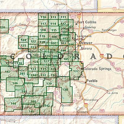
NAT GEO Colorado trail maps
NAT GEO Colorado trail maps
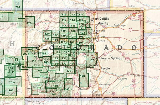
Producten op de overzichtskaart
Klik op een product om naar de detailpagina te gaan.
- Wandelkaart 110 Leadville & Fairplay - Colorado - Nat Geo
- Wandelkaart 127 Aspen - Independence Pass - Colorado USA
- Wandelkaart 137 Pikes Peak & Cañon City - Nat Geo
- Wandelkaart 138 Sangre de Cristo Mountains - Nat Geo
- Wandelkaart 139 La Garita Caldera - Cochetopa - Nat Geo
- Wandelkaart 140 Weminuche Wilderness Colorado USA - Nat Geo
- Wandelkaart 141 Telluride- Silverton- Ouray & Lake City - Nat Geo
- Wandelkaart 144 Durango & Cortez- Colorado - Natgeo
- Wandelkaart 208 Colorado National Monument - Natgeo
- Wandelkaart 245 Black Canyon of the Gunnison NP - Natgeo
Artikelen uit dezelfde regio

Wandelkaart 220 Dinosaur National Monument - Natgeo • 9781566954037
TOPO Wandelkaart 220 - Dinosaur National Monument - Nat Geo Productomschrijving: Dinosaur National Monument in de United States, gelegen op de zuidoostelijke kant van de Uinta Mountains op de grens tussen Colorado en Utah met invloeden van de Green & Yampa Rivieren. Ondanks dat het grootste deel ervan gelegen is in Moffat County, Colorado, is Dinosaur gelegen in Utah net ten noorden van de…

Wandelkaart 1304 Colorado Backpack Loops- Noord - Natgeo • 9781566957557
TOPO Wandelkaart 1304 - Colorado Backpack Loops- Noord - Natgeo Productomschrijving: Colorado is gelend voor zijn outdoor recreatrieve opportuniteiten. Eén van deze bezigheden is uiteraard backcountry & hiking. De Colorado Backpack Loops North Topographic Map Guide omavt de dozijn aan cirkelvormige wandelroutes geselecteerd door het personeel van National Geographic voor hun diversiteit, h…
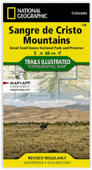
Wandelkaart 138 Sangre de Cristo Mountains - Nat Geo • 9781566953511
Sangre de Cristo Mountains - Great Sand Dunes NP & Preserve Productomschrijving: Verken de kroon van de zuidelijke Rockies en het wonder van de Great Sand Dunes met National Geographic's Trails Illustrated kaart van Sangre de Cristo Mountains. Gemaakt in samenwerking met lokale land management agentschappen, deze deskundig onderzochte kaart levert ongeëvenaarde details en nuttige informati…

Reisgids Colorado USA - Insight Guides (ENG) • 9781839053795
Reisgids Colorado - Insight Guides (ENG) Productomschrijving: From deciding when to go, to choosing what to see when you arrive, this guide to Colorado is all you need to plan your perfect trip, with insider information on must-see, top attractions like Denver Art Museum, Pikes Peak and the Old Fort National Historic Site, and cultural gems like the serrated alpine peaks of the Rocky Mount…
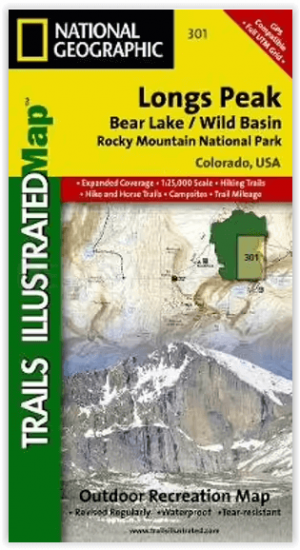
Wandelkaart 301 Longs Peak -Trails Illustrated N. Trails - Nat Geo • 9781566954310
Wandelkaart 301 Longs Peak - Nat Geo Productomschrijving: Engelse omschrijving: Towering over the Rocky Mountains stands the 14,259 foot high Longs Peak. National Geographic's Trails Illustrated map of Longs Peak and the surrounding south-east areas of Rocky Mountain National Park is designed to meet the needs of those who are looking for a phenomenal climbing experience as well as fo…