
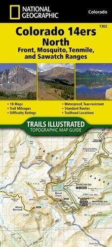
Wandelkaart 1302 Colorado 14'ers- Noord - Nat geo
14 Van de meest indrukwekkende bergmassieven in Colorado
Korte omschrijving
TOPO Wandelkaart 1302 - Colorado 14'ers- Noord - Natgeo Productomschrijving: De Colorado 14'ers bestaat uit 14 van de meest indrukwekkende bergmassieven in Colorado, verdeeld over drie versc...

Specificaties
- Uitgever: National Geographic
- ISBN-13: 9781566956994
- HOOFDCATEGORIEËN: Wandelkaart
- Regio: Colorado, USA
- Land: Verenigde Staten van Amerika (USA)
- Blz.: 48
- Schaal: 1:63360
- Afmeting: 10x19, 11x24
- Taal: Engels
Volledige omschrijving
TOPO Wandelkaart 1302 - Colorado 14'ers- Noord - Natgeo
Productomschrijving: De Colorado 14'ers bestaat uit 14 van de meest indrukwekkende bergmassieven in Colorado, verdeeld over drie verschillende regio's als Front Range, Momsquito Tenmile Ranges en de Sawatch Range. een indrukwekkende locatie om te gaan trekken uiteraard.
Front Range: Mount Bierstadt, Mount Evans, Grays Peak, Longs Peak, Pikes Peak, Torreys Peak
Mosquito, Tenmile Ranges: Tenmile Ranges: Mount Bross, Mount Cameron*, Mount Democrat, Mount Lincoln, Quandary Peak, Mount Sherman
Sawatch Range: Mount Antero, Mount Belford, Mount Columbia, Mount Elbert, Mount Harvard, Mt of the Holy Cross, Huron Peak, La Plata Peak, Mount Massive, Missouri Mountain, Mount Oxford, Mount Princeton, Mount Shavano, Tabeguache Peak, Mount Yale
Engelse omschrijving: Colorado has the highest mean elevation of any state in the United States. It's home to 58 mountain peaks higher than 14,000 feet—more than any other state in the U.S—making it a mountain sports mecca. "Bagging" these fourteeners is a goal for many Coloradans and visitors to the state—and for some, it's an obsession.
The Colorado 14ers North Topographic Map Guide provides the most accurate and convenient set of maps for the fourteeners of the Front, Mosquito, Tenmile, and Sawatch ranges of northern Colorado. Almost half of Colorado's fourteeners fall in these ranges, but their proximity to large population centers leave no shortage of hikers on their slopes. Moderate ridges, established trails, and accessible trailheads are the norm on the standard routes, making many of these peaks relatively easy to climb.
However, it's important to note that these seemingly gentle giants also have their rugged side—including the north face of Mount Evans, the amphitheater north of Mount Democrat, Ellingwood Ridge on La Plata Peak, and the sheer east face of Longs Peak—placing them among the most challenging alpine experiences in the United States. More convenient and easier to use than folded maps, but just as compact and lightweight, National Geographic's Topographic Map Guide booklets are printed on "Backcountry Tough" waterproof, tear-resistant paper with stainless steel staples.
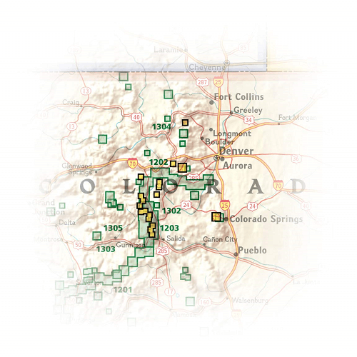
Locatie op kaart
Artikelen uit dezelfde regio

Wandelkaart 144 Durango & Cortez- Colorado - Natgeo • 9781566954631
TOPO Wandelkaart 144 - Durango & Cortez- Colorado - Natgeo Productomschrijving: Deze kaart biedt u alle soorten routes aan in de regio tussen Durango & Cortez in Colrado. UIteraard hebben wij het hier over de wandelroutes, maar eveneens kan er hier aan moutainbiken worden gedaan, of paardrijden op dezelfde routes. Engelse omschrijving: National Geographic's Trails Illustrated map of D…

Reisgids USA Southwest & National Parks - DK Eyewitness • 9780241365519
USA Southwest & National Parks Omvat: Arizona, Las Vegas, Southern Utah, the Four Corners & New Mexico. Productomschrijving: Staar naar de diepten van de Grand Canyon, ervaar de glitter en glamour van de Las Vegas strip, beklim de rotsachtige overspanningen van Arches National Park of wandel door het historische Santa Fe: alles wat u moet weten is overzichtelijk weergegeven in kleurgec…

Wandelkaart 200 Rocky Mountain NP- Colorado - Nat Geo • 9781566953429
TOPO Wandelkaart 200 - Rocky Mountain NP- Colorado - National Geographic Productomschrijving: Rocky Mountain National Park is een Amerikaans nationaal park in de Southern Rocky Mountains in het noorden van de staat Colorado. Rocky Mountain National Park bezit majestueuze berggezichten, gevarieerde klimaten en omgevingen – van bossen tot bergtoendra – en makkelijk te bereiken wandelroutes e…

Wandelkaart 141 Telluride- Silverton- Ouray & Lake City - Nat Geo • 9781566953405
Wandelkaart Telluride- Silverton- Ouray & Lake City - Nat Geo Productomschrijving: De National Geographic Trails Illustrated kaart van Telluride, Silverton, Ouray, en Lake City is deskundig onderzocht en gemaakt in samenwerking met lokale landbeheerders. Het is een ongeëvenaard hulpmiddel voor het verkennen van deze adembenemende regio van Colorado. Ongeacht het seizoen is deze kaart een h…

Wandelkaart 137 Pikes Peak & Cañon City - Nat Geo • 9781566953986
Pikes Peak & Cañon City Colorado - National Geographic Productomschrijving: De hoogste top in de zuidelijke Front Range van de Rocky Mountains, Pikes Peak torent boven Colorado Springs uit als een granieten schildwacht. Verken deze en andere geologische attracties zoals Garden of the Gods, Florrisant Fossil Beds en de Royal Gorge met National Geographic's Trails Illustrated kaart van Pikes…