

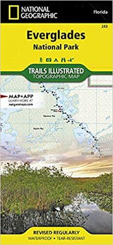
Wandelkaart 243 Everglades NP- Florida - Natgeo
Het park is het grootste nationaal tropische wildernes in de USA
Korte omschrijving
Wandelkaarten Florida, USA van National Geographic. Ideaal voor tochten in Verenigde Staten van Amerika (USA).
TOPO Wandelkaart 243 - Everglades NP- Florida - Nat Geo Productomschrijving: Everglades Nationaal Park is een Ameriaaks nationaal park die de zuidelijke 20% beschermt van de originele Evergl...

Specificaties
- Uitgever: National Geographic
- ISBN-13: 9781566954099
- HOOFDCATEGORIEËN: Wandelkaart
- Activiteiten: Wandelen, Hiking & Trekking
- Auteur: National Geographic
- Regio: Florida, USA
- Land: Verenigde Staten van Amerika (USA)
- Nationale parken: Everglades NP, Florida USA
- TOPO's & Stafkaarten: Topografisch wandelen
- Schaal: 1:100000
- Taal: Engels
Volledige omschrijving
TOPO Wandelkaart 243 - Everglades NP- Florida - Nat Geo
Productomschrijving: Everglades Nationaal Park is een Ameriaaks nationaal park die de zuidelijke 20% beschermt van de originele Everglades in Florida. Het park is het grootste nationaal tropische wilderness in de United States, en het grootste wildpark ten oosten van de Mississippi River. Een dikke anderhalf milioen mensen bezoeken het park elk jaar opnieuw.
Engelse omschrijving: Visited by more than 1 million people a year, Everglades National Park has one of the world's most diverse ecosystems and is an international treasure. Outdoor enthusiasts exploring this unique and fragile environment will marvel at National Geographic's Trails Illustrated map of the park. Created in cooperation with the National Park Service and others, this expertly researched map covers not only the park, but also parts of neighboring John Pennekamp Coral Reef State Park, Big Cypress National Preserve and Cape Romano Ten Thousand Islands Aquatic Preserve, as well as Everglades City and Key Largo. Inset maps provide extensive detail of Flamingo, Whitewater Bay, Pineland Trails of the Long Pine Key area and Nine Mile Pond.
Mapped canoes trails will guide you through the area's bays, lakes and other waterways. The 99-mile Wilderness Waterway is mapped in its entirety along with its NPS markers, backcountry campsites and chickees. The Whitewater Bay area additionally shows Coast Guard markers, sounding depths and sub-surface conditions. Those exploring on foot can enjoy mapped hiking trails, many displaying mileage markers. To aid in your navigation, the map displays areas of mangroves, hardwood hammocks and wooded cover, marshes, sawgrass prairies, wildlife protection areas, selected waypoints and clear color-coded national park, national preserve and state park boundaries. Additional recreation features and facilities pinpointed include marinas, boat launch areas, bike trails, interpretive trails, showers and restrooms. Every Trails Illustrated map is printed on "Backcountry Tough" waterproof, tear-resistant paper. A full UTM grid is printed on the map to aid with GPS navigation.
Other features found on this map include: Barnes Sound, Big Cypress, Cape Sable, Everglades, Florida Bay, Ponce de León Bay, Ten Thousand Islands, Whitewater Bay.
.jpg)
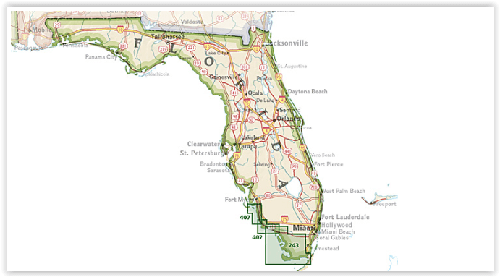
Overzichtskaarten

NAT GEO Florida trails map
NAT GEO Florida trails map

Producten op de overzichtskaart
Klik op een product om naar de detailpagina te gaan.
Artikelen uit dezelfde regio

Reisgids Floride Florida 2025-2026 - Petit Futé • 9782305122397
Reisgids Floride 25-26 - Petit Futé Productomschrijving: La Floride, installée sur des marais, est le royaume de l'incertain. elle est imprévisible à l'image de la platitude de son horizon, parfois balayé par un ouragan. Villégiature et high-tech y font bon ménage avec les parcs d'attraction qui ne cessent de s'y développer. On ne risque pas de s'y ennuyer et la nature est bien là, même si…

Reisgids Floride - Le Routard • 9782017068242
Floride du Routard Déscription de produits: Le Routard, le meilleur compagnon de voyage depuis 45 ans. Dans cette nouvelle édition du Routard Floride vous trouverez une première partie en couleurs avec des cartes et des photos, pour découvrir plus facilement la région et repérer nos coups de coeur, des suggestions d'itinéraires et des informations pratiques pour organiser votre séjour,…

Reeisgids Floride Florida 2026-2027 - Le Routard • 9782017338260
Reeisgids Floride - Le Routard Productomschrijving: Le Routard, le meilleur compagnon de voyage depuis 45 ans. Dans cette nouvelle édition du Routard Floride vous trouverez une première partie en couleurs avec des cartes et des photos, pour découvrir plus facilement la région et repérer nos coups de coeur, des suggestions d'itinéraires et des informations pratiques pour organiser votre séj…

Stadskaart plattegrond Miami Florida USA - Borch • 9783866091511
Wandelkaart Miami Florida USA - Borch Productomschrijving: Our soft-laminated folded map of Miami in the 11th edition shows: Miami Downtown 1:15 000, Miami Beach 1:15 000, Coconut Grove 1:15 000, Greater Miami 1:350 000, Southern Florida 1:500 000, Coral Gables 1:30 000, Public Transportation Miami, Top 30 Sights, USA administrative & time zones. Borch Maps are easy to fold, durable and wa…

Reisgids Florida - DK Eyewitness • 9780241365489
Reisgids Florida - DK Eyewitness Productomschrijving: Take a ride on one of the state's world-famous roller coasters, uncover the secrets of the Kennedy Space Centre or lounge on a tropical beach: everything you need to know is clearly laid out within colour-coded chapters. Discover the best of Florida with this indispensable travel guide. Covers: Miami, the Gold and Treasure coasts, O…