

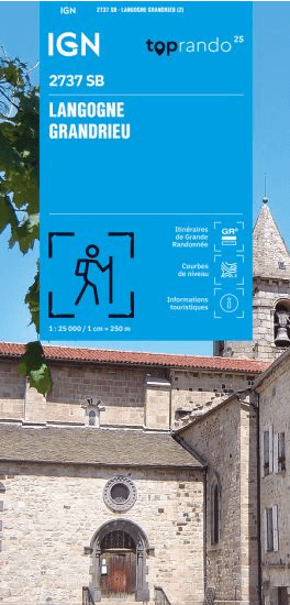
Wandelkaart 2737 SB Langogne & Grandrieu - IGN
Saint-Étienne-du-Vigan- Cheylard-l'Évêque- Saint-Alban-en-Montagn

Korte omschrijving
Wandelkaarten Occitanië, Frankrijk van Institut Géographique National. Ideaal voor tochten in Frankrijk.
Wandelkaart Langogne & Grandrieu - IGN Productomschrijving: Deze omvat de Nouvelle Serie Blue (SB) NIET topografische wandelkaarten van IGN, met daarop: Langogne & Grandrieu, Saint-Étienne-d...

Specificaties
- Uitgever: Institut Géographique National
- ISBN-13: 9782758556985
- HOOFDCATEGORIEËN: Wandelkaart
- Activiteiten: Wandelen, Hiking & Trekking
- Regio: Occitanië, Frankrijk
- Land: Frankrijk
- Departement: Ardèche (07), Lozère (48)
- Schaal: 1:25000
- Editie: 2
- Taal: Frans
- Reeks/Serie: IGN Cartes Série Bleue
- De Franse Regio's: Occitanië
Volledige omschrijving
Wandelkaart Langogne & Grandrieu - IGN
Productomschrijving: Deze omvat de Nouvelle Serie Blue (SB) NIET topografische wandelkaarten van IGN, met daarop: Langogne & Grandrieu, Saint-Étienne-du-Vigan, Cheylard-l'Évêque, Saint-Alban-en-Montagne, enz...
Omvat: Langogne, Saint-Étienne-du-Vigan, Cheylard-l'Évêque, Saint-Alban-en-Montagne, Saint-Paul-de-Tartas, Grandrieu, Saint-Arcons-de-Barges, Naussac-Fontanes, Rocles, Lavillatte, Saint-Jean-la-Fouillouse, Coucouron, Auroux, Lespéron, Rauret, Saint Bonnet-Laval, Chastanier
Te ontdekken: Parc Naturel Régional des Monts d'Ardèche, Réservoir de Naussac, Mont de la Bruyère, Monts de la Margeride, Musée de la filature, Monument à Du Guesclin, Pierre Branlante, Cascade du Donozau
Afmeting: 96 cm x 132 cm
L'indispensable carte de randonnée ! Ces cartes topographiques d'une très grande précision contiennent tous les détails existant sur le terrain, les sentiers balisés et des informations touristiques. Sans oublier la représentation du relief par des courbes de niveau.

Overzichtskaarten

IGN TOP25 Wandelkaarten Cantal en Auvergne Zuid
IGN TOP25 Wandelkaarten Cantal en Auvergne Zuid
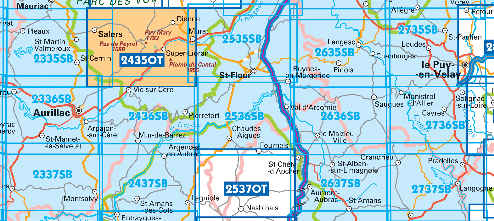
Producten op de overzichtskaart
Klik op een product om naar de detailpagina te gaan.
- Wandelkaart 2335 SB Pleaux- St-Cernin & Salers - IGN
- Wandelkaart 2336 SB Aurillac & Laroquebrou - IGN
- Wandelkaart 2337 SB Montsalvy - IGN
- Wandelkaart 2435 OT Monts du Cantal - IGN
- Wandelkaart 2436 SB Vic-sur-Cère & Pierrefort - IGN
- Wandelkaart 2437 SB Laguiole & Entraygues-sur-Truyère - IGN
- Wandelkaart 2535 SB Saint-Flour & Murat - IGN
- Wandelkaart 2536 SB Chaudes-Aigues - IGN
- Wandelkaart 2537 OT Nasbinals & Monts d'Aubrac - IGN
- Wandelkaart 2635 SB Langeac & Lavoûte-Chilhac - IGN
- Wandelkaart 2636 SB Saugues - IGN
- Wandelkaart 2637 SB St-Chély-d'Apcher - IGN
- Wandelkaart 2735 SB Le Puy-en-Velay & Loudes - IGN
- Wandelkaart 2736 SB Solignac-sur-Loire & Cayres - IGN
- Wandelkaart 2737 SB Langogne & Grandrieu - IGN
Artikelen uit dezelfde regio
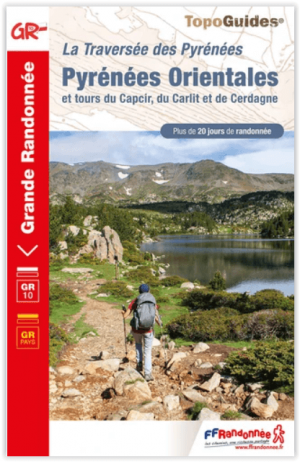
Wandelgids 1092 La traversée des Pyrénées Orientales - FFR • 9782751412431
La traversée des Pyrénées Orientales - FFR Productomschrijving: Meer dan 20 dagen wandelen, waarvan 12 dagen van Banyuls naar Mérens-les-Vals. Inbegrepen: van Fenouillèdes tot Bourg-Madame. Tussen de hoge toppen van de Carlit op bijna 3000 meter, de grensketen en het mythische Canigou-massief, tussen de zee en de uitlopers van de Fenouillèdes en de Corbières, verdienen de Pyrénées-Orie…

Wandelgids Hautes-Pyrénées- Haut-Adour- Aure & Louron • 9782844662965
Hautes-Pyrénées- Haut-Adour- Aure & Louron Productomschrijving: Een nauwe relatie tussen de teksten, de cartografie en de beelden, om alle belangrijke sites van de Haut Adour, de Aure en Louron valleien te bestrijken. De uitlopers van de Pic du Midi de Bigorre, het massief van Néouvielle, de grensruggen en de grote mythische passen zoals Aspin, Tourmalet of Peyresourde. 20 hoogtewandelinge…
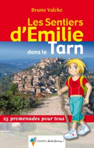
Wandelgids le Tarn - Rando • 9782841824175
Les Sentiers d'Emilie dans le Tarn - 25 Balades pour tous Productomschrijving: Deze wandelgids, biedt u een mooi overzicht over de wandelroutes in één van Frankrijks mooiste gebieden, "le Tarn", en dat in de reeks van "Les Sentier d'Emilie", een reeks die u nooit onbewogen laat, welke gids u ook kiest. Deze gids biedt u 25 prachtige uitgezochte routes, samengesteld door mensen die de route…


Wandelkaart 2238 SB Figeac & Cajarc - IGN • 9782758546191
Wandelkaart 2238 SB - Figeac & Cajarc Productomschrijving: Figeac & Cajarc zijn Franse gemeente gelegen pal naast het regionale park, in de regio Occitanie, en is op één na grootste gemeente in het departement Lot. Productomschrijving: Tussen 2014 en 2018 vernieuwt IGN haar volledige collectie serie blauw. Een nieuwe toewijzing voor optimale leesbaarheid, met een grotere mate van geome…

Wandelkaart 1944 SB Samatan Lombez & L'Isle-en-Dodon - IGN • 9782758541455
Wandelkaart 1944 SB - Samatan Lombez & L'Isle-en-Dodon Productomschrijving: Samatan Lombez & L'Isle-en-Dodon zijn gemeentes in het Franse departement Haute-Garonneregio in de regio Occitanie. De plaats maakt deel uit van het arrondissement Auch. Een gloed nieuwe reeks IGN kaarten: de oude versies met de Est en Ouest (E en O aanduiding achter het nummer van de kaart) verdwijnen en word…