

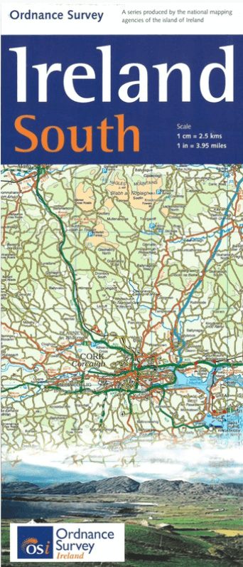
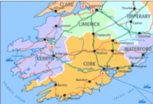
Landkaart Wegenkaart H4 Ierland Zuid - OSI
Ireland South Road map

Korte omschrijving
Wegenkaart Zuid Ierland Zuid - OSI Productomschrijving: Ordnance Survey Ireland South Road map at 1:250,000 approx 4 miles to the Inch. This map shows detailed road classification, alti...

Specificaties
- Uitgever: Ordnance Survey Ireland
- ISBN-13: 9781908852861
- HOOFDCATEGORIEËN: Wegenkaart - Landkaart
- Activiteiten: Street/Road maps & city plans
- Regio: Ierland, Zuid ierland
- Land: Ierland
- Schaal: 1:250000
- Taal: Engels
- Reeks/Serie: Discovery Series, OSI
Volledige omschrijving
Wegenkaart Zuid Ierland Zuid - OSI
Productomschrijving: Ordnance Survey Ireland South Road map at 1:250,000 approx 4 miles to the Inch.
This map shows detailed road classification, altitude colouring and tourist information, published by OSI, the Ordnance Survey of Ireland.
Topography of the island is shown by altitude colouring, with additional spot heights and names of mountain or hill ranges and other geographical features. Additional graphics show different types of woodlands etc. Road network shows six grades of roads; Railway lines are shown with stations.
A range of symbols highlights camping and caravan sites, nature reserves, National Trust and An Taisce properties or land, golf courses (indicating the number of holes), historical sites, etc.

Artikelen uit dezelfde regio

Landkaart Wegenkaart 2026 Ireland Road Map - Harper Collins • 9780008719241
Wegenkaart Ireland Road Map - Harper Collins Productomschrijving: Full-colour map of Ireland at 9 miles to 1 inch (1:570,240), with clear, detailed road network and counties and new administrative areas shown in colour. This double-sided map covers the whole of Ireland, and is ideal for reference or route planning. This map of Ireland shows the road network in detail. It is ideal for busin…
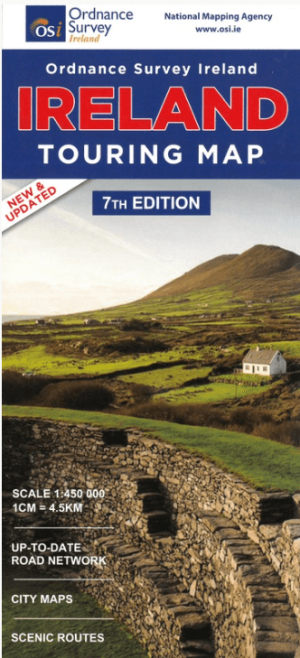
Landkaart Wegenkaart Discovery Ierland touring map - OSI • 9781908852892
Wegenkaart Discovery Ierland touring map - OSI Productomschrijving: A folded map covering the whole of the island of Ireland published by Ordnance Survey Ireland. - Clear easy to read mapping, with tourist information symbols for a variety of attractions - Up to Date Road Network and includes a placename Index. - Includes a Distance Chart in Kms. - Distances in Kms marked across…
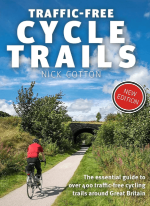
Traffic-Free Cycle Trails around Great Britain - Vertebrate Publ. • 9781912560769
Traffic-Free Cycle Trails around Great Britain - Vertebrate Productomschrijving: The essential guide to over 400 traffic-free cycling trails around Great Britain Traffic-Free Cycle Trails by Nick Cotton contains over 400 cycle routes in Great Britain. This book includes a great variety of routes on former railway paths, canal towpaths and forest trails in England, Scotland and Wales, w…

Wandelgids 100 outstanding British Walks - Ordnance Survey • 9780319090862
100 outstanding British Walks - OS Productomschrijving: Deze gloednieuwe wandelgids van Ordnance Survey, brengt u een hoop prachtige wandelingen over het ganse Britse landschap verdeeld. Onderaan vindt u de lijst, opgedeeld in de verschillende regio's van de Britse eilanden. Engelse omschrijving: This magnificent compendium of outstanding British walks brings together the finest sele…

Reisgids Simpelweg Ierland - Lannoo • 9789401490795
Simpelweg Ierland - Lannoo Productomschrijving: Ierland is in deze gloednieuwe reeks reisgidsen van de uitgever Lannoo, niet in 2 delen verdeeld. Zowel Ierland als Noord Iermand zijn opgenomen in deze prachtige Simpelweg reeks van Lannoo. Omvat: Dublin, Kilkenny, Cork, Killarney, Limerick, Galway, Belfast, Londonderry, Letterkenny, Enniskillen - De mooiste plekken en leukste activi…