

Wandelgids The Cleveland Way & Yorkshire Wolds Way - CIcerone
Cleveland Way - Yorkshire Wolds Way - Tabular Hills Walk
Korte omschrijving
Wandelgidsen Yorkshire, England van CICERONE Press. Ideaal voor tochten in England.
Wandelgids The Cleveland Way & Yorkshire Wolds Way - CIcerone Productomschrijving: De vernieuwede wandelgids over de Cleveland Way en Yorkshire Wolds Way National Trails, plus de Tabular Hil...

Specificaties
- Uitgever: CICERONE Press
- ISBN-13: 9781786312211
- HOOFDCATEGORIEËN: Wandelgids
- Activiteiten: Wandelen, Hiking & Trekking
- Auteur: Paddy Dylan
- Regio: Yorkshire, England
- Land: England
- Nationale parken: North York Moors NP, England
- Editie: 3
- Taal: Engels
- Reeks/Serie: National Trails, UK
- De Engelse Graafschappen: Yorkshire
- National Trails UK, England & Wales: Cleveland Way, England
Volledige omschrijving
Wandelgids The Cleveland Way & Yorkshire Wolds Way - CIcerone
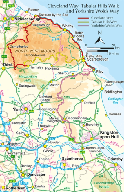
Productomschrijving: De vernieuwede wandelgids over de Cleveland Way en Yorkshire Wolds Way National Trails, plus de Tabular Hills Walk. De drie routes lopen door het North York Moors National Park, langs de kust en op het rustige platteland en kunnen worden samengevoegd tot een gemakkelijke rondwandeling van meer dan 400 km. Inclusief een 1:25.000 schaal OS kaartboekje van de Cleveland Way.
Aparte Map booklet beschikbaar hieronder!
Engelse omschrijving: A walking guidebook to the Cleveland Way and Yorkshire Wolds Way National Trails, plus the Tabular Hills Walk. Crossing the North York Moors National Park, coastal scenery and quiet countryside, the three routes can be joined to create an easy circular route of over 250 miles (400km). Includes a 1:25,000 scale OS map booklet of the Cleveland Way.
Seasons:
All year round, though winter can be bleak and wet on the moors.
Centres:
Scarborough, Whitby, Filey, Helmsley, Osmotherley.
Difficulty:
Suitable for all: the trails are divided into sections ranging from 2½-12 miles. There are some isolated stretches.
Must See:
Yorkshire's Heritage Coast; Ryedale Folk Museum; Rievaulx Abbey; Whitby; historic villages; moorland scenery.
Dorpen & Steden:
Scarborough, Whitby, Filey, Helmsley, Osmotherley
Inhoudsopgave:
The Yorkshire Wolds Way National Trail
Stage 1 Hessle to South Cave
Stage 2 South Cave to Goodmanham or Market Weighton
Stage 3 Goodmanham or Market Weighton to Millington
Stage 4 Millington to Thixendale
Stage 5 Thixendale to Sherburn
Stage 6 Sherburn to Filey
Stage 7 Filey to Scalby Mills (via the Cleveland Way)
The Tabular Hills Walk:
Stage 1 Scalby Mills to Levisham
Stage 2 Levisham to Hutton-le-Hole
Stage 3 Hutton-le-Hole to Helmsley
The Cleveland Way National Trail:
Stage 1 Helmsley to Sutton Bank
Stage 2 Sutton Bank to Osmotherley
Stage 3 Osmotherley to Clay Bank
Stage 4 Clay Bank to Kildale
Stage 5 Kildale to Saltburn-by-the-Sea
Stage 6 Saltburn-by-the-Sea to Sandsend
Stage 7 Sandsend to Robin Hood’s Bay
Stage 8 Robin Hood’s Bay to Scarborough
Stage 9 Scarborough to Filey

Gekoppelde artikelen
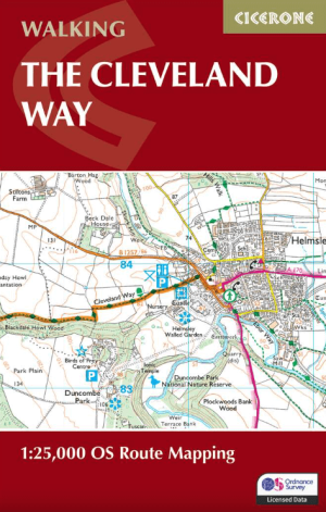
Wandelgids The Cleveland Way Map Booklet - Cicerone • 9781786312228
standaard versieThe Cleveland Way Map Booklet - Cicerone Productomschrijving: Kaartboekje van de Cleveland Way National Trail, een 177 km lange wandeling rond het North York Moors National Park. Dit boekje is inbegrepen bij de Cicerone gids voor de Cleveland Way en de Yorkshire Wolds Way en toont de volledige route van de Cleveland Way op OS 1:25.000 kaarten. Dit kaart Boekje zit reeds gratis bijgevoe…
Artikelen uit dezelfde regio

Wandelgids North Yorkshire historic walks - Cicerone • 9781852843892
Wandelgids - North Yorkshire historic walks - Cicerone Productomschrijving: Een gids over historische wandelingen in North Yorkshire, in 20 meestal circulaire routes. Zij brengen u van open heidegebied en blootgestelde delen van heuvel en kliffen naar de meer beschutte dales en de straten van York. Wandelingen bevatten Skipton Castle, Ripon en Fountains Abbey, Ripley Castle, Castle Howard,…

Reisgids Yorkshire England - Rough Guides • 9781789194159
Reisgids Yorkshire England - Rough Guides Productomschrijving: The Rough Guide to Yorkshire was the first comprehensive guidebook to England’s largest county. Detailed coverage of the ruggedly beautiful Dales and Moors, the magnificent North Sea coast and historic York rubs shoulders with penetrating insights into the multi-cultural cities of Leeds and Sheffield, the resurgent port of Hull…

Wandelkaart 298 Nidderdale AONB- Yorkshire - OSI • 9780319245507
Wandelkaart Nidderdale AONB - Yorkshire England Omvat ook: Fountains Abbey, Ripon & Pateley Bridge Productomschrijving: Kaart nummer 298 in de OS Explorer kaarten serie heeft een oppervlakte van North Yorkshire rond Nidderdale. De Nidderdale way en Ripon Rowel lopen door dit pittoreske gebied, die ook een deel van het Yorkshire Dales National Park heeft. Hoogtepunten van het gebied zij…

Mountainbikegids Yorkshire Dales mountain biking - Cicerone • 9781852846763
Mountainbikegids - Yorkshire Dale mountain biking - Cicerone Productomschrijving: Een handige gids over 30 korte, middellange, lange en volledig-dag MTB routes over het Yorkshire Dales National Park, de speeltuin van de bergfietser van Noord-Engeland. Circulaire ritten bezoeken de grote valleien en nemen lussen rond twee van de drie pieken, Whernside en Pen-y-Gent. Kies een route door midd…

Wandelgids Atlas Yorkshire Dales NP - Harvey maps • 9781851374953
Wandelgids - Atlas Yorkshire Dales NP - Harvey maps Productomschrijving: Deze spiraal gebonden gids/Atlas combineert in één volume, de gedetailleerde kaarten van de Yorkshire Dales, die betrekking hebben op het geheel van het nationaal park en het gebied Midden Dale. De atlas is ontworpen voor gebruik buitenshuis en de pagina's, hoewel niet scheur-proof, worden afgedrukt op waterdichte pap…