

Wandelgids The Cotswold Way Map Booklet - Cicerone
Van Chipping Camden en Bath - 164 km

Korte omschrijving
Wandelgidsen Gloucestershire, Egland en Somerset South West England van CICERONE Press. Ideaal voor tochten in England.
The Cotswold Way - Cicerone Productomschrijving: OPGELET: Dit artikel is reeds inbegrepen in de volledige wandelgids van de The Cotswold Way. Deze kunt u vinden met dit ISBN nr in te geven ...

Specificaties
- Uitgever: CICERONE Press
- ISBN-13: 9781786312112
- HOOFDCATEGORIEËN: Wandelgids
- Activiteiten: Wandelen, Hiking & Trekking
- Auteur: Kevin Renolds
- Regio: Gloucestershire, Egland, Somerset South West England
- Land: England
- Lange afstand wandelroutes: Cotswold Way, England (164km)
- AONB - Area of Outstanding Beauty: Cotswolds AONB
- Schaal: 1:25000
- Editie: 2
- Taal: Engels
- Reeks/Serie: Map Booklet, Cicerone, National Trails, UK
- National Trails UK, England & Wales: Cotswolds Way, England
Volledige omschrijving
The Cotswold Way - Cicerone
Productomschrijving: OPGELET: Dit artikel is reeds inbegrepen in de volledige wandelgids van de The Cotswold Way. Deze kunt u vinden met dit ISBN nr in te geven in onze zoekfunctie: 9781786312105 - Het boek gaat over de befaamde Cotswold Way, tussen Chipping Camden en Bath, dwars door het Cotswolds AONB regio van uitmuntend natuurschoon. 164 km lange route in 2 richtingen te doen, gans het jaar door toegangkelijk.
Engelse omschrijving: Map of the 102 mile (164 km) Cotswold Way National Trail, between Chipping Camden and Bath. This booklet is included with the Cicerone guidebook to the trail, and shows the full route on OS 1:25,000 maps. The trail typically takes two weeks to walk, and is suitable for walkers at all levels of experience.
Seasons:
Can be walked all year round: accommodation is scarce during Cheltenham Festival (March) and Badminton horse trials (late April/May).
Centres:
Chipping Campden, Cheltenham, Gloucester, Stroud, Bath.
Difficulty:
The Cotswold Way is a waymarked lowland walk suitable for all abilities: suggested day sections are in the region of 6-10 miles (10-16km).
Must See:
Hailes Abbey, Belas Knap, Crickley Hill, Haresfield Beacon, Sudley Castle, Broadway, views of Kelston Round Hill, Roman baths (Bath).
Gekoppelde artikelen

Wandelgids The Cotswold Way - Cicerone • 9781786312105
standaard versieThe Cotswold Way - Cicerone Productomschrijving: Wandelgids over de Cotswold Way Nationale route. Tussen Chipping Campden en Bath verkent de 164 km lange route door de Cotswolds AONB (Area of Outstanding Natural Beauty). Beschreven in beide richtingen over 13 etappes. De Cotswold Way kan het hele jaar door belopen worden, en is geschikt voor beginnende wandelaars. Inclusief apart OS 1:25.0…
Artikelen uit dezelfde regio
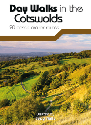
Wandelgids Day Walks in the Cotswolds AONB - Vertebrate Publ. • 9781910240991
Day Walks in the Cotswolds AONB - Vertebrate Productomschrijving: Day Walks in the Cotswolds by Judy Mills features 20 circular routes suitable for hillwalkers of all abilities. Together with stunning photography, each route features Ordnance Survey 1:25,000 maps, easy-to-follow directions, distance and navigation information, refreshment stops and local information. Split across thre…

Wandelgids Cotswold Way - Trailblazer Publications • 9781912716418
The Cotswold Way - Trailblazer Publications Productomschrijving: Chipping Campden tot Bath met 49 maps en 30 kleurfoto's. The Cotswolds Way loopt door het befaamd Cotswold AONB (Area of Outstanding Natural Beauty, of regio van uitmunend natuurschoon. The Cotswold Way, is een zeer goed gekende route van een dikke 164 km lang en biedt alles voor de natuurliefhebber. Engelse omschrijving:…

Reisgids Bath- Bristol & Somerset - Rough Guides • 9781839059841
Bath- Bristol & Somerset - Rough Guides Productomschrijving: De regio van somerset in Zuid west Engeland, biedt u in deze gids de uitlopers van Exmoor nationaal park, Bath, Bristol en de volledige regio Somerset. Engelse omschrijving: From the genteel Georgian terraces of Bath to the wilderness expanses of Exmoor NP, the fully updated The Rough Guide to Bath, Bristol & Somerset provide…

Wandelkaart 142 Shepton Mallet & Mendip Hills - OSI • 9780319243350
Wandelkaart Shepton Mallet & Mendip Hills East - Somerset Omvat ook: Frome & Midsomer Norton. Productbeschrijving: Kaart nummer 142 in de OS Explorer kaarten reeks omvat Midsomer Norton, Frome, Shepton Mallett en Strauss. Hoogtepunten van het gebied zijn onder andere: Westerse Cranbourne Chase AONB en West Wiltshire Downs AONB, het zuidelijkste puntje van de Cotswolds AONB. De rivier d…
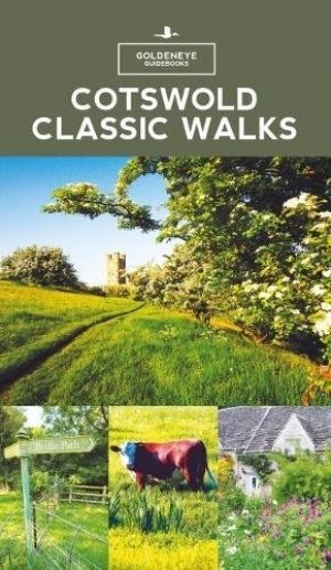
Wandelgids - Cotswold classic walks guidebook - Goldeneye • 9781859652602
Wandelgids Cotswold classic walks guidebook Productomschrijving: In eerste instantie is dit wat de engelsen noemen een AONB, een "Area of Outstanding Natural Beauty" die in deze versie verspreidt word over verschillende regio's aangezien zijn grote. Deze plaats van subliem natuurschoon, ligt deel is, Somerset, deels in wawickshire, deels in Wiltshire, deels in Oxfordshire en is de meest be…