
Wandelkaart 188 Builth Wells & Llanfair-ym-Muallt - OSI
Het bovenste gedeelte van de Wye Valley rond Builth Wells
Korte omschrijving
Wandelkaart Builth Wells & Llanfair-ym-Muallt - Wales Productbeschrijving: Painscastle & Talgarth. 188 / Builth Wells & Llanfair-ym-Muallt, Wales - Kaart nummer 188 in de OS Explorer ka...

Specificaties
- Uitgever: Ordnance Survey
- ISBN-13: 9780319243817
- HOOFDCATEGORIEËN: Wandelkaart
- Activiteiten: Wandelen, Hiking & Trekking
- Regio: Powys, Wales
- Land: Wales
- Schaal: 1:25000
- Afmeting: 13x23
- Taal: Engels
- Reeks: Explorer Series
Volledige omschrijving
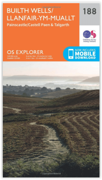
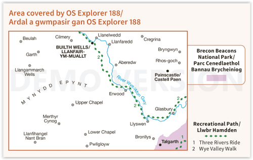
Wandelkaart Builth Wells & Llanfair-ym-Muallt - Wales
Productbeschrijving: Painscastle & Talgarth.
188 / Builth Wells & Llanfair-ym-Muallt, Wales - Kaart nummer 188 in de OS Explorer kaart reeks is ideaal voor het ontdekken van het bovenste gedeelte van de Wye Valley rond Builth Wells. De Wye Valley Walk recreatieve pad slingert zich naast de rivier Wye. Andere hoogtepunten van het gebied zijn: Painscastle, Talgarth en Pwllgloyw. De OS Explorer kaart voor Builth Wells is beschikbaar in zowel de standaard papieren versie als de weerbestendige 'Actief' versie.
188 / Builth Wells & Llanfair-ym-Muallt, Wales - Map sheet number 188 in the OS Explorer map series is ideal for discovering the upper section of the Wye Valley around Builth Wells. The Wye Valley Walk recreational path meanders alongside the river Wye offering exciting terrain to explore. Other highlights of the area include: Painscastle, Talgarth and Pwllgloyw. The OS Explorer map for Builth Wells is available in both the standard paper version and weatherproof 'Active' version.
Locatie op kaart
Gekoppelde artikelen

Wandelkaart 188 Builth Wells & Llanfair-ym-Muallt - OSI • 9780319243817
standaard versieWandelkaart Builth Wells & Llanfair-ym-Muallt - Wales Productbeschrijving: Painscastle & Talgarth. 188 / Builth Wells & Llanfair-ym-Muallt, Wales - Kaart nummer 188 in de OS Explorer kaart reeks is ideaal voor het ontdekken van het bovenste gedeelte van de Wye Valley rond Builth Wells. De Wye Valley Walk recreatieve pad slingert zich naast de rivier Wye. Andere hoogtepunten van het ge…

Wandelkaart 188 Builth Wells & Llanfair-ym-Muallt - OSI • 9780319470602
weatherproof versieWandelkaart Builth Wells & Llanfair-ym-Muallt - Wales Omvat ook: Painscastle & Talgarth. Productbeschrijving: Kaart nummer 188 in de OS Explorer kaarten reeks is ideaal voor het ontdekken van het bovenste gedeelte van de Wye Valley rond Builth Wells. De Wye Valley Walk recreatief pad slingert zich langs de rivier Wye en beloofd een spannend terrein te zijn voor het verkennen. Andere ho…
Overzichtskaarten

OSI Explorer & Explorer Active - Wales
OSI Explorer & Explorer Active - Wales

Producten op de overzichtskaart
Klik op een product om naar de detailpagina te gaan.
- Wandelkaart 151 Cardiff & Bridgend- Wales - OSI
- Wandelkaart 152 Newport & Pontypool- South Wales - OSI
- Wandelkaart 164 Gower AONB & Gwyr- South Wales - OSI
- Wandelkaart 165 Swansea & Abertawe- South Wales - OSI
- Wandelkaart 166 Rhondda & Merthyr Tydfil - OSI
- Wandelkaart 177 Carmarthen & Kidwelly- Wales - OSI
- Wandelkaart 178 Llanelli- Ammanford & Rhydaman - OSI
- Wandelkaart 185 Newcastle & Emly- Northumberland - OSI
- Wandelkaart 186 Llandeilo- Brechfa Forest- Wales - OSI
- Wandelkaart 187 Llandovery- South Wales - OSI
- Wandelkaart 188 Builth Wells & Llanfair-ym-Muallt - OSI
- Wandelkaart 189 Hereford & Ross-on-Wye- England - OSI
- Wandelkaart 198 Cardigan & New Quay- Wales - OSI
- Wandelkaart 199 Lampeter- Wales - OSI
- Wandelkaart 200 Llandrindod Wells & Elan Valley - OSI
- Wandelkaart 201 Knighton & Presteigne- Wales - OSI
- Wandelkaart 202 Leominster & Bromyard Hererfordshire - OSI
- Wandelkaart 203 Ludlow & Shropshire Hills AONB - OSI
- Wandelkaart 213 Aberystwyth & Cwm Rheidol - Wales - OSI
- Wandelkaart 214 Llanidloes- Newtown & Y Drenewydd - OSI
- Wandelkaart 215 Newtown & Machynlleth- Powys Wales - OSI
- Wandelkaart 216 Welshpool & Montgomery- Powys - OSI
- Wandelkaart 217 Long Mynd & Wenlock Edge - OSI
- Wandelkaart 239 Lake Vyrnwy & Efyrnwy- North Wales - OSI
- Wandelkaart 240 Oswestry & Croesoswallt- Shropshir - OSI
- Wandelkaart 241 Shrewsbury- shropshire England - OSI
- Wandelkaart 253 Lleyn Peninsula West Wales - OSI
- Wandelkaart 254 Lleyn Peninsula East- Wales - OSI
- Wandelkaart 255 Llangollen & Berwyn- West Wales - OSI
- Wandelkaart 256 Wrexham- Wrecsam & Llangollen - OSI
- Wandelkaart 257 Crewe & Nantwich & Cheshire East - OSI
- Wandelkaart 262 Anglesey West- Wales AONB - OSI
- Wandelkaart 263 Anglesey East AONB- Wales - OSI
- Wandelkaart 264 Vale of Clwyd & Dyffryn Clwyd - OSI
- Wandelkaart 265 Clwydian Range & Bryniau Clwyd - OSI
- Wandelkaart 266 Wirral- Chester & Caer- Merseyside - OSI
- Wandelkaart 267 Northwich & Delamere Forest - OSI
- Wandelkaart 275 Liverpool- South West England - OSI
- Wandelkaart OL12 Brecon Beacons NP- West & Central - OSI
- Wandelkaart OL13 Brecon Beacons NP - Eastern area - OSI
- Wandelkaart OL17 Snowdon & Conwy Valley area - OSI
- Wandelkaart OL35 North Pembrokeshire Wales - OSI
- Wandelkaart OL36 South Pembrokeshire- Wales - OSI
Artikelen uit dezelfde regio

Wandelkaart 239 Lake Vyrnwy & Llanfyllin Wales - OSI • 9780319471111
Wandelkaart Lake Vyrnwy & Llanfyllin- Tanat Valley - Powys Wales Productbeschrijving: Kaart nummer 239 in de OS Explorer kaarten reeks is ideaal voor het ontdekken van de Tanat vallei en Llanfyllin in Noord-Wales. De nationale Trail van Llwybr Cenedlaethol loopt rechts over het gebied van deze kaart, zodat u de glooiende heuvels van Noord-Wales kunt verkennen. Andere hoogtepunten van het g…
Wandelkaart 16 Black Mountains & Brecon Beacons NP - OSI • 9780319474846
Wandelkaart 161- The Black Mountains & Brecon Beacons NP Productbeschrijving: Landranger kaart 161 toont Abergavenny en de Black Mountains. De Black Mountain range is fysiek gescheiden van de rest van de Brecon Beacons door de rivier Wye. Offa's Dyke path en Sugar Loaf mountain trekken veel wandelaars en adrenalinezoekers aan de iconische Welsh regio. U kunt ook een bezoek brengen aan de p…

Wandelkaart 201 Knighton & Presteigne Wales - OSI • 9780319470732
Wandelkaart Knighton & Presteigne- Powys Wales Productbeschrijving: Kaart nummer 201 in de OS Explorer reeks omvat Knighton, Presteigne (Llanandras), Knighton (Tref-y-Clawdd) en Hay-on-Wye. Hoogtepunten van het gebied zijn onder andere: Shropshire Hills gebied van uitzonderlijke natuurlijke schoonheid AONB, rivier Lugg, River Wye, Wye Valley, Brecon Beacons National Park, Brecons, Brecon h…

Wandelkaart 216 Welshpool & Montgomery Powys - OSI • 9780319244098
Wandelkaart Welshpool & Montgomery - Powys Wales Omvat ook: Bishop’s Castle. Productbeschrijving: Kaart nummer 216 in de OS Explorer kaarten reeks heeft betrekking op Montgomery (Trefaldwyn). Bishop's Castle en Welshpool (Trallwng). Hoogtepunten van het gebied: de Shropshire Hills, de rivier de Severn, Clun Forest, Westbury, Churchtoewn, Argoed en de Stiperstones. Ook ziet u een gedeel…

Wandelkaart 216 Welshpool & Montgomery - Wales - OSI • 9780319470886
Wandelkaart Welshpool & Montgomery - Powys Wales Omvat ook: Bishop’s Castle. Productbeschrijving: Kaart nummer 216 in de OS Explorer kaarten reeks heeft betrekking op Montgomery (Trefaldwyn). Bishop's Castle en Welshpool (Trallwng). Hoogtepunten van het gebied: de Shropshire Hills AONB, rivier Severn, Clun Forest, Westbury, Churchtoewn, Argoed en de Stiperstones. Ook vind u een gedeelt…