

Wandelkaart 262 Anglesey West- Wales AONB - OSI
Het westen van het eiland van Anglesey AONB (Ynys Mon)

Korte omschrijving
Wandelkaarten Wales van Ordnance Survey. Ideaal voor tochten in Wales.
Wandelkaart Anglesey West - Wales AONB Productbeschrijving: Holyhead 262 - Anglesey West, Wales AONB - Kaart nummer 262 in de OS Explorer reeks heeft betrekking op het westen van het ei...

Specificaties
- Uitgever: Ordnance Survey
- ISBN-13: 9780319244593
- HOOFDCATEGORIEËN: Wandelkaart
- Activiteiten: Wandelen, Hiking & Trekking
- Regio: Wales
- Land: Wales
- TOPO's & Stafkaarten: Topografisch wandelen
- AONB - Area of Outstanding Beauty: Isle of Anglesey AONB
- Schaal: 1:25000
- Taal: Engels
- Reeks/Serie: Explorer Series OS
Volledige omschrijving
Wandelkaart Anglesey West - Wales AONB
Productbeschrijving: Holyhead
262 - Anglesey West, Wales AONB - Kaart nummer 262 in de OS Explorer reeks heeft betrekking op het westen van het eiland van Anglesey AONB (Ynys Mon) met inbegrip van Holyhead (Caergbyi). Hoogtepunten van het gebied zijn onder andere: Holy Island (Ynys Gybi), Holyhead bay, Llyn Alaw, Wylfa Head en Carmel hoofd. De OS Explorer kaart voor Anglesey West is beschikbaar in zowel de standaard papieren versie als de weerbestendige 'Actief' versie.
262 - Anglesey West, Wales AONB - Map sheet number 262 in the OS Explorer series covers the west of the Isle of Anglesey (Ynys Mon) including Holyhead (Caergbyi). Highlights of the area include: Holy Island (Ynys Gybi), Holyhead bay, Llyn Alaw, Wylfa Head, and Carmel Head. The OS Explorer map for Anglesey West is available in both the standard paper version and weatherproof 'Active' version.
Locatie op kaart
Gekoppelde artikelen

Wandelkaart 262 Anglesey West- Wales AONB - OSI • 9780319244593
standaard versieWandelkaart Anglesey West - Wales AONB Productbeschrijving: Holyhead 262 - Anglesey West, Wales AONB - Kaart nummer 262 in de OS Explorer reeks heeft betrekking op het westen van het eiland van Anglesey AONB (Ynys Mon) met inbegrip van Holyhead (Caergbyi). Hoogtepunten van het gebied zijn onder andere: Holy Island (Ynys Gybi), Holyhead bay, Llyn Alaw, Wylfa Head en Carmel hoofd. De OS…

Wandelkaart 262 Anglesey West North Wales - OSI • 9780319471340
weatherproof versieWandelkaart Anglesey West - North Wales Omvat ook: Holyhead. Productbeschrijving: Kaart nummer 262 in de OS Explorer kaarten reeks heeft betrekking op het westen van het eiland van Anglesey (Ynys Mon) met inbegrip van Holyhead (Caergbyi). Hoogtepunten van het gebied zijn onder meer: Holy Island (Ynys Gybi), Holyhead bay, Llyn Alaw, Wylfa Head en Carmel Head. De OS Explorer kaart voor A…
Overzichtskaarten

Area's of Outstanding Natural Beauty - AONB's UK
Area's of Outstanding Natural Beauty - AONB's UK

Producten op de overzichtskaart
Klik op een product om naar de detailpagina te gaan.
- Wandelgids - Guide to the Cotswolds AONB - AA
- Wandelkaart 24 - Chilterns AONB - AA
- Wandelgids - Cotswold classic walks guidebook - Goldeneye
- Wandelgids - Cotswold Classic Walks - Goldeneye
- Wandelgids - The Cotswold Way 30 classic routes - Cicerone
- Wandelgids - North Downs Way Nat. trail - Cicerone
- Wandelgids - Chilterns walking guide - Cicerone
- Wandelgids - Suffolk coast & Heaths walks - Cicerone
- Wandelgids - North Downs Way - Map Booklet - Cicerone
- Wandelgids - North Pennines AONB walking guide - Cicerone
- Wandelgids - Ridgeway National Trail - Cicerone
- Wandelgids - Forest of Bowland & Pendle - Cicerone
- Wandelgids - Hampshire's Test Way walking guide - Cicerone
- Wandelgids & Fietsgids - The Cotswold AONB - Cicerone
- Wandelgids - North Wessex Downs - Cicerone Press
- Wandelgids - Walking on the North Wessex Downs - Cicerone
- Wandelgids - Silverdale & Arnside AONB - Cicerone
- Wandelkaart OL2 - Yorkshire Dales- Southern & Western Areas - OSI
- Wandelkaart OL19 - Howgill Fells and Upper Eden Valley - OSI
- Wandelkaart OL21 - South Pennines - Yorkshire - OSI
- Wandelkaart OL31 - North Pennines- Teesdale & Weardale - OSI
- Wandelkaart OL40 - The Broads - OSI
- Wandelkaart OL41 - Forest of Bowland & Ribblesdale - OSI
- Wandelkaart OL45 - The Cotswolds AONB- Gloucestershire - OSI
- Wandelkaart 108 - Lower Tamer Valley & Plymouth- Cornwall- OSI
- Wandelkaart 115 - Exmouth & Sidmouth- Devon - OSI
- Wandelkaart 137 - Ashford- Kent downs AONB- England - OSI
- Wandelkaart 140 - Quantock Hills AONB- Somerset - OSI
- Wandelkaart 140 - Quantock Hills AONB & Bridgwater- Devon - OSI
- Wandelkaart 147 - Sevenoaks & Tonbridge- Kent - OSI
- Wandelkaart 164 - Gower AONB & Gwyr- South Wales - OSI
- Wandelkaart 164 - Gower AONB & Gwyr- Wales - OSI
- Wandelkaart 171 - Chiltern Hills West & Henley-on-Thames OSI
- Wandelkaart 171 - Chiltern Hills West AONB- Wycombe - OSI
- Wandelkaart 172 - Chiltern Hills East AONB- Wycombe - OSI
- Wandelkaart 181 - Chiltern Hills AONB North- England - OSI
- Wandelkaart 181 - Chiltern Hills North AONB- Wycombe - OSI
- Wandelkaart 190 - Malvern Hills & Bredon Hill - OSI
- Wandelkaart 190 - Malvern Hills AONB & Bredon Hill - OSI
- Wandelkaart 203 - Ludlow- Shropshire Hills AONB - OSI
- Wandelkaart 217 - Long Mynd & Wenlock Edge- Schropshire- OSI
- Wandelkaart 254 - Lleyn Peninsular East- North Wales - OSI
- Wandelkaart 261 - Boston- Lincolnshire AONB - OSI
- Wandelkaart 262 - Anglesey West- Wales AONB - OSI
- Wandelkaart 263 - Anglesey East AONB- Wales - OSI
- Wandelkaart 273 - Lincolnshire Wolds South AONB - OSI
- Wandelkaart 282 - Lincolnshire Wolds North AONB - OSI
- Wandelkaart 298 - Nidderdale AONB- Yorkshire - OSI
- Wandelkaart 298 - Nidderdale AONB North Yorkshire - OSI
- Wandelkaart 300 - Howardian Hills AONB - OSI
- Wandelkaart 300 - Howardian Hills AONB & Malton - OSI
- Wandelkaart - Mourne Mountains N. Ireland - Harvey maps
- Wandelkaart - Fietskaart Forest of Bowland - Harvey maps
- Wandelkaart XT40 - Anglesey Coastal Path N. Wales - Harvey Maps
- Wandelkaart XT40 - Pennine Way Noord - Harvey Maps
- Wandelkaart XT40 - Pennine Way Zuid - Harvey Maps
- Wandelgids Cotswold - Way Two-way trekking guide - Knife Edge
- Reisgids Cotswolds England - Rough Guides

OSI Explorer & Explorer Active - Wales
OSI Explorer & Explorer Active - Wales

Producten op de overzichtskaart
Klik op een product om naar de detailpagina te gaan.
- Wandelkaart 151 Cardiff & Bridgend- Wales - OSI
- Wandelkaart 152 Newport & Pontypool- South Wales - OSI
- Wandelkaart 164 Gower AONB & Gwyr- South Wales - OSI
- Wandelkaart 165 Swansea & Abertawe- South Wales - OSI
- Wandelkaart 166 Rhondda & Merthyr Tydfil - OSI
- Wandelkaart 177 Carmarthen & Kidwelly- Wales - OSI
- Wandelkaart 178 Llanelli- Ammanford & Rhydaman - OSI
- Wandelkaart 185 Newcastle & Emly- Northumberland - OSI
- Wandelkaart 186 Llandeilo- Brechfa Forest- Wales - OSI
- Wandelkaart 187 Llandovery- South Wales - OSI
- Wandelkaart 188 Builth Wells & Llanfair-ym-Muallt - OSI
- Wandelkaart 189 Hereford & Ross-on-Wye- England - OSI
- Wandelkaart 198 Cardigan & New Quay- Wales - OSI
- Wandelkaart 199 Lampeter- Wales - OSI
- Wandelkaart 200 Llandrindod Wells & Elan Valley - OSI
- Wandelkaart 201 Knighton & Presteigne- Wales - OSI
- Wandelkaart 202 Leominster & Bromyard Hererfordshire - OSI
- Wandelkaart 203 Ludlow & Shropshire Hills AONB - OSI
- Wandelkaart 213 Aberystwyth & Cwm Rheidol - Wales - OSI
- Wandelkaart 214 Llanidloes- Newtown & Y Drenewydd - OSI
- Wandelkaart 215 Newtown & Machynlleth- Powys Wales - OSI
- Wandelkaart 216 Welshpool & Montgomery- Powys - OSI
- Wandelkaart 217 Long Mynd & Wenlock Edge - OSI
- Wandelkaart 239 Lake Vyrnwy & Efyrnwy- North Wales - OSI
- Wandelkaart 240 Oswestry & Croesoswallt- Shropshir - OSI
- Wandelkaart 241 Shrewsbury- shropshire England - OSI
- Wandelkaart 253 Lleyn Peninsula West Wales - OSI
- Wandelkaart 254 Lleyn Peninsula East- Wales - OSI
- Wandelkaart 255 Llangollen & Berwyn- West Wales - OSI
- Wandelkaart 256 Wrexham- Wrecsam & Llangollen - OSI
- Wandelkaart 257 Crewe & Nantwich & Cheshire East - OSI
- Wandelkaart 262 Anglesey West- Wales AONB - OSI
- Wandelkaart 263 Anglesey East AONB- Wales - OSI
- Wandelkaart 264 Vale of Clwyd & Dyffryn Clwyd - OSI
- Wandelkaart 265 Clwydian Range & Bryniau Clwyd - OSI
- Wandelkaart 266 Wirral- Chester & Caer- Merseyside - OSI
- Wandelkaart 267 Northwich & Delamere Forest - OSI
- Wandelkaart 275 Liverpool- South West England - OSI
- Wandelkaart OL012 Brecon Beacons Nat. Parc West & Central areas
- Wandelkaart OL013 Brecon Beacons National Parc East - OS
- Wandelkaart OL035 Pembrokeshire National Park North - OS
- Wandelkaart OL036 Pembrokeshire National Park South - OS
- Wandelkaart OL017 Snowdon- Conwy Valley & Dyffryn Conwy - OS
- Wandelkaart OL018 Harlech- Porthmadog & Y Bala - OS
- Wandelkaart OL023 Cadair Idris & Llyn Tegid - OS
Artikelen uit dezelfde regio
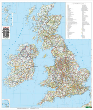
Plano Wandkaart Groot-Brittannië & Ierland - 116 x 99 cm - F&B • 5425013064590
Plano Wandkaart Groot-Brittannië & Ierland Geplastificeerd - F&B Productomschrijving: De plano politieke wandkaarten van Freytag & Berndt brengen elk continent helder in beeld. Grote, duidelijke opgerolde kaart, zonder vouwen. Ideaal om meteen op te hangen in klaslokaal, kantoor of thuis. Landen, hoofdsteden, belangrijke steden en grenzen springen in het oog. Heldere kleuren zorgen voo…

Reisgids Great Britain - Rough Guides • 9781835290415
Great Britain reisgids - Rough Guides Productomschrijving: Full-colour throughout, The Rough Guide to Britain is the ultimate guide to Rough Guides’ home patch. With 30 years experience and our trademark ‘tell it like it is’ writing style, Rough Guides cover all the basics with practical, on-the-ground details, as well as unmissable alternatives to the usual must-see sights. At the top of …
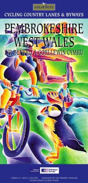
Fietskaart Pembrokeshire National Park - Goldeneye • 9781859651223
Fietskaart Pembrokeshire NP - West Wales - Goldeneye Productomschrijving: Pembrokeshire (Wels: Sir Benfro) is een bestuurlijk graafschap in het zuidwesten van Wales, gelegen in het ceremoniële behouden graafschap Dyfed. Een supergeschikte regio voor de fietser in het algemeen, rustig gelegen in de hoek van Wales. Het grenst in het oosten aan Carmarthenshire en in het noordoosten aan Ceredi…

Landkaart Wegenkaart 10 Groot Brittannië - AA Publishing • 9780749584153
Wegenkaart Groot Brittannië - AA Publishing Productomschrijving: Clearest mapping from the experts at the Automobile Association (UK), in a handy foldable map. Fully updated, the maps combine clear design and an easy-to-read scale with more road detail to ensure that you never lose your way. Each map includes information on toll points, service areas, road numbers, motorways, dual carriag…
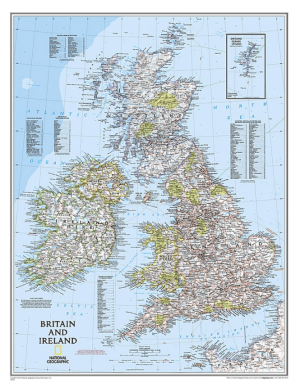
Plano Wandkaart Groot-Brittannië & Ierland 60 x 76 cm - Nat Geo • 9780792250234
Wandkaart Groot-Brittannië & Ierland 60 x 76 cm - Nat Geo Productomschrijving: National Geographic's Classic political map of Britain and Ireland is both an attractive addition to any study or classroom and an informative tool for exploring these fascinating countries. The map features thousands of place names, major highways and roads, airports, ferry routes, bodies of water, and more. Ha…