

Wandelkaart 215 Glacier & Waterton Lakes NP - Montana - Nat Geo
Glacier NP sluit nadeloos aan op het Canadese Waterten Lakes NP

Korte omschrijving
Wandelkaarten Montana, USA en Alberta, Canada van National Geographic. Ideaal voor tochten in Verenigde Staten van Amerika (USA) en Canada.
TOPO Wandelkaart 215 - Glacier & Waterton Lakes NP Productomschrijving: Glacier National Park is een nationaal park in de Amerikaanse staat Montana. Het park sluit nadeloos aan op het Canade...

Specificaties
- Uitgever: National Geographic
- ISBN-13: 9781566953184
- HOOFDCATEGORIEËN: Wandelkaart
- Activiteiten: Wandelen, Hiking & Trekking
- Auteur: National Geographic
- Regio: Alberta, Canada, Montana, USA
- Land: Canada, Verenigde Staten van Amerika (USA)
- Nationale parken: Wateron Lakes NP Alberta Canada
- TOPO's & Stafkaarten: Topografisch wandelen
- Schaal: 1:100000
- Taal: Engels
Volledige omschrijving
TOPO Wandelkaart 215 - Glacier & Waterton Lakes NP
Productomschrijving: Glacier National Park is een nationaal park in de Amerikaanse staat Montana. Het park sluit nadeloos aan op het Canadese Waterten Lakes NP net over de grens in Alberta Canada. Het park ligt in de Rocky Mountains op de grens met Canada. Zes bergtoppen bereiken er een hoogte van meer dan 3000 meter.
Engelse omschrijving: National Geographic's Trails Illustrated map of Glacier and Waterton Lakes National Parks offers unparalleled detail for outdoor enthusiasts exploring the pristine landscape of forests, mountains, lakes, and meadows within these two spectacular parks. Created in partnership with local land management agencies, this expertly researched map features key areas of interest including Many Glacier, Great Bear Wilderness, Flathead National Forest, Hungry Horse Reservoir, Lake McDonald, Flathead River, St. Mary Lake, Akamina-Kishinena Provincial Park, and the Waterton Lakes.
The Glacier and Waterton Lakes map is an invaluable resource for exploring the more than 800 miles of mapped trails within the parks, including the Pacific Northwest Trail, the Continental Divide Trail, and recommended biking trails. Recreation features are clearly marked, including campgrounds, trailheads, interpretive trails, fishing and boat access, and horse rental locations. The map base includes contour lines and elevations for summits, passes and major lakes. A variety of helpful information about recreation activities available in the parks, hiking and backcountry camping, regulations, and safety tips are included as well. Every Trails Illustrated map is printed on "Backcountry Tough" waterproof, tear-resistant paper. A full UTM grid is printed on the map to aid with GPS navigation.
Other features found on this map include: Apgar Mountains, Bowman Lake, Flathead National Forest, Flathead Range, Glacier, Great Bear Wilderness, Kintla Lake, Lake McDonald, Lake Sherburne, Lewis & Clark National Forest, Lewis Range, Livingston Range, Lower Saint Mary Lake, Mount Carter, Mount Cleveland, Mount Saint Nicholas, Mount Stimson, Saint Mary Lake, Upper Waterton Lake, Whitefish Lake.
Locatie op kaart
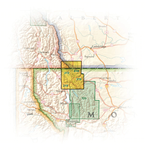
Overzichtskaarten

NAT GEO Montana trails map
NAT GEO Montana trails map

Producten op de overzichtskaart
Klik op een product om naar de detailpagina te gaan.
Artikelen uit dezelfde regio
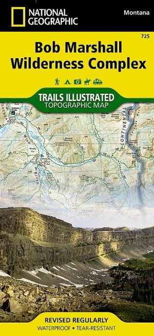
Wandelkaart 725 Bob Marshall Wilderness - Natgeo • 9781597756266
TOPO Wandelkaart 725 - Bob Marshall Wilderness - Natgeo Productomschrijving: The Bob Marshall Wilderness Area is een op kaart gemaakte wilderness area gelegen in western Montana in de United States. Dit wildernis, samen met de aanpalende bossen Scapegoat- en Great Bear wildernes, maken samen het "Bob Marshall Wilderness Complex". Engelse omschrijving: Located just north of Yellowstone…
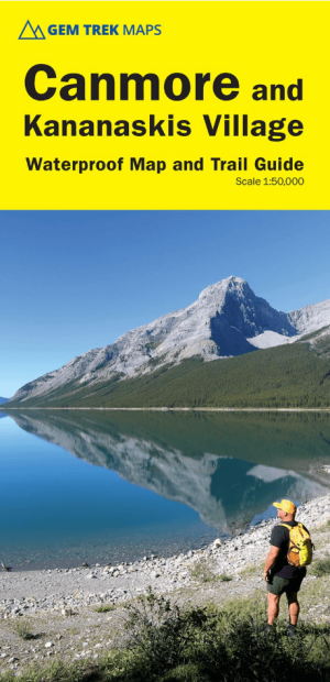
Wandelkaart Canmore & Kananaskis village Alberta - Gem Trek Publ. • 9781990161193
Wandelkaart Canmore & Kananaskis village - Gem Trek Productomschrijving: Gem Trek’s CANMORE & KANANASKIS VILLAGE MAP is designed for outdoor enthusiasts looking to explore the northern portion of Kananaskis Country. Whether you are touring along the roads or heading into the backcountry, you’ll find the waterproof and tear-resistant Canmore & Kananaskis Village Map to be an invaluable tool…
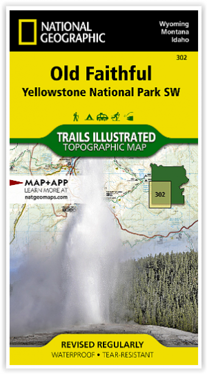

Wandelkaart 302 Yellowstone NP & Old Faithful - Nat Geo • 9781566954334
Yellowstone National Park & Old Faithful - Nat Geo Omvat: Craig Pass, Gallatin National Forest, Grand Teton National Park, Heart Lake, Jedediah Smith Wilderness, John D. Rockefeller, Jr. Memorial Parkway, Lewis Lake, Mount Sheridan, Pitchstone Plateau, Red Mountains, Shoshone Lake, Targhee National Forest, Teton National Forest, Teton Wilderness, Yellowstone National Park. Engelse omsc…
Reisgids British Columbia & the Canadian Rockies - Lonely Planet • 9781838697013
British Columbia & the Canadian Rockies - Lonely Planet Productomschrijving: Sigh-inducing mountains, mist-shrouded forests and epic tooth-and-claw wildlife: this is Canada’s legendary outdoor wonderland. And it’s served alongside a full menu of distinctive, ever-inviting communities. Lonely Planet will get you to the heart of British Columbia & the Canadian Rockies, with amazing travel ex…

Reisgids Yellowstone & Grand Teton National Parks - Lonely Planet • 9781838699819
Reisgids Yellowstone & Grand Teton - Lonely Planet Productomschrijving: Lonely Planet Yellowstone & Grand Teton National Parks is je paspoort voor het meest relevante, actuele advies over wat je moet zien en overslaan, en welke verborgen ontdekkingen er op je wachten. Spot wolven en grizzly's in Lamar Valley, zie geisers uitbarsten in Old Faithful en Upper Geyser Basin, of ga het water op …