

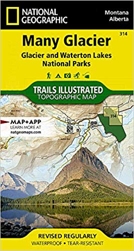
Wandelkaart 314 Many Glacier NP- Waterton lakes - Montana
Een locatie binnen het Glacier National Park
Korte omschrijving
Wandelkaarten Montana, USA van National Geographic. Ideaal voor tochten in Verenigde Staten van Amerika (USA).
TOPO Wandelkaart 314 - Many Glacier NP- Waterton lakes Productomschrijving: Many Glacier is een locatie binnen het Glacier National Park gelegen in de U.S. in de staat van Montana Engels...

Specificaties
- Uitgever: National Geographic
- ISBN-13: 9781566954709
- HOOFDCATEGORIEËN: Wandelkaart
- Activiteiten: Wandelen, Hiking & Trekking
- Auteur: National Geographic
- Regio: Montana, USA
- Land: Verenigde Staten van Amerika (USA)
- Nationale parken: Glacier NP, Montana USA, Wateron Lakes NP Alberta Canada
- TOPO's & Stafkaarten: Topografisch wandelen
- Schaal: 1:50000
- Taal: Engels
Volledige omschrijving
TOPO Wandelkaart 314 - Many Glacier NP- Waterton lakes
Productomschrijving: Many Glacier is een locatie binnen het Glacier National Park gelegen in de U.S. in de staat van Montana
Engelse omschrijving: Created in partnership with local land management agencies, National Geographic's Trails Illustrated map of Many Glacier, Glacier and Waterton Lakes National Parks offers unparalleled detail for outdoor enthusiasts exploring the pristine landscapes contained within these two spectacular parks. This expertly researched map features key areas of interest including Many Glacier, Upper Kintia Lake, Rising Sun, Saint Mary Lake, Belly River, and the Waterton Lakes.
The Many Glacier map can guide you off the beaten path and back again with hundreds of miles of mapped trails including portions of the Pacific Northwest and Continental Divide trails. The map base includes contour lines and elevations for summits, passes and many lakes. Helpful information about recreation activities available in the parks, regulations, and snow and water hazards are included as well. Recreation features are clearly marked, including campgrounds, mountain bike trails, waterfalls, picnic areas, and horse rental locations. Every Trails Illustrated map is printed on "Backcountry Tough" waterproof, tear-resistant paper. A full UTM grid is printed on the map to aid with GPS navigation.
Other features found on this map include: Glacier, Lake Sherburne, Lewis Range, Livingston Range, Lower Saint Mary Lake, Mount Cleveland, Saint Mary Lake, Upper Waterton Lake.
Locatie op kaart
Overzichtskaarten

NAT GEO Montana trails map
NAT GEO Montana trails map

Producten op de overzichtskaart
Klik op een product om naar de detailpagina te gaan.
Artikelen uit dezelfde regio

Wandelkaart 201 Yellowstone NP- Wyoming - Nat Geo • 9781566952958
TOPO Wandelkaart 201 - Yellowstone NP- Wyoming - Nat geo Productomschrijving: Yellowstone National Park, wat een prachtig concept voor een nationaal park, een par van formaat, en een nationaal park in de Verenigde Staten, hoofdzakelijk in Wyoming, maar met kleine gedeeltes in de aangrenzende staten Montana en Idaho. Engelse omschrijving: National Geographic's Trails Illustrated map of …
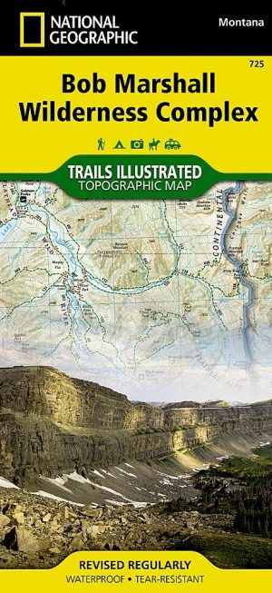
Wandelkaart 725 Bob Marshall Wilderness - Natgeo • 9781597756266
TOPO Wandelkaart 725 - Bob Marshall Wilderness - Natgeo Productomschrijving: The Bob Marshall Wilderness Area is een op kaart gemaakte wilderness area gelegen in western Montana in de United States. Dit wildernis, samen met de aanpalende bossen Scapegoat- en Great Bear wildernes, maken samen het "Bob Marshall Wilderness Complex". Engelse omschrijving: Located just north of Yellowstone…
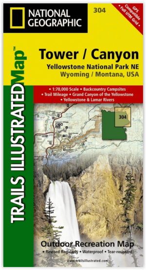
Wandelkaart 304 Tower & Canyon Yellowstone NP - Nat Geo • 9781566954358
TOPO Wandelkaart 304 - Tower & Canyon Yellowstone NP - Natgeo Productomschrijving: Deze hoeft geen uitleg, het is de thuis van de mooiste natuurlijke sites die de wereld in petto heeft, en de thuis van El Capitan, de kilometer hoge granieten steen wereldbekend door de klimmers. Kortom, een Nationaal park van formaat die iedereen kent de wereld rond. Engelse omschrijving: National Geogr…

Wandelkaart 723 Bozeman- Big Sky & Bridger Range - Natgeo • 9781566956802
TOPO Wandelkaart 723 - Bozeman- Big Sky & Bridger Range Productomschrijving: Bozeman Pass is een bergpas gelegen ongeveer 21 km ten oosten van Bozeman, Montana en ongeveer 24 km ten westen van Livingston, Montana. It verdeeld de Bridger & Gallatin bergmassieven. Engelse omschrijving: Located just north of Yellowstone National Park, Absaroka-Beartooth Wilderness is known for it high pea…

Wandelgids Rocky Mountains & Pacific Northwest NP - Lonely Planet • 9781838696085
Rocky Mountains & Pacific Northwest NP - Lonely Planet Productomschrijving: Lonely Planet's Rocky Mountains and the Pacific Northwest's National Parks is uw paspoort voor het meest actuele advies over wat je moet zien en overslaan. Beklim Grand Teton, bespioneer wilde dieren en kampeer bij Crater Lake, allemaal met je vertrouwde reisgenoot. Duik in het hart van de Rocky Mountains en de nat…