
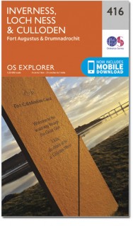
Wandelkaart 416 Inverness & Loch Ness - OSI
De lengte van Loch Ness- Inverness & de Great Glen way
Korte omschrijving
Wandelkaart Inverness- Loch Ness & Culloden - Highlands Productbeschrijving: 416 / Inverness, Loch Ness & Culloden, Highlands, Schotland - Deze twee-zijdige Explorer kaart 416 omvat de l...

Specificaties
- Uitgever: Ordnance Survey
- ISBN-13: 9780319246511
- HOOFDCATEGORIEËN: Wandelkaart
- Activiteiten: Wandelen, Hiking & Trekking
- Regio: Highlands, Schotland
- Land: Schotland
- Schaal: 1:25000
- Afmeting: 13x23
- Taal: Engels
- Reeks: Explorer Series
Volledige omschrijving
Wandelkaart Inverness- Loch Ness & Culloden - Highlands
Productbeschrijving:
416 / Inverness, Loch Ness & Culloden, Highlands, Schotland - Deze twee-zijdige Explorer kaart 416 omvat de lengte van Loch Ness en de Highland hoofdstad Inverness. De Great Glen way wandelpad op de oevers van de loch, om te zien of u het legendarisch monster kan spotten. De OS Explorer kaart voor Inverness, Loch Ness & Culloden is beschikbaar in zowel de standaard papieren versie als de weerbestendige 'Actief' versie.
416 / Inverness, Loch Ness & Culloden, Highlands, Schotland - The two-sided Explorer map 416 covers the length of Loch Ness, and the Highland capital Inverness. Walk the Great Glen way on the shores of the loch and see if you can spot the legendary monster, or set off and see if you can scale Suidhe Ghuirmain (578 m), the steep slopes of Glas-beheinn Mor (651 m) or tackle Meall Fuar-mhonaidh (699 m). The OS Explorer map for Inverness, Loch Ness & Culloden is available in both the standard paper version and weatherproof 'Active' version.
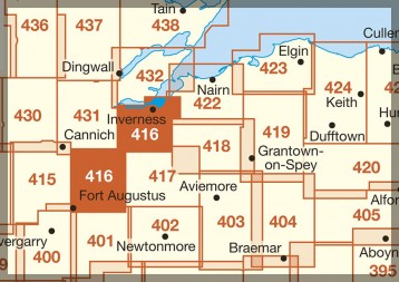
Locatie op kaart
Gekoppelde artikelen

Wandelkaart 416 Inverness & Loch Ness - OSI • 9780319246511
standaard versieWandelkaart Inverness- Loch Ness & Culloden - Highlands Productbeschrijving: 416 / Inverness, Loch Ness & Culloden, Highlands, Schotland - Deze twee-zijdige Explorer kaart 416 omvat de lengte van Loch Ness en de Highland hoofdstad Inverness. De Great Glen way wandelpad op de oevers van de loch, om te zien of u het legendarisch monster kan spotten. De OS Explorer kaart voor Inverness, L…

Wandelkaart 416 Inverness Loch Ness & Culloden - OSI • 9780319472712
weatherproof versieWandelkaart Inverness- Loch Ness & Culloden Highland's Omvat ook: Fort Augustus & Drumnadrochit. Productbeschrijving: Deze twee-zijdige Explorer kaart nummer 416 heeft betrekking op de lengte van Loch Ness en de Highland hoofdstad van Inverness. Wandel de Great Glen way op de oevers van loch Ness, om te zien of u ter plaatse het legendarische monster kunt ontdekken, of ga op verkennin…
Overzichtskaarten

OSI Explorer & Explorer Active - Ben Nevis - Glen Coe
OSI Explorer & Explorer Active - Ben Nevis - Glen Coe

Producten op de overzichtskaart
Klik op een product om naar de detailpagina te gaan.
- Wandelkaart 372 Coll & Tiree- Ayrshire & Lanark - OSI
- Wandelkaart 374 Isle of Mull North & Tobermroy - OSI
- Wandelkaart 376 Oban & North Lorn- Argyl & Bute - OSI
- Wandelkaart 377 Loch Etive & Glen Orchy- Schotland- OSI
- Wandelkaart 383 Morvern & Lochaline- Highland's - OSI
- Wandelkaart 384 Glen Coe & Glen Etive- Highlands - OSI
- Wandelkaart 385 Rannoch Moor & Ben Alder- Highland's - OSI
- Wandelkaart 390 Ardnamurchan- Highlands Schotland - OSI
- Wandelkaart 391 Ardgour & Strontian- Highlands - OSI
- Wandelkaart 392 Ben Nevis & Fort William- Highlands - OSI
- Wandelkaart 397 Rum- Eigg- Muck- Canna & Sanday - OSI
- Wandelkaart 398 Loch Morar & Mallaig- Highland's - OSI
- Wandelkaart 399 Loch Akraig- Lochaber Schotland - OSI
- Wandelkaart 400 Loch Lochy & Glen Roy- Highlands - OSI
- Wandelkaart 413 Knoydart- Loch Hourn & Loch Duich - OSI
- Wandelkaart 414 Glen Shiel & Kintail Forest- Highlands- OSI
- Wandelkaart 415 Glen Affric & Glen Moriston - OSI
- Wandelkaart 416 Inverness & Loch Ness - OSI
- Wandelkaart OL50 Ben Alder- Loch Ericht & Loch Laggan - OSI
- Wandelkaart OL55 Loch Laggan & Creag Meagaidh - OSI

OSI Explorer & Explorer Active - Noord Schotland & The Cairngorms
OSI Explorer & Explorer Active - Noord Schotland & The Cairngorms

Producten op de overzichtskaart
Klik op een product om naar de detailpagina te gaan.
- Wandelkaart 342 Glasgow Schotland - OSI
- Wandelkaart 348 Campsie Fells- Glasgow - Schotland - OSI
- Wandelkaart 349 Falkirk- Cumbernauld & Livingston - OSI
- Wandelkaart 350 Edinburgh - East Schotland - OSI
- Wandelkaart 351 Dunbar & North Berwick - Edinburgh - OSI
- Wandelkaart 366 Stirling & Ochil Hills West - OSI
- Wandelkaart 367 Dunfermline- Kirkcaldy & Glenrothes - OSI
- Wandelkaart 369 Perth & Kinross - Schotland - OSI
- Wandelkaart 370 Glenrothes North- Falkland & Lomond Hills - OSI
- Wandelkaart 371 St-Andrews & East Fife- Schotland - OSI
- Wandelkaart 379 Dunkeld & Aberfeldy- Glen Almond - OSI
- Wandelkaart 380 Dundee & Sidlaw Hills- Fife - OSI
- Wandelkaart 381 Blairgowrie & Kirriemuir - OSI
- Wandelkaart 382 Arbroath- Montrose & Carnoustie - OSI
- Wandelkaart 385 Rannoch Moor & Ben Alder- Highland's - OSI
- Wandelkaart 389 Forfar- Brechin & Edzell- Tayside - OSI
- Wandelkaart 396 Stoneheaven- Inverbervie & Laurencekirk - OSI
- Wandelkaart 406 Aberdeen & Banchory- Schotland - OSI
- Wandelkaart 416 Inverness & Loch Ness - OSI
- Wandelkaart 417 Monadhliath Mountains North - OSI
- Wandelkaart 421 -llon & Inverurie- Aberdeenshire - OSI
- Wandelkaart 422 Nairn & Cawdor- Inverness - OSI
- Wandelkaart 423 Elgin- Forres & Lossiemouth - OSI
- Wandelkaart 424 Buckie & Keith- Granpian - OSI
- Wandelkaart 425 Huntly & Cullen- Aberdeenshire - OSI
- Wandelkaart 426 Banff- Macduff & Turriff- Aberdeenshire - OSI
- Wandelkaart 427 Peterhead & Fraserburgh- Aberdeenshire - OSI
- Wandelkaart 431Glen Urquhart & Strathglass - OSI
- Wandelkaart 432 Black Isle & Munlochy - OSI
- Wandelkaart OL46 Trossachs- Callander & Aberfoyle - OSI
- Wandelkaart OL49 Pitlochry & Loch Tummel- perth & Kinross - OSI
- Wandelkaart OL50 Ben Alder- Loch Ericht & Loch Laggan - OSI
- Wandelkaart OL51 Atholl- Glen Tilt & Beinn Dearg - OSI
- Wandelkaart OL52 Glen Shee- Braemar & Cairnwell - OSI
- Wandelkaart OL53 Lochnagar- Glen Muick & Glen Clova - OSI
- Wandelkaart OL54 Glen Esk- Glen Tanar & Aboyne - OSI
- Wandelkaart OL55 Loch Laggan & Creag Meagaidh - OSI
- Wandelkaart OL56 Loch Laggan & Creag Meagaidh - OSI
- Wandelkaart OL57 Cairn Gorm- Aviemore & Loch Morlich - OSI
- Wandelkaart OL58 Braemar- Tomintoul & Glen Avon - OSI
Artikelen uit dezelfde regio

Wandelkaart 57 Stirling & The Trossachs NP Schotland - OSI • 9780319261552
Wandelkaart Stirling & The Trossachs NP - Schotland Productbeschrijving: OS Landranger kaart 57 van Stirling & The Trossachs, omvat ook Ben Vorlich, Mor Bheinn, Ling Hill, Ben Ledi, Venachar Loch, Loch Katrine, Loch Ard evenals deel van de Loch Lomond en de Trossachs nationaal park. Stirling en het kasteel is zeker een bezoekje waard, terwijl het nabijgelegen Wallace Monument in een indruk…

Wandelkaart 441 Lairg Bonar Bridge & Golspie - OSI • 9780319472934
Wandelkaart Lairg- Bonar Bridge & Golspie - Highland's Schotland Omvat ook: Dornoch & Brora. Productbeschrijving: Aan de Moray Firth toont OS Explorer kaart 441 de regio Brora naar Dornoch en het binnenland van Lairg bij Bonar Bridge. Verken rond Loch Fleet en Loch Brora of volg de rivier van Loch Shin naar Kyle of Sutherland. De OS Explorer kaart voor Lairg, Bonar Bridge & Golspie is …


Wandelkaart 415 Glen Affric & Glen Moriston Schotland - OSI • 9780319472705
Wandelkaart Glen Affric & Glen Moriston - Iverness Highland's Omvat ook: Cannich. Productbeschrijving: Kaart nummer 415 in de OS Explorer kaarten reeks is ideaal voor het ontdekken van het gebied rond Glen Affric in de hooglanden van Schotland. Glen Affric is een National Scenic Area, en biedt de mogelijkheid voor vele wandelingen rond prachtige landschappen. Er zijn vele Lochs om te o…

Reisgids Scottish Highlands & Islands - Rough guides • 9780241272312
Scottish Highlands & Islands - Rough guides Product description: This fully updated The Rough Guide to Scottish Highlands and Islands is the ultimate guidebook to the captivating remote reaches of Scotland. From the divine seafood offerings at Loch Fyne to the whisky distilleries on Islay, this is a place for indulging. It’s also a hotspot for outdoor activities, whether you decide to bag …

Wandelkaart 398 Loch Morar & Mallaig Schotland - OSI • 9780319472583
Wandelkaart Loch Morar & Mallaig - Highlands Schotland Productbeschrijving: Het gebied rondom Loch Morar en het haven dorp Mallaig zijn wild, mooi en exteem. De A830 linkt Mallaig Glenfinnan met Fort William, maar afgezien daarvan zult u op ongemarkeerde land en ongemarkeerd paden wandelen - een goede kaart en navigatie vaardigheden zijn een must. Loch Morrar is het diepste zoetwater l…