

Wandelkaart 760 Kenai National Wildlife Refuge - Alaska - Nat Geo
Omvat eveneens het Chugach National Forest

Korte omschrijving
Wandelkaarten Alaska, USA van National Geographic. Ideaal voor tochten in Verenigde Staten van Amerika (USA).
TOPO Wandelkaart 760 - Kenai National Wildlife Refuge - Alaska Productomschrijving: The Kenai National Wildlife Refuge is a 1.92-million-acre (7,770 km2) wildlife habitat preserve located on...

Specificaties
- Uitgever: National Geographic
- ISBN-13: 9781566953733
- HOOFDCATEGORIEËN: Wandelkaart
- Auteur: National Geographic
- Regio: Alaska, USA
- Land: Verenigde Staten van Amerika (USA)
- Regionale parken: Chugach National Forest, Alaska USA, Kenai National Wildlife Refuge, Alaska USA
- TOPO's & Stafkaarten: Topografisch wandelen
- Schaal: 1:105600
- Taal: Engels
Volledige omschrijving
TOPO Wandelkaart 760 - Kenai National Wildlife Refuge - Alaska
Productomschrijving: The Kenai National Wildlife Refuge is a 1.92-million-acre (7,770 km2) wildlife habitat preserve located on the Kenai Peninsula of Alaska, United States. It is adjacent to Kenai Fjords National Park.
Engelse omschrijving: National Geographic's Trails Illustrated map of Kenai National Wildlife Refuge was created for all outdoor enthusiasts adventuring in this diverse area on the Kenai Peninsula in Alaska. Created in cooperation with U.S. Fish and Wildlife, U.S. Forest Service, National Park Service and others, this expertly researched map contains an abundance of information about the recreational opportunities available in the area. Coverage includes Kenai NWR, Wilderness and Mountains; Chugach Nation Forest, Tustumena, Kenai and Swan Lakes; Skilak Lake and Wildlife Recreation Area; Seward and Sterling Highways; Kenai, Swanson and Resurrection Rivers; Turnagain Arm; Iditarod National Historical Trail; and a number of State Recreation Areas and Sites.
Let the map guide you over land and water with mapped hiking, equestrian, Nordic ski and ATV trails, bike paths, canoe routes and a complete road network, including numbered Forest Service roads and scenic byways. Trails are labeled according to designated usage and are shown with mileage markers as is the Swanson River canoe route. Your navigation will be aided by the map's contour lines, elevations, labeled passes, peaks and summits, water features and glaciers, as well as boating hazard areas, soundings and nautical beacons. Among the recreation and adventure features pinpointed are campgrounds, trailheads, interpretive trails, anchorage points, boat ramps, dog mushing areas, wildlife viewing areas and scenic viewpoints. Background information and regulations of the area is also provided as well as QR codes for fishing and hunting licensing and current weather conditions. Every Trails Illustrated map is printed on "Backcountry Tough" waterproof, tear-resistant paper. A full UTM grid is printed on the map to aid with GPS navigation.
Other features found on this map include: Chugach National Forest, Kenai Lake, Skilak Lake, Turnagain Arm, Tustumena Lake.
Locatie op kaart
Overzichtskaarten

NAT GEO Alaska trails map
NAT GEO Alaska trails map
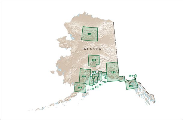
Producten op de overzichtskaart
Klik op een product om naar de detailpagina te gaan.
- Wandelkaart 248 Katmai NP- Alaska - Nat Geo
- Wandelkaart 254 Chilkoot Trail - Klondike Gold Rush - Nat Geo
- Wandelkaart 255 Glacier Bay NP- Alaska - Nat Geo
- Wandelkaart 257 Gates of the Arctic NP- Alaska - Nat Geo
- Wandelkaart 760 Kenai National Wildlife Refuge - Alaska - Nat Geo
- Wandelkaart 761 Prince William Sound West - Alaska - Nat Geo
- Wandelkaart 763 Kachemak Bay State Park - Alaska - Nat Geo
Artikelen uit dezelfde regio

Wandelkaart 257 Gates of the Arctic NP- Alaska - Nat Geo • 9781566953764
TOPO Wandelkaart 257 - Gates of the Arctic NP - Alaska Productomschrijving: Het Gates of the Arctic National Park and Preserve is een nationaal park ten noorden van de noordpoolcirkel in de Amerikaanse staat Alaska. Het is het meest noordelijk gelegen en op een na grootste nationale park van de Verenigde Staten. Met een oppervlakte van 34.287 km² is het park iets kleiner dan Zwitserland. …
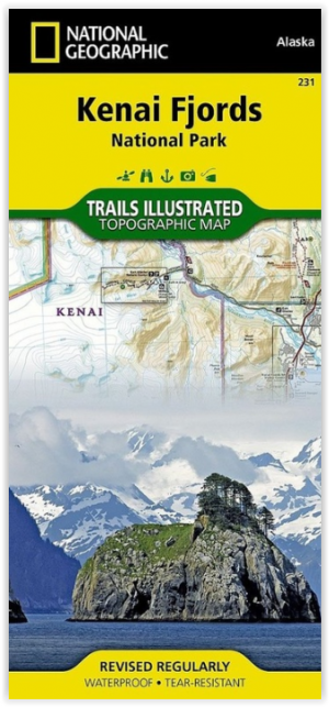
Wandelkaart 231 Kenai Fjords NP- Alaska - Nat Geo • 9781566953856
TOPO Wandelkaart 231 - Kenai Fjords NP- Alaska - Nat Geo Productomschrijving: Kenai Fjords National Park is een nationaal park in de Amerikaanse staat Alaska, gelegen op het Kenai-schiereiland. Grote delen van de Kenai Mountains worden beschermd in het park. In het park ligt het Harding Icefield, een van de grootste ijsvelden van de Verenigde Staten. Engelse omschrijving: National Geog…

Klimgids Denali - Mt McKinley - Rucksack reades • 9781898481539
Klimgids Denali - Mt McKinley - Summit of North America Productomschrijving: Met zijn 6194 m (20,320 ft) is Denali (Mt McKinley) de hoogste berg in Noord-Amerika. De Arctische latitude zorgt voor extreme weersomstandigheden en de afgelegen wildernis van Alaska betekent dat klimteams zelfstandig en ervaren moeten zijn. De auteur richte zich op de westelijke Buttress route die wordt gebruikt…

Wandelkaart 248 Katmai NP- Alaska - Nat Geo • 9781566952903
TOPO Wandelkaart 248 - Katmai NP- Alaska - Nat Geo Productomschrijving: Katmai National Park is een Amerikaans nationaal park in het zuiden van de staat Alaska, gelegen op het Alaska-schiereiland. Het ligt ongeveer 450 kilometer ten zuidwesten van de stad Anchorage. Het gebied is alleen per boot of vliegtuig te bereiken. Engelse omschrijving: Known for its large population of bears an…

Wandelkaart 763 Kachemak Bay State Park - Alaska - Nat Geo • 9781566950749
Wandelkaart Kachemak Bay State Park, Homer Alaska Omvat: Anchor Point, Chugach Islands, Fox River, Gore Point, Kachemak Bay, Kalgin Island, Kenai Fjords National Park, Kennedy Entrance, Nuka Bay, Nuka Island, Point Adam, Point Pogibshi, Port Dick, Tustumena Lake. Engelse omschrijving: Outdoor enthusiasts exploring the various public recreation lands in the southwestern part of the Kena…
