

Fietsgids Pennine Bridleway Cycling guide - Vertebrate Publ.
From Derbyshire through the Yorkshire Dales to Cumbria

Korte omschrijving
Fietsgidsen Cumbria & Lake District, England, Derbyshire & Peak District, England, North England en Midlands, England van Vertebrate Publishing. Ideaal voor tochten in United Kingdom, Great Britain.
Pennine Bridleway Cycling guide - Vertebrate Productomschrijving: From Derbyshire through the Yorkshire Dales to Cumbria Pennine Bridleway by Hannah Collingridge is a guidebook to this N...

Specificaties
- Uitgever: Vertebrate Publishing
- ISBN-13: 9781839810428
- HOOFDCATEGORIEËN: Fietsgids
- Auteur: Hannah Collingridge
- Regio: Cumbria & Lake District, England, Derbyshire & Peak District, England, Midlands, England, North England
- Land: United Kingdom, Great Britain
- AONB - Area of Outstanding Beauty/National Landscape: Northern Pennines AONB
- Taal: Engels
- Fietsen: Fietsen in het Buitenland
- National Trails UK, England & Wales: Pennine Way, England
- VTT / MTB: Mountainbike
Volledige omschrijving
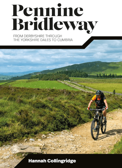
Pennine Bridleway Cycling guide - Vertebrate
Productomschrijving: From Derbyshire through the Yorkshire Dales to Cumbria
Pennine Bridleway by Hannah Collingridge is a guidebook to this National Trail taking you from Derbyshire through the Yorkshire Dales to Cumbria, following the Pennine Hills AONB. Together with stunning photography, the route features Ordnance Survey 1:50,000 maps, easy-to-follow directions and interesting facts about landmarks along the way.
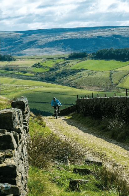
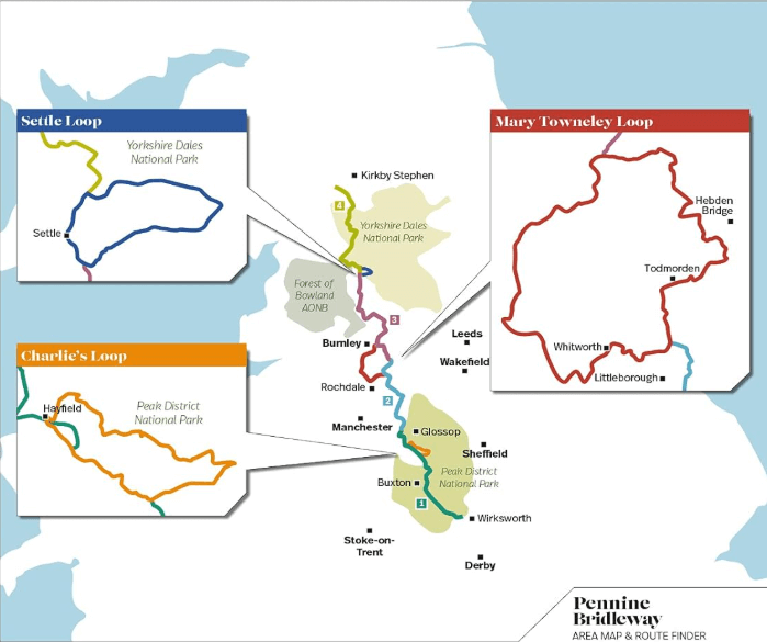
Pennine Bridlewayis a guidebook to this National Trail taking you on a multi-day off-road cycling adventure from Derbyshire through the Yorkshire Dales to Cumbria, following the Pennine Hills. This big ride is split into four sections; each section includes detailed directions as well as information on points of interest along the route, bringing the history and landscape of the trail into context.
There are also three loops, including the Mary Towneley Loop, which can be tackled separately or as part of the main trail. The guidebook is illustrated throughout with stunning action photography by professional photographer Joolze Dymond. Researched, ridden and written by mountain biking expert and freelance writer Hannah Collingridge, this guidebook features clear and easy to use Ordnance Survey 1:50,000 maps, easy-to-follow directions, details of distance, ascent and difficulty gradings, bikepacking hints and tips and local knowledge.
Artikelen uit dezelfde regio

Wandelkaart OL19 - Howgill Fells and Upper Eden Valley - OSI • 9780319475362
Wandelkaart Howgill Fells and Upper Eden Valley - OSI Productomschrijving: Kaart nummer OL19 in de OS Explorer serie omvat: Appleby-in-Westmorland, de Howgill Fells, Sedbergh, Upper Eden Valley en Kirkby Stephen. Hoogtepunten van het gebied zijn onder andere: Yorkshire Dales National park, North Pennines, Pennine Way, rivier Eden, Great Shunner Fell en Hardraw. National trails and …
Wandelgids Rocky Rambler's wild walks - Cicerone • 9781852843472
Wandelgids - Rocky Rambler's wild walks - Cicerone Productomschrijving: Een gids over familiewandelen in het Lake District. Rocky Rambler's Wild Walks stimuleert kinderen om uit te kiezen, en de wandelingen te leiden. Gericht op kinderen van 6 tot 14 jaar, de gids bevat duidelijke instructies en heldere illustraties, die iedere wandeling gemakkelijk en leuk maakt om te volgen. 10 wandeling…

Wandelgids Coast to Coast path - Trailblazer • 9781912716258
Coast to Coast path 370 km - Trailblazer Productomschrijving: 109 kaarten, 14 etappe kaarten en 60 kleurfoto's van één van Engeland's mooiste wandelroutes, en tevens meest gekend. Het Coast to Coast Pad is een pad van 307 km dat loopt van St Bees aan de Ierse Zee over de breedte van Noord-Engeland naar de Noordzee bij Robin Hood's Bay. Deze spectaculaire wandeling van twee weken doorkruist…

Wandelgids Peak District Boundary Walk - Vertebrate Publ. • 9781909461536
Peak District Boundary Walk - Vertebrate Productomschrijving: 190 miles around the edge of the National Park To celebrate Britain's first national park, supporters of Friends of the Peak District have devised a 190-mile walking route around its boundary – the Peak District Boundary Walk. Peak District Boundary Walk includes a detailed route description, Ordnance Survey 1:25,000-scale …

Reisgids Lake District NP Cumbria England - Marco Polo • 9783829758406
Reisgids Lake District - Marco Polo Productomschrijving: Marco Polo reisgids voor het Lake District! Handig pocket formaat, boordevol informatie, met 8 bladzijden atlas in de gids én uitneembare kaart. Met 'insider tips' om deze waterrijke Britse regio écht te ontdekken, de TOP 15 van bezienswaardigheden in één oogopslag, up-to-date informatie in overzichtelijke hoofdstukken: sightseeing, …