

Fietsgids Yorkshire Dales Mountain Biking - Vertebrate Publ.
26 rides in one of the UK’s most MTB-friendly national parks


Korte omschrijving
Fietsgidsen Yorkshire Dales en Yorkshire, England van Vertebrate Publishing. Ideaal voor tochten in England.
Yorkshire Dales Mountain Biking - Vertebrate Productomschrijving: Classic Pennine Trails Yorkshire Dales Mountain Biking by Nick Cotton features 26 rides in one of the UK’s most MTB-fri...

Specificaties
- Uitgever: Vertebrate Publishing
- ISBN-13: 9781912560066
- HOOFDCATEGORIEËN: Fietsgids
- Auteur: Nick Cotton
- Regio: Yorkshire Dales, Yorkshire, England
- Land: England
- Nationale parken: Yorkshire Dales NP, England
- Taal: Engels
- De Engelse Graafschappen: Yorkshire
- VTT / MTB: Mountainbike
Volledige omschrijving
Yorkshire Dales Mountain Biking - Vertebrate
Productomschrijving: Classic Pennine Trails
Yorkshire Dales Mountain Biking by Nick Cotton features 26 rides in one of the UK’s most MTB-friendly national parks. Includes rides around Swaledale, Ingleborough, Whernside and Pen-y-ghent. Each ride is described with easy-to-follow directions and is plotted on clear and easy to use Ordnance Survey 1:50,000 mapping.
Yorkshire Dales Mountain Biking features 26 rides between 10 and 43 kilometres in length in one of the UK’s most MTB-friendly national parks. The routes make the most of the Dales’ superb network of stone-based trails, rideable in all seasons. Classic loops take in the best of Swaledale, a tour of Ingleborough, big days around Whernside and Pen-y-ghent, quintessential Dales scenery near Malham and Kilnsey, and moorland riding above Pateley Bridge.
A Bonus Section includes information about the Howgills, the easy-going Swale Trail and the Pennine Bridleway, as well as the riding at Gisburn Forest and Stainburn which lies just outside the national park. There are also top tens and a detailed appendix. Written by Dales local and experienced author Nick Cotton, each ride is described with easy-to-follow directions and is plotted on clear and easy-to-use Ordnance Survey 1:50,000 mapping. Also included with each ride are details of distance, timings and difficulty gradings, plus refreshment stops and local knowledge.
Artikelen uit dezelfde regio
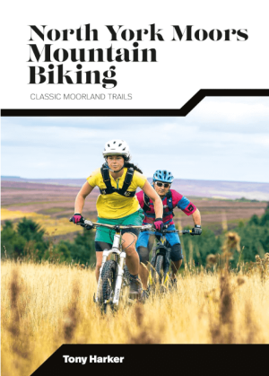
Mountainbikegids North York Moors Mountain Biking - Vertebrate • 9781839811920
North York Moors Mountain Biking - Vertebrate Productomschrijving: North York Moors Mountain Biking – Moorland Trails is the fully updated second edition of the bestselling guide to some of the finest mountain biking in the North of England. Featured are over 20 of the best mountain bike rides in the North York Moors, between 10 and 76 Km in length, suitable for all levels of mountain bik…

Wandelgids 50 walks in West Yorkshire - AA Publi. • 9780749583798
50 walks in West Yorkshire - AA Publishing Productomschrijving: West Yorkshire, een regio die de perfecte balans biedt tussen natuur en stedelijke charme, heeft veel te bieden voor wandelaars. De gids "50 Walks in West Yorkshire" neemt je mee langs schilderachtige routes door glooiende landschappen, historische locaties en levendige steden. Wat Kun Je Verwachten? Prachtige Natuur: …

Wandelgids Day Walks in the North York Moors - Vertebrate Publ. • 9781906148324
Day Walks in the North York Moors - Vertebrate Productomschrijving: 20 circular routes in North Yorkshire Day Walks on the North York Moors showcases 20 circular walks, between 5 and 13.7 miles (8 and 22 kilometres) in length, suitable for hillwalkers of all abilities. The routes are split into three areas – The Cleveland Hills and Hambleton Hills, Central Moors and Coastal Walks – an…
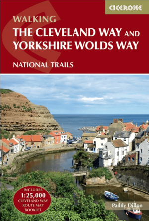
Wandelgids The Cleveland Way & Yorkshire Wolds Way - CIcerone • 9781786312211
Wandelgids The Cleveland Way & Yorkshire Wolds Way - CIcerone Productomschrijving: De vernieuwede wandelgids over de Cleveland Way en Yorkshire Wolds Way National Trails, plus de Tabular Hills Walk. De drie routes lopen door het North York Moors National Park, langs de kust en op het rustige platteland en kunnen worden samengevoegd tot een gemakkelijke rondwandeling van meer dan 400 km. In…

Wandelkaart XT40 Yorkshire Wolds Way Yorkshire - Harvey Maps • 9781851375929
Wandelkaart XT40 - Yorkshire Wolds Way Yorkshire - Harvey Maps Productomschrijving: De Yorkshire Wolds Way, (127km) is een National Trail in Yorkshire, Engeland. De route loopt van Hessle naar Filey, rond de Yorkshire Wolds. Bij Filey Brigg verbindt hij met de Cleveland Way, een ander National Trail. In 2007 vierde de Yorkshire Wolds Way de 25ste verjaardag van de officiële opening die pla…