

Landkaart Wegenkaart 3 Schotland Zuid & Northumberland - OSI
Southern Scotland- Northumberland in the North of England


Korte omschrijving
Wegenkaart Schotland Zuid & Northumberland - OSI Productomschrijving: Plan your journey with this series of road maps from OS. Showing all major road, rail and ferry links as well as settle...

Specificaties
- Uitgever: Ordnance Survey
- ISBN-13: 9780319263754
- HOOFDCATEGORIEËN: Wegenkaart - Landkaart
- Activiteiten: Street/Road maps & city plans
- Regio: Northumberland, Engeland, Zuid Schotland
- Land: England, Schotland
- Schaal: 1:250000
- Taal: Engels
- Reeks/Serie: OSI Regional UK Roadmaps 1:250.000
- De Engelse Graafschappen: Northumberland
- De Nationale Parken: Northumberland National Park, England
Volledige omschrijving
Wegenkaart Schotland Zuid & Northumberland - OSI
Productomschrijving: Plan your journey with this series of road maps from OS. Showing all major road, rail and ferry links as well as settlements and selected features in 1: 250 000 scale, this is the ideal map for planning trips and holidays by car or cycle.
OS Road 3 covers: Southern Scotland plus Northumberland in the North of England.

Overzichtskaarten
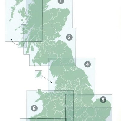
OSI Roadmaps UK 1 > 8 - 1:250.000
OSI Roadmaps UK 1 > 8 - 1:250.000

Producten op de overzichtskaart
Klik op een product om naar de detailpagina te gaan.
- Landkaart Wegenkaart 1 Schotland Noord - OSI
- Landkaart Wegenkaart 2 Schotland West & Western Isles - OSI
- Landkaart Wegenkaart 3 Schotland Zuid & Northumberland - OSI
- Landkaart Wegenkaart 4 Engeland Noord - OSI
- Landkaart Wegenkaart 5 Midlands Oost & East Anglia - OSI
- Landkaart Wegenkaart 6 Wales & Midlands West - OSI
- Landkaart Wegenkaart 7 Zuidwest Engeland & Zuid Wales - OSI
- Landkaart Wegenkaart 8 Zuidoost Engeland - OSI
Artikelen uit dezelfde regio

Reisgids Go Slow Northumberland - Bradt travel guides • 9781804692530
Reisgids Northumberland England - Bradt Productomschrijving: The best-selling title in Bradt's award-winning series of Slow Travel guides to UK regions, the new third edition of this wide-ranging guidebook to Northumberland has been thoroughly updated by travel writer Gemma Hall, who grew up locally. With more castles than any other country, Britain's most ROman important monument (Hadrian…

Wandelkaart St Cuthbert's Way XT40 - Harvey Maps • 9781851377237
Wandelkaart St Cuthbert's Way - Harvey Maps Productomschrijving: De gehele route op één kaart, Eén van de bekendste routes van Schotland. De St Cuthbert's Way verbindt plaatsen die verband houden met het leven van de Heilige uit de 7e eeuw, Cuthbert. Van Melrose Abbey naar Holy Island (Lindisfarne). 100 km (62 mijl). - De kaart is sterk, licht, duurzaam en 100% waterbestendig - …

Wandelgids Lowther Hills Schotland - Cicerone • 9781852842758
Wandelgids - Lowther Hills Schotland - Cicerone Productomschrijving: Een gids over wandelen in het zuiden van Schotland's Lowther Hills. Heeft betrekking op de Lowther Hills, Nithsdale, Carsphairn Heuvels en de bergen en heuvels van de Solway coast, Cairnsmore of Fleet, Tinto en Cauldcleuch Head. Prachtige landschappen, toegankelijk maar rustig, dit gebied biedt een aantal van de beste hil…

Wandelgids Park Rangers Favourite Walks Northumberland - Collins • 9780008462710
Park Rangers Favourite Walks Northumberland - Collins Productomschrijving: Wandelgids voor het Northumberland National Park, met 20 van de beste routes uitgekozen door de parkwachters. Elke wandeling varieert in lengte van 2 tot 10 km en kan in minder dan 4 uur worden afgelegd. Engelse omschrijving: Walking guide to the Northumberland National Park, with 20 best routes chosen by the pa…
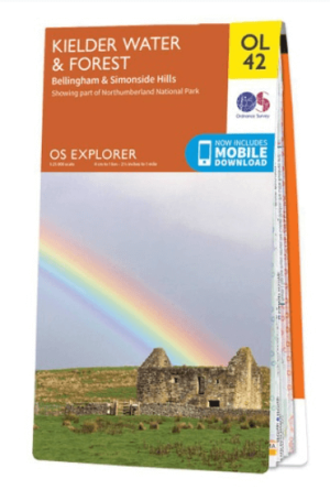
Wandelkaart OL42 Kielder Water & Forest - OS • 9780319242810
Wandelkaart Kielder Water & Forest - OS Productomschrijving: Kielder Water & Forest, Bellingham & Simonside Hills, part of Northumberland National Park, Pennine Way, St Oswald's Way, Lakeside Way & E2 European long distance Path. Omvat: Kielder Water & Forest, Bellingham & Simonside Hills Ontdek de OL-serie van Ordnance Survey: De OL-serie (Outdoor Leisure) van Ordnance Survey i…