

Wandelgids Cotswolds - Heart of the Cotswolds - Rucksack Readers
Cotswolds Area of Outstanding Natural Beauty - AONB

Korte omschrijving
Wandelgidsen Somerset South West England, Warwickshire, West Midlands, Wiltshire, West England, Oxfordshire west England en Worcestershire, West England van RUCKSACK READERS. Ideaal voor tochten in England.
Wandelgids Cotswolds - Heart of the Cotswolds - Rucksack Productomschrijving: The Cotswolds AONB is quintessentially English, with its rich cultural history, medieval ‘wool’ churches and ch...

Specificaties
- Uitgever: RUCKSACK READERS
- ISBN-13: 9781913817268
- HOOFDCATEGORIEËN: Wandelgids
- Activiteiten: Wandelen, Hiking & Trekking
- Regio: Oxfordshire west England, Somerset South West England, Warwickshire, West Midlands, Wiltshire, West England, Worcestershire, West England
- Land: England
- AONB - Area of Outstanding Beauty/National Landscape: Cotswolds AONB
- Schaal: 1:50000
- Editie: 2
- Taal: Engels
- De Engelse Graafschappen: Oxfordshire, Somerset, Warwickshire, Wiltshire, Worcestershire
Volledige omschrijving
Wandelgids Cotswolds - Heart of the Cotswolds - Rucksack
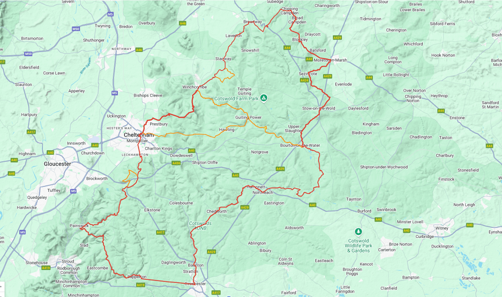
Productomschrijving: The Cotswolds AONB is quintessentially English, with its rich cultural history, medieval ‘wool’ churches and charming domestic architecture of stone, slate and thatch. The book offers three options for walking in the heart of this wonderful area: a 94-mile (151-km) grand tour starting from Cheltenham, and two shorter circuits. These options cater for walkers who want to spend eight, six or four days. There are good rail links from London, Oxford and Birmingham and lots of welcoming pubs and B&Bs.
Falls under de association of the Area's of Outstanding Natural Beauty - AONB
This guidebook contains all you need to plan and enjoy your trip:
• detailed route description, plus summaries with distance, terrain and food/drink stops
• large-scale mapping (1:50,000) on 20 pages
• planning information for transport and accommodation
• detail about Cotswold stone, sheep and wildlife
• the culture of the Cotswold region
• lavishly illustrated, with 110 colour photographs
• rucksack-friendly format, printed on rainproof paper.
Artikelen uit dezelfde regio

Reisgids Bath- Bristol & Somerset - Rough Guides • 9781839059841
Bath- Bristol & Somerset - Rough Guides Productomschrijving: De regio van somerset in Zuid west Engeland, biedt u in deze gids de uitlopers van Exmoor nationaal park, Bath, Bristol en de volledige regio Somerset. Engelse omschrijving: From the genteel Georgian terraces of Bath to the wilderness expanses of Exmoor NP, the fully updated The Rough Guide to Bath, Bristol & Somerset provide…
Wandelkaart OL09 Exmoor NP Devon England - OS • 9780319242483
Wandelkaart Exmoor NP Devon England - OS Productomschrijving: Exmoor National Park, Devon England Omvat: Exmoor National Park, Devon England, Barnstaple, Lynton, Minehead & Dulverton. Ontdek de OL-serie van Ordnance Survey: De OL-serie (Outdoor Leisure) van Ordnance Survey is dé referentie voor wie gaat wandelen op de Britse eilanden. Deze topografische kaarten maken deel uit va…

Cotswolds Mountain Biking - Vertebrate Publ. • 9781906148140
Cotswolds AONB Mountain Biking - Vertebrate Productomschrijving: 20 Classic Rides - Cotwolds Mountain Biking by Tom Fenton features 20 classic MTB routes in the Cotswold Hills across the counties of Gloucestershire and Oxfordshire, and extending into parts of Wiltshire, Somerset, Worcestershire and Warwickshire. With Ordnance Survey mapping and easy-to-follow directions. The Cotswold H…

Wandelgids 084 Pathfinder Berkshire- Buckinghamshire- Oxfordshire • 9780319092279
Wandelgids Berkshire- Buckinghamshire- Oxfordshire Productomschrijving: This all-new Pathfinder® Guide covering the ceremonial counties of Berkshire, Buckinghamshire and Oxfordshire features 28 outstanding circular walks across all three counties, offering more wonderful Pathfinder® routes in the south-central Midlands between the Cotswolds (PF 6 Cotswolds) and the Chilterns (PF 25 Thames…

Wandelkaart 129 Yeovil & Sherborne - Somerset - OSI • 9780319243251
Wandelkaart Yeovil & Sherborne - Dorset and Somerset - OSI Omvat ook: Somerton & Wincanton. Productbeschrijving: Kaart nummer 129 in de OS Explorer kaarten reeks beslaat een gebied van Somerton en Wincanton in het noorden van Yeovil en Sherborne rond North Dorset en Somerset. Hoogtepunten van het gebied van de Monach Way, Stour Valley Way en Macmillan Way West. De OS Explorer kaart voo…