
Wandelgids The Great Glen Way - Trailblazer
The Great Glen Way begint waar de West Highland Way eindigt
Korte omschrijving
The Great Glen Way - Trailblazer Publications Productomschrijving: The Great Glen Wayfrom Fort William to Inverness. Het langeafstandswandelpad Great Glen Way begint waar de West Highland Wa...

Specificaties
- Uitgever: Trailblazer Publications
- ISBN-13: 9781912716104
- HOOFDCATEGORIEËN: Wandelgids
- Activiteiten: Wandelen, Hiking & Trekking
- Regio: Highlands, Schotland
- Land: Schotland
- Historische wandelroutes: The Great Glen Way (119 km)
- Blz.: 192
- Afmeting: 12x18
- Editie: 2
- Taal: Engels
Volledige omschrijving
The Great Glen Way - Trailblazer Publications
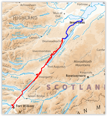
Productomschrijving: The Great Glen Wayfrom Fort William to Inverness. Het langeafstandswandelpad Great Glen Way begint waar de West Highland Way eindigt - in Fort William - en volgt de breuklijn van de Great Glen om na 79 mijl (127 km) te eindigen in Inverness. Het pad loopt langs Loch Lochy, Loch Oich en Loch Ness en volgt ook het jaagpad van het Caledonisch Kanaal. Het is een relatief gemakkelijke wandeling van een week in een prachtig Highland landschap, maar er is een hooggelegen optie tussen Fort Augustus en Drumnadrochit die een nog beter uitzicht op de bergen biedt.
192 pages,
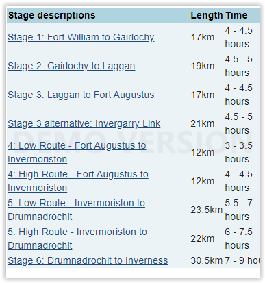
38 trail maps + 10 town plans
40 colour photos + 4pp colour flower guide
8 stage maps + 2 overview maps
Engelse omschrijving: The Great Glen Way long-distance footpath begins where the West Highland Way ends – at Fort William – and follows the Great Glen faultline to finish at Inverness after 79 miles (127km). The trail passes Loch Lochy, Loch Oich and Loch Ness and also follows the towpath of the Caledonian Canal. It’s a relatively easy week-long walk amongst beautiful Highland scenery but there’s a high level option between Fort Augustus and Drumnadrochit that gives even better mountain views.
Features:
1. Unique mapping features – In many walking guides the reader has to read a route description then try to relate it to the map. Our guides are easier to use because walking directions, tricky junctions, places to stay and eat, points of interest and walking times are all written onto the maps themselves in the places to which they apply. With their uncluttered clarity, these are not general-purpose maps but fullyedited maps drawn by walkers for walkers. Downloadable GPS waypoints also included.
2. The largest scale walking maps available – At just under 1:20,000 (8cm or 31/8 inches to 1 mile) our maps are bigger than even the most detailed walking maps currently available in the shops.
3. An all-in-one guide – Trailblazer guides include practical information not usually found in walking guides to the UK: reviews of places to stay, places to eat, attractions along the way and detailed public transport information showing all access points on the path, for weekend and day walkers.
Locatie op kaart
Overzichtskaarten

Hystorische wandel- en fietsroutes
Hystorische wandel- en fietsroutes

Producten op de overzichtskaart
Klik op een product om naar de detailpagina te gaan.
- Wandelkaart - South Downs Way - Harvey maps
- Wandelgids - North Yorkshire historic walks - Cicerone
- Wandelkaart OL13 - Brecon Beacons NP - Eastern area - OSI
- Wandelgids - Pilgrim Pathways walking guide - Trailblazer
- Wandelgids - The Great Glen Way - Trailblazer
- Wandelgids - Hadrian's wall Path - Knife Edge
- Wandelgids - Hadrian's Wall Path - Trailblazer
- Wandelkaart XT40 - Offa's Dyke Path - Harvey Maps
- Wandelkaart OL43 - Hadrian's Wall - OSI
- Wandelgids - Cleveland Way - Trailblazer
- Wandelkaart 351 - Dunbar & North Berwick- Schotland - OSI
- Wandelgids - Walking in the Forest of Dean - Cicerone
- Wandelkaart 130 - Salisburry & Stonehenge- Wiltshire - OSI
- Wandelkaart 256 - Wrexham- Wrecsam & Llangollen - OSI
- Wandelkaart 130 - Salisbury & Stonehenge- Wiltshire - OSI
- Wandelgids - John Muir Trail - Cicerone
- Wandelkaart - Rob Roy Way National trail - Harvey maps
- Wandelkaart - Hadrian's Wall Path - Harvey maps
- Wandelkaart - Offa's Dyke Path- Route Map Booklet - Cicerone
Artikelen uit dezelfde regio

Wandelkaart 446 Durness & Cape Wrath Schotland - OSI • 9780319246894
Wandelkaart Durness & Cape Wrath - Highlands Schotland Productbeschrijving: Kinlochbervie & Rhiconich. 446 / Durness & Cape Wrath, Highlands, Schotland - Kaart nummer 446 omvat Durness en Cape Wrath. Hoogtepunten zijn North-West Sutherland, Loch Eriboll, Kinlochbervie, Kyle van Durness en Sandwood Loch. Omvat ook Rhiconich, Loch nb Gainmhich en Loch Meidaidh. De OS Explorer kaart voor…

Wandelkaart OL46 Trossachs- Callander & Aberfoyle - OSI • 9780319469644
Wandelkaart Trossachs- Callander & Aberfoyle - Highland's Omvat ook: Callander, Aberfoyle & Lochearnhead Balquhidder & Strathyre. Productbeschrijving: Omvat initieel een gebied in het noordoosten van de Loch Lomond and The Trossachs National Park, omvat deze kaart Ben Tulaichean, Ben More, Stob Binnein, Stuc a'Chroin en Ben Vorlich. Deze kaart vervangt de vorige OS Explorer kaart 365 v…

Wandelkaart East Highland Way - Schotland - Harvey maps • 9781851375301
Wandelkaart East Highland Way - Schotland - Harvey maps Productomschrijving: East Highland Way is een spannende nieuwe onofficiële lange afstandsroute tussen Fort William en Aviemore. Gepionieerd door Kevin Langan, vormt dit 82 mijl lange parcour een nieuwe link tussen het noordelijke uiteinde van de West Highland Way en de zuidkant van de Speyside Way. Het komt ook samen met de Great Glen…

Wandelgids The West Highland Way - Rucksack Readers • 9781913817213
The West Highland Way - Rucksack Readers Productomschrijving: Een unieke intussen zeer gekende wandelroute, die loopt van Milngavie nabij Glasgow tot Fort William door de Schotse Hooglanden. De Route is 152 km Lang en brengt u door de westelijke Highlands van Schotland starten vanuit Glasgow. Engelse omschrijving: The West Highland Way is the first, and remains the most famous, of Scot…

Wandelgids West Highland Way Map Booklet - Cicerone • 9781786311788
The West Highland Way Map Booklet - Cicerone Productomschrijving: Dit compacte kaartboekje toont de volledige route van de 152,88 km lange Schotse langeafstandsroute West Highland Way, via Loch Lomond en Rannoch Moor. Dit boekje is inbegrepen bij de Cicerone gids voor de route en toont de volledige route op Ordnance Survey 1:25.000 kaarten. Engelse omschrijving: This compact boo…