

Wandelgids The Ridgeway National Trail - Trailblazer Publ.
Avebury to Ivinghoe Beacon and vise versa, two way trail


Korte omschrijving
Wandelgidsen East Anglia, England, Wiltshire, West England, Berkshire South West England en Buckinghamshire, England van Trailblazer Publications. Ideaal voor tochten in England.
The Ridgeway National Trail - Trailblazer Publications Productomschrijving: The Ridgeway: Avebury to Ivinghoe Beacon - 53 maps - 46 colour photos, - 4pp colour flower & butterfly gu...

Specificaties
- Uitgever: Trailblazer Publications
- ISBN-13: 9781912716524
- HOOFDCATEGORIEËN: Wandelgids
- Activiteiten: Wandelen, Hiking & Trekking
- Auteur: Nick Hill
- Regio: Berkshire South West England, Buckinghamshire, England, East Anglia, England, Wiltshire, West England
- Land: England
- Lange afstand wandelroutes: Ridgeway National Trail (139 km)
- AONB - Area of Outstanding Beauty/National Landscape: Chiltern Hills AONB, North Wessex Downs AONB
- Editie: 6
- Taal: Engels
- Reeks/Serie: National Trails, UK
- De Engelse Graafschappen: Buckinghamshire, Wiltshire
- National Trails UK, England & Wales: The RidgeWay, England
Volledige omschrijving
The Ridgeway National Trail - Trailblazer Publications
Productomschrijving: The Ridgeway: Avebury to Ivinghoe Beacon
- 53 maps
- 46 colour photos,
- 4pp colour flower & butterfly guide
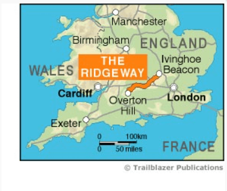
An 87-mile (139km) National Trail, the Ridgeway runs from Overton Hill near Avebury in Wiltshire to Ivinghoe Beacon in Buckinghamshire. Part of this route follows Britain’s oldest road, dating back millennia. Taking 5-7 days, this is not a difficult walk and the rewards are many: rolling countryside, Iron Age forts, Neolithic burial mounds, white horses carved into the chalk downs and picturesque villages.
With accommodation, pubs and restaurants in detailed guides and maps to 24 towns and villages including Marlborough and Avebury.
- Includes 53 detailed walking maps
- Unique mapping features
- Itineraries for all walkers
- Practical information for all budgets
- Downloadable GPS waypoints
Artikelen uit dezelfde regio

Wandelgids Cotswolds - Heart of the Cotswolds - Rucksack Readers • 9781913817268
Wandelgids Cotswolds - Heart of the Cotswolds - Rucksack Productomschrijving: The Cotswolds AONB is quintessentially English, with its rich cultural history, medieval ‘wool’ churches and charming domestic architecture of stone, slate and thatch. The book offers three options for walking in the heart of this wonderful area: a 94-mile (151-km) grand tour starting from Cheltenham, and two sh…

Wandelkaart 158 Newbury & Hungerford- Berkshire - OSI • 9780319243510
Wandelkaart Newbury & Hungerford - Berkshire England Omvat ook: Lambourn & Kintbury Productomschrijving: Kaart nummer 158 in de OS Explorer kaarten reeks omvat de streek rond Newbury en de North Wessex Downs AONB - Area of Outstanding Natural Beauty. De Lambourn Valley Way loopt van Newbury tot Lambourn noordwaarts naar langs de rivier Lambourn. Andere hoogtepunten van het gebied zijn …

Wandelkaart 184 Salisbury & The Plain- Wiltshire England - OSI • 9780319475072
Wandelkaart Salisbury & The Plain - Wiltshire England Productbeschrijving: Kaart nummer 184 in de OS Landranger kaarten reeks is ideaal voor het plannen van daguitstapjes in- en rond het gebied van Salisbury. Grote spectaculaire uitzichten voor een unieke blik op de omgeving. Hoogtepunten van het gebied zijn onder andere: Stonehenge, Salisbury, pastorie Down National Nature Reserve en Old …
Reisgids Cotswolds AONB - Rough Guides • 9781839059728
The Cotswolds AONB - Rough Guides Productomschrijving: Deze omvat het Cotswolds gebied in zuid-oost Engeland. Een gebied van uitmuntend natuurschoon, of in andere meer lokalere woorden, een AONB area, of Area of Outstanding Natural Beauty. Bij ons is dat bijvoorbeeld de westhoek, het Zwin, enz... Deze reisgids biedt u deze regio inclusief de locaties van Stratford-Uppon-Avon & Oxford die a…
Wandelkaart 156 Chippenham & Bradford-on-Avon- Wiltshire - OSI • 9780319470282
Wandelkaart Chippenham & Bradford-on-Avon - Wiltshire Omvat ook: Trowbridge & Melksham. Productbeschrijving: Kaart nummer 156 in de OS Explorer reeks heeft betrekking op een gedeelte van de North Wessex Downs AONB en Cotswolds rond Melksham en Bradford-on-Avon. Hoogtepunten van het gebied zijn de steden Chippenham en Trowbridge samen met de Macmillan way en White Horse Trail. De OS Exp…