

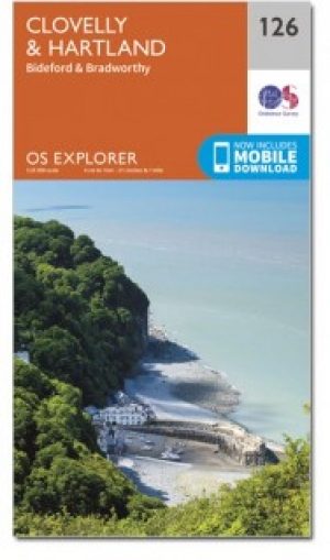
Wandelkaart 126 Clovelly & Hartland Devon - OSI
Omvat Clovelly- Bideford- Hartland & Bradworthy


Korte omschrijving
Wandelkaarten Devon, England van Ordnance Survey. Ideaal voor tochten in England.
Wandelkaart Clovelly & Hartland - Devon England - OSI Productbeschrijving: - Bideford & Bradworthy. 126 / Clovelly & Hartland, Devon, England - Kaart blad nummer 126 in de OS Explorer re...

Specificaties
- Uitgever: Ordnance Survey
- ISBN-13: 9780319243220
- HOOFDCATEGORIEËN: Wandelkaart
- Activiteiten: Wandelen, Hiking & Trekking
- Regio: Devon, England
- Land: England
- TOPO's & Stafkaarten: Topografisch wandelen
- Schaal: 1:25000
- Taal: Engels
- Reeks/Serie: Explorer Series OS
- De Engelse Graafschappen: Devon
Volledige omschrijving
Wandelkaart Clovelly & Hartland - Devon England - OSI
Productbeschrijving: - Bideford & Bradworthy.
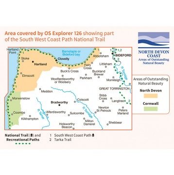
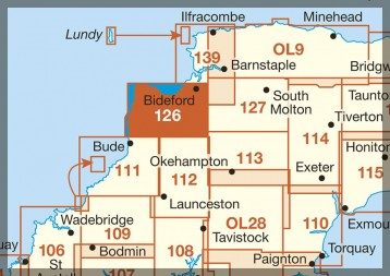
126 / Clovelly & Hartland, Devon, England - Kaart blad nummer 126 in de OS Explorer reeks omvat Clovelly, Bideford, Hartland, Bradworthy en great Torrington. Hoogtepunten van het gebied zijn onder andere: Noord-Devon en Cornwall AONB, rivier Torridge en Tamar, Hartland punt, Barnstaple en Bideford Bay en Coombe. Omvat ook een deel van de South West Coast Path. De OS Explorer kaart voor Clovelly & Hartland is beschikbaar in zowel de standaard papieren versie als de weerbestendige 'Actief' versie.
126 / Clovelly & Hartland, Devon, England - Map sheet number 126 in the OS Explorer series covers Clovelly, Bideford, Hartland, Bradworthy and Great Torrington. Highlights of the area include: North Devon and Cornwall AONB, River Torridge and Tamar, Hartland Point, Barnstaple and Bideford Bay and Coombe. Also includes part of the South West Coast Path. The OS Explorer map for Clovelly & Hartland is available in both the standard paper version and weatherproof 'Active' version.
Locatie op kaart
Gekoppelde artikelen
Wandelkaart 126 Clovelly & Hartland Devon - OSI • 9780319243220
standaard versieWandelkaart Clovelly & Hartland - Devon England - OSI Productbeschrijving: - Bideford & Bradworthy. 126 / Clovelly & Hartland, Devon, England - Kaart blad nummer 126 in de OS Explorer reeks omvat Clovelly, Bideford, Hartland, Bradworthy en great Torrington. Hoogtepunten van het gebied zijn onder andere: Noord-Devon en Cornwall AONB, rivier Torridge en Tamar, Hartland punt, Barnstaple e…

Wandelkaart 126 Clovelly & Hartland- Devon England - OSI • 9780319470015
weatherproof versieWandelkaart Clovelly & Hartland - Devon England - OSI Productbeschrijving: Kaart nummer 126 in de OS Explorer reeks omvat Clovelly, Bideford, Hartland, Bradworthy en great Torrington. Hoogtepunten van het gebied zijn onder andere: Noord-Devon en Cornwall AONB, rivier Torridge en Tamar, Hartland punt, Barnstaple en Bideford Bay en Coombe. Ook omvat een deel van de South West Coast Path. De …
Artikelen uit dezelfde regio

Wandelgids Part 3 SWCP Map Booklet PLymouth to pool - Cicerone • 9781786312006
Map booklet South West Coast Path - Cicerone Productomschrijving: Kaart van een deel van het zuidelijke deel van het 630 mijl (1014 km) lange South West Coast Path National Trail. Omvat het pad van Plymouth naar Poole langs de kustlijn van Devon en Dorset. Dit handige en compacte boekje met Ordnance Survey 1:25.000 kaarten toont de route en biedt alle kaarten die je nodig hebt om het pad i…

Wandelgids 15 Short Walks Dartmoor South - Cicerone • 9781786311924
Wandelgids Short Walks Dartmoor South - Cicerone Productomschrijving: Would you like to explore the best of Ivybridge and Princetown? This guidebook covers 15 of Dartmoor's best short walks including Cox Tor, Great Staple Tor, Merrivale, Drizzlecombe, Ditsworthy, Sheepstor and Wistman's Wood. Why choose this guidebook? - Walks under three hours, plus one challenge route - Easy to…

Wandelkaart 202 Torbay - South Dartmoor NP - OSI • 9780319263976
Wandelkaart Torbay - South Dartmoor NP - OSI Productomschrijving: De Landranger kaart nummer 202 is een kaart voor alle doeleinden, boordevol informatie om u te helpen een gebied echt te leren kennen. Elke kaart bestrijkt een gebied van 40 km bij 40 km. Deze kaart van Torbay & South Dartmoor omvat ook: Totnes, Salcombe, Totcross, Brixham, Paignton, Torquay, Newton Abbot, Ivybridge, Ho…
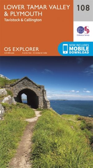
Wandelkaart 108 Lower Tamar Valley & Plymouth - OSI • 9780319243107
Wandelkaart Lower Tamar Valley & Plymouth - England - OSI Omvat ook: Tavistock & Callington Productbeschrijving: Kaart nummer 108 in de OS Explorer kaarten reeks omvat de zuidkust tussen Devon en Cornwall rond Plymouth. Met een deel van Dartmoor National Park, evenals de gebieden van uitstekende natuurlijke schoonheid AONB. Samen met Cornwall, Zuid-Devon & de Tamar vallei is dit een ge…
Reisgids Go Slow Devon South & Dartmoor - Bradt Travel guides • 9781804691007
Devon South & Dartmoor NP - Bradt Productomschrijving: Deze nieuwe, grondig bijgewerkte derde editie van South Devon and Dartmoor maakt deel uit van Bradt's kenmerkende 'Slow travel' serie van gidsen over Britse regio's en biedt een diepgaande verkenning van een van de meest populaire gebieden van Engeland. Geschreven door Hilary Bradt, wijlen Janice Booth, en Gill en Alistair Campbell, bl…