

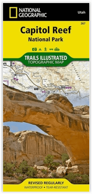
Wandelkaart 267 Capitol Reef NP Utah - Natgeo
National Geographic's Trails Illustrated kaart van Capitol Reef
Korte omschrijving
Wandelkaarten Utah, USA van National Geographic. Ideaal voor tochten in Verenigde Staten van Amerika (USA).
Wandelkaart Capitol Reef NP Utah - Nat Geo Productomschrijving: Capitol Reef National Park is een verborgen juweel gelegen in de Waterpocket Fold, een rimpel in de aarde die zich uitstrekt b...

Specificaties
- Uitgever: National Geographic
- ISBN-13: 9781566956703
- HOOFDCATEGORIEËN: Wandelkaart
- Activiteiten: Wandelen, Hiking & Trekking
- Auteur: National Geographic
- Regio: Utah, USA
- Land: Verenigde Staten van Amerika (USA)
- Nationale parken: Capitol Reef NP, Utah Verenigde staten
- TOPO's & Stafkaarten: Topografisch wandelen
- Schaal: 1:75000
- Taal: Engels
Volledige omschrijving
Wandelkaart Capitol Reef NP Utah - Nat Geo
Productomschrijving: Capitol Reef National Park is een verborgen juweel gelegen in de Waterpocket Fold, een rimpel in de aarde die zich uitstrekt bijna 100 mijl door het zuiden-centrale rode rots land van Utah. National Geographic's Trails Illustrated kaart van Capitol Reef biedt ongeëvenaarde details van het park om tegemoet te komen aan de behoeften van zowel de amateur als de ervaren outdoor enthousiastelingen. Gemaakt in samenwerking met lokale landbeheerders, toont deze deskundig onderzochte kaart het gehele park, evenals aangrenzende gebieden van belang, waaronder Anasazi State Park en delen van Fishlake National Forest, Grand Staircase-Escalante National Monument, en Dixie National Forest.
Omvat: Anasazi State Park en deel van Fishlake National Forest, Grand Staircase-Escalante National Monument, en Dixie National Forest, Capitol Reef National Park, Circle Cliffs, Dixie National Forest, Fishlake National Forest, Glen Canyon National Recreation Area, Henry Mountains, Miners Mountain, Mount Pennell, South Desert, Waterpocket Fold..
Engelse omschrijving: Capitol Reef National Park is a hidden gem located in the Waterpocket Fold, a wrinkle in the earth that extends nearly 100 miles through south-central Utah's red rock country. National Geographic's Trails Illustrated map of Capitol Reef provides unmatched detail of the park to meet the needs of amateur and experienced outdoor enthusiasts alike. Created in partnership with local land management agencies, this expertly researched map features the entire park as well as adjacent areas of interest including Anasazi State Park and portions of Fishlake National Forest, Grand Staircase-Escalante National Monument, and Dixie National Forest.
This map can guide you off the beaten path and back again with miles of mapped trails including a portion of the Great Western Trail, and recommended equestrian and bike routes. Trails are marked with mileage between intersections. A summary chart of fifteen Fruita day hiking routes, contact info, safety tips, and information about road tours, geology of the park, and recreation activities are included to help guide you in enjoying all the park has to offer. Some of the noted recreation features include scenic viewpoints, trailheads, campgrounds, and equestrian staging areas. The map base includes contour lines and elevations for summits.
Every Trails Illustrated map is printed on "Backcountry Tough" waterproof, tear-resistant paper. A full UTM grid is printed on the map to aid with GPS navigation.
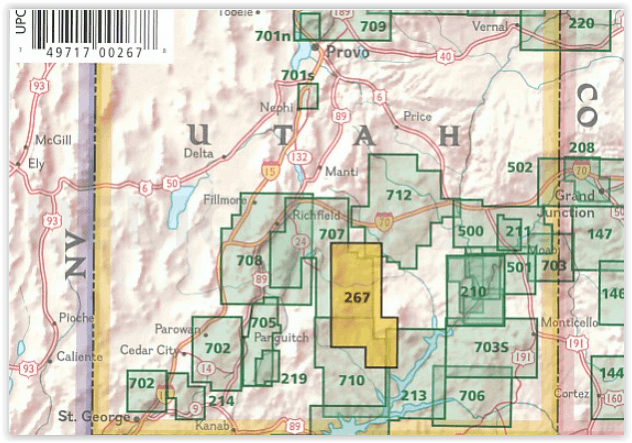
Overzichtskaarten

NAT GEO Utah trail maps
NAT GEO Utah trail maps

Producten op de overzichtskaart
Klik op een product om naar de detailpagina te gaan.
- Wandelkaart 210 Canyonlands NP - Utah - Natgeo
- Wandelkaart 211 Arches National Park- Utah - Natgeo
- Wandelkaart 214 Zion National Park - Natgeo
- Wandelkaart 219 Bryce Canyon NP Utah - Natgeo
- Wandelkaart 267 Capitol Reef NP Utah - Natgeo
- Wandelkaart 702 Cedar Mountain - Utah USA - Nat Geo
- Wandelkaart 703 Manti-La Sal National forest - Natgeo
- Wandelkaart 704 Flaming Gorge- Recreational Area - Utah
- Wandelkaart 705 Mount Dutton & Aquarius Plateau - Nat Geo
- Wandelkaart 213 Glen Canyon & Capitol Reef NP - Nat Geo
Artikelen uit dezelfde regio

Wandelkaart 709 Wasatch Front North Utah - Nat Geo • 9781566953702
Wasatch Front North - Utah - Nat Geo Omvat: Bountiful, Centerville, Cottonwood Heights, Currant Creek Peak, Daniels Canyon, Deer Creek Reservoir, Draper, Highland, Holladay, Lindon, Lone Peak Wilderness, Midvale, Mount Olympus Wilderness, Mount Timpanogos, Mount Timpanogos Wilderness, Murray, North Salt Lake, Orem, Pleasant Grove, Provo, Provo River, Rockport Lake, Salt Lake City, South Sa…

Reisgids Utah - Insight guides ENG • 9781839053252
Reisgids Utah - Insight guides ENG Productomschrijving: Deze Insight Guide is een rijk geïllustreerde inspirerende reisgids voor Utah en een prachtig souvenir van uw reis. Perfect voor reizigers die op zoek zijn naar een diepere duik in de geschiedenis en cultuur van de bestemming en ideaal om u te inspireren en te helpen bij het plannen van uw reis. Met zijn grote selectie van beziens…
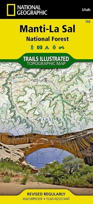
Wandelkaart 703 Manti-La Sal National forest - Natgeo • 9781566953771
TOPO Wandelkaart 703 - Manti-La Sal National forest - Nat Geo Productomschrijving: Het Manti–La Sal National Forest omvat meer dan 4,900 km, en is gelegen in centraal- en zuidoostelijke deel van Utah en het extreme westelijke deel van Colorado. Engelse omschrijving: Expertly researched and created in cooperation with the U.S. Forest Service, Bureau of Land Management and others, Natio…
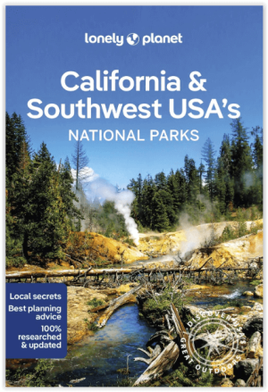
Wandelgids California & Southwest USA's NP's - Lonely Planet • 9781838696061
Wandelgids California & Southwest USA's National Parks Productomschrijving: Lonely Planet's California and Southwest USA's National Parks is uw paspoort voor het meest actuele advies over wat je moet zien en overslaan. Wandel door de Grand Canyon, bewonder Sequoia en jaag op watervallen in Yosemite; allemaal met je vertrouwde reisgenoot. Duik in het hart van de nationale parken van Califor…

Wandelkaart 702 Cedar Mountain - Utah USA - Nat Geo • 9781566953061
Wandelkaart Cedar Mountain - Utah USA - Nat Geo Omvat: Ashdown Gorge Wilderness, Brian Head, Dixie National Forest, Kolob Terrace, Little Salt Lake, Markagunt Plateau, Panguitch Lake, Parowan Valley, Pine Valley Mountain Wilderness, Pine Valley Mountains, Signal Peak. Engelse omschrijving: Cedar City is the headquarters of the Dixie National Forest which is a two-million-acre, 170-mile…