

HOOFDCATEGORIEËN
Activiteiten
Reeks/Serie:
Regio
AONB - Area of Outstanding Beauty
De Engelse Graafschappen
Fietsen
Historische wandelroutes
Iconische Wandelroutes
Lange afstand wandelroutes
Iconische Bergketens van Europa
Nationale parken
TOPO's & Stafkaarten
UNESCO werelderfgoed
Waterafstotende kaart
Uitgever


 De National Trails van Engeland – wandelen door geschiedenis en natuur
De National Trails van Engeland – wandelen door geschiedenis en natuur,
De National Trails van Engeland vormen het hart van de Britse wandelcultuur. Dit netwerk van langeafstandsroutes brengt je door glooiende heuvels, oude pelgrimspaden en kustgebieden waar elke stap een stukje geschiedenis vertelt. Deze paden zijn perfect bewegwijzerd en doordrenkt van traditie, met telkens een unieke mix van landschap en erfgoed.
Een absolute topper is de South West Coast Path, die meer dan duizend kilometer langs de zuidwestkust van Cornwall slingert. Van de steile kliffen van Cornwall tot de zandstranden van Devon, deze route biedt telkens weer uitzicht op zee, vuurtorens en vissershavens zoals St Ives en Padstow. Meer landinwaarts ligt de Cotswold Way, een klassieker door een landschap van honingkleurige dorpen, wijngaarden en kalksteenheuvels. Dorpen als Broadway, Winchcombe en Painswick zijn geliefde haltes, vol Engelse charme. Wie zijn route goed wil voorbereiden, vindt inspiratie bij Europa's meest Iconische Wandelroutes, en praktische hulp in Wandelkaarten Engeland. Wie meer wil weten over de regio’s waar deze trails doorheen lopen, vindt achtergrondinformatie op De Engelse Graafschappen.
Van de kalme valleien van de Cotswolds AONB tot de ruige kliffen van Cornwall — de National Trails van Engeland tonen de ziel van het land: authentiek, tijdloos en uitnodigend voor elke wandelaar.

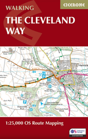
Wandelgidse The Cleveland Way - Trailblazer • 9781912716494
The Cleveland Way - Trailblazer Productomschrijving: De Cleveland Way is een "National Trail" in het prachtige wilde landschap van het North York Moors National Park. Het loopt 107,4 mijl (127,9 km) Van Helmsley bij Thirsk rond de westelijke rand van het park om de kust bij Saltburn-by-the-Sea te bereiken. Vervolgens gaat de route langs de oostelijke rand van het park zuidwaarts langs de k…

Wandelgids North Downs Way - Trailblazer Publications • 9781912716500
Wandelgids North Downs Way - Trailblazer Productomschrijving: The North Downs Way, from Farnham to Dover is a 131-mile (211km) National Trail. (British Walking Guide) 84 trail maps 16 town plans 50 colour photos 120mm x 180mm, 5" x 7" The North Downs Way, a 131-mile (211km) National Trail runs from Farnham in Surrey to Dover in Kent via Canterbury, winding its way through…
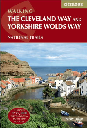
Wandelgids The Cleveland Way & Yorkshire Wolds Way - CIcerone • 9781786312211
Wandelgids The Cleveland Way & Yorkshire Wolds Way - CIcerone Productomschrijving: De vernieuwede wandelgids over de Cleveland Way en Yorkshire Wolds Way National Trails, plus de Tabular Hills Walk. De drie routes lopen door het North York Moors National Park, langs de kust en op het rustige platteland en kunnen worden samengevoegd tot een gemakkelijke rondwandeling van meer dan 400 km. In…
Wandelgids The Cleveland Way Map Booklet - Cicerone • 9781786312228
The Cleveland Way Map Booklet - Cicerone Productomschrijving: Kaartboekje van de Cleveland Way National Trail, een 177 km lange wandeling rond het North York Moors National Park. Dit boekje is inbegrepen bij de Cicerone gids voor de Cleveland Way en de Yorkshire Wolds Way en toont de volledige route van de Cleveland Way op OS 1:25.000 kaarten. Dit kaart Boekje zit reeds gratis bijgevoe…

Wandelkaart South West Coast Path 2 - Harvey maps • 9781851376827
South West Coast Path 2 - Harvey maps Productomschrijving: Het South West Coast path is een 1014 km lang langeafstandspad en het langste nationale pad in Engeland. Het pad strekt zich uit van Minehead in Somerset tot Poole in Dorset, inclusief Land's End en de prachtige zuidkust van Cornwall. Dit deel van de route brengt u van St-Ives naar Plymouth. Engelse omschrijving: The Sou…

Wandelkaart South West Coast Path 3 - Harvey Maps • 9781851376834
South West Coast Path - Harvey Maps Productomschrijving: Het South West Coast path is een dikke 1014 km lang en omvat het volledige South-West-England met daarin Devon & Corwall. Het pad is een National trail en behoort tot de langste routes van Engeland. De route start in Minehead in Somerset en loopt de volledige kust af tot in Poole in Dorset. OPGELET: deze kaart omvat het laatste deel …

Wandelkaart 4009 Hadrian's Wall Path - Nat Geo • 9781566959421
Wandelkaart Hadrian's Wall Path - National Geographic Productomschrijving: As a demonstration of the Roman Empire's power and strength, Emperor Hadrianus conceived the idea to build a wall to deter attacks on his Roman territory Britannia. At the time — and even today — building a 73-mile (135-kilometer) long wall, standing 5 meters (16 feet) high and 3 meters (10 feet) wide was an excepti…
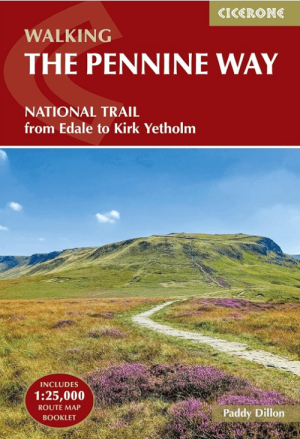
Wandelgids The Pennine Way from Edale to Kirk Yetholm - Cicerone • 9781786311313
The Pennine Way from Edale to Kirk Yetholm - Cicerone Productomschrijving: Guidebook to the Pennine Way National Trail with OS map booklet. The 420 km route from Edale to Kirk Yetholm takes three weeks to walk and is suitable for fit and experienced long distance walkers. The route crosses the Peak District, Yorkshire Dales and North Pennines National Parks. Includes separate OS 1:25,000 …
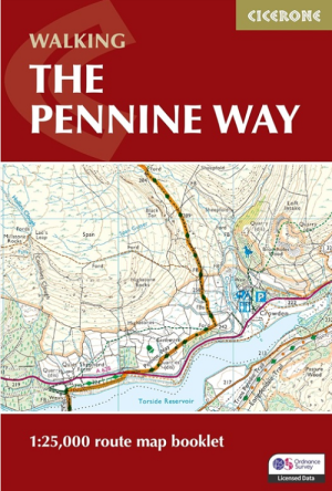
Wandelgids Map Booklet Pennine Way - Cicerone • 9781786311412
Map Booklet Pennine Way - Cicerone Productomschrijving: Map of the 270 miles (435km) Pennine Way National Trail, between Edale in the Peak District and Kirk Yetholm in the Scottish Borders. This booklet is included with the Cicerone guidebook to the trail, and shows the full route on OS 1:25,000 maps. This popular long-distance route typically takes three weeks to complete. Seasons: …

Wandelgids The Ridgeway National Trail - Trailblazer Publ. • 9781912716524
The Ridgeway National Trail - Trailblazer Publications Productomschrijving: The Ridgeway: Avebury to Ivinghoe Beacon - 53 maps - 46 colour photos, - 4pp colour flower & butterfly guide An 87-mile (139km) National Trail, the Ridgeway runs from Overton Hill near Avebury in Wiltshire to Ivinghoe Beacon in Buckinghamshire. Part of this route follows Britain’s oldest road, dating b…
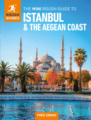
Reisgids Mini Roughguide to Istanbul & the Aegean Coast • 9781835292730
Reisgids Istanbul & the Aegean Coast - Rough Guides Productomschrijving: This mini pocket Istanbul and the Aegean Coast travel guidebook is perfect for travellers looking for essential information about Istanbul and the Aegean Coast. It provides details on key places and main attractions, along with a selection of itineraries, recommendations for restaurants and top tips on how to make the…

Fietsgids Pennine Bridleway Cycling guide - Vertebrate Publ. • 9781839810428
Pennine Bridleway Cycling guide - Vertebrate Productomschrijving: From Derbyshire through the Yorkshire Dales to Cumbria Pennine Bridleway by Hannah Collingridge is a guidebook to this National Trail taking you from Derbyshire through the Yorkshire Dales to Cumbria, following the Pennine Hills AONB. Together with stunning photography, the route features Ordnance Survey 1:50,000 maps, e…

Wandelkaart Hadrian's Wall Path - Vertebrate Publ. • 9781839810312
Hadrian's Wall Path - Vertebrate Productomschrijving: Easy-to-use folding map and essential information, with custom itinerary planning for walkers, trekkers, fastpackers and trail runners Hadrian's Wall Path Guidemap from Vertebrate Publishing is a lightweight, waterproof, durable and easy-to-use folding map with 1:40,000-scale mapping for the east to west HWP route. Includes route va…
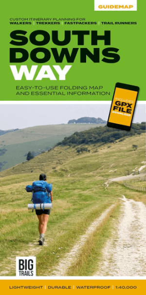
Wandelkaart South Downs Way - Vertebrate Publ. • 9781839810305
Wandelkaart South Downs Way - Vertebrate Productomschrijving: Easy-to-use folding map and essential information, with custom itinerary planning for walkers, trekkers, fastpackers and trail runners The South Downs Way Guidemap from Vertebrate Publishing is a lightweight, waterproof, durable and easy-to-use folding map with 1:40,000-scale mapping for the linear SDW route. Includes an elevati…
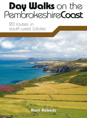
Wandelgids Day Walks on the Pembrokeshire Coast - Vertebrate publ • 9781910240984
Day Walks on the Pembrokeshire Coast - Vertebrate Productomschrijving: 20 routes in south-west Wales Day Walks on the Pembrokeshire Coast features 20 classic coastal routes between 6.5 miles and 13 miles (10.4km and 20.8km) in length, suitable for hillwalkers of all abilities. Local author and walker Harri Roberts shares his favourite walks in the national park, including a meander al…
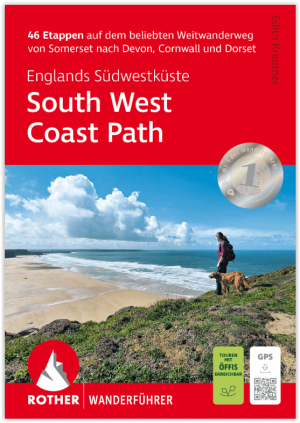
Wandelgids South West Coast Path - Englands Südwestküste - Rother • 9783763348794
Wandelgids South West Coast Path - Rother Productomschrijving: De South West Coast Path – kortweg SWCP – in het zuidwesten van Engeland is de droom van elke langeafstandwandelaar. De route strekt zich uit over meer dan 1000 kilometer langs de spectaculaire kusten van Somerset, Devon, Cornwall en Dorset. Deze route laat u de ruige schoonheid van Engeland ervaren met zijn dramatische kliffen…
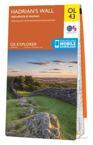
Wandelkaart OL43 Hadrian's Wall- Haltwhistle & Hexham - OS • 9780319263624
Wandelkaart Hadrian's Wall- Haltwhistle & Hexham - OS Productomschrijving: Topografische wandelkaart van Hadrian's Wall- Haltwhistle & Hexham. Omvat: Haltwhistle & Hexham, historic Hadrian's Wall path across Northern England, with parts of Northumberland National park & The Pennine Way. Ontdek de OL-serie van Ordnance Survey: De OL-serie (Outdoor Leisure) van Ordnance Survey is …

Wandelgids 025 Pathfinder guides Thames Valley & Chilterns - OS • 9780319090053
Wandelgids The Thames Valley & The Chilterns AONB Productomschrijving: The Chilterns AONB form part of the long line of chalk hills stretching intermittently across southern and eastern England. It is an area characterised by beech woods and dry valleys, and these natural features are explored in the 28 routes available in this walks guidebook. The Thames Valley is steeped in history,…

Wandelgids 069 Pathfinder guides South West England Coastal walks • 9780319091135
Wandelgids South West England Coastal walks - OS Productomschrijving: Immerse yourself in 28 beautiful walks along the South West Coast of England with the OS Pathfinder Guidebooks, graded by length and ranging from 3 to 9 miles. The routes range from extended strolls to longer hikes, something for all levels! Each walk includes a detailed description, an OS map, GPS waypoints and notes of…

Wandelgids Hadrian's Wall Path - Rucksack Readers • 9781913817312
Wandelgids Hadrian's Wall Path Productomschrijving: Hadrian's Wall Path runs for 86 miles (135 km) between Bowness-on-Solway and Wallsend (Newcastle) along the line of the Roman Wall completed in AD122 under the Emperor Hadrian. This National Trail crosses northern England from Irish Sea to North Sea and offers many chances to look at the forts, milecastles and interpretation centres withi…
De National Trails van Wales – grenzen, kust en Keltisch erfgoed
De National Trails van Wales – grenzen, kust en Keltisch erfgoed,
Het heuvelachtige landschap van Wales vormt het decor van enkele van de mooiste wandelroutes van Groot-Brittannië. De National Trails van Wales combineren bergen, kliffen en kastelen tot een mozaïek van natuur en cultuur. Elk pad biedt een blik op de trotse Keltische ziel van het land, waar legendes en landschap elkaar raken.
De beroemdste is de Offa’s Dyke Path, die van Chepstow tot Prestatyn de oude grens volgt tussen Engeland en Wales. De route loopt over kammen, valleien en dorpen als Hay-on-Wye, bekend om zijn boekenmarkten. Wie hier wandelt, stapt letterlijk door 1200 jaar geschiedenis. Aan de zuidwestkust ligt de Pembrokeshire Coast Path, met zijn dramatische kliffen, verlaten baaien en kleurrijke kustdorpen zoals Tenby en St Davids. Dit pad biedt voortdurend uitzicht op de oceaan, zeevogels en ruige rotsformaties – puur Welshe natuurkracht.
Voor wie wil plannen of inspiratie zoekt, bieden de Iconische Wandelroutes en Wandelgidsen Engeland een overzicht van de mooiste trajecten, terwijl onze Wandelkaarten Engeland zorgen voor betrouwbare navigatie. Over de regio’s die deze routes verbinden lees je meer op De Engelse Graafschappen.
Wie eenmaal door de valleien en kliffen van Wales heeft gewandeld, begrijpt waarom de National Trails van Wales zoveel lof krijgen: ze verbinden natuur, erfgoed en stilte op een manier die enkel hier mogelijk is.
De mooiste langeafstandsroutes van het Verenigd Koninkrijk
De mooiste langeafstandsroutes van het Verenigd Koninkrijk,
De National Trails UK vormen samen een netwerk van paden dat Engeland en Wales doorkruist, van noord tot zuid en van kust tot kust. Deze routes zijn meer dan wandelpaden: het zijn vensters op de ziel van het Britse landschap. De Pennine Way is de oerroute – de oudste National Trail van Groot-Brittannië. Ze loopt van Edale in Derbyshire tot Kirk Yetholm aan de Schotse grens. Wandelaars trekken over de open heidevelden van de Yorkshire Dales, de ruige hoogten van de Northern Pennines en de stille dalen van Northumberland. In het zuiden volgt de North Downs Way het spoor van middeleeuwse pelgrims. De route voert van Farnham naar Dover, langs oude kerken, bossen en uitkijkpunten over de iconische White Cliffs.
Voor wie inspiratie zoekt, bieden onze Iconische Wandelroutes een overzicht van de beroemdste Britse trajecten. Wie zijn reis praktisch wil plannen, kan terecht bij Wandelkaarten Engeland. Meer informatie over de graafschappen die deze routes doorkruisen vind je op De Engelse Graafschappen. Van de kustpaden van Dorset tot de kale heuvels van de Pennines – de National Trails UK tonen het Verenigd Koninkrijk op zijn meest puur en avontuurlijk.