

Wandelgids 044 Pathfinder guides Essex England - OS
Burnham- Epping Forest- Blackwater Estuary- The Naze...


Korte omschrijving
Wandelgidsen Essex South England van Ordnance Survey. Ideaal voor tochten in England.
Wandelgids Essex England - OS Productomschrijving: This book has 28 circular, graded walks all around Essex. The routes range from extended 4.8km (3 miles) up to 15.6km (10 miles), so there...

Specificaties
- Uitgever: Ordnance Survey
- ISBN-13: 9780319091166
- HOOFDCATEGORIEËN: Wandelgids
- Activiteiten: Wandelen, Hiking & Trekking
- Regio: Essex South England
- Land: England
- Taal: Engels
- Reeks/Serie: Outstanding Circular Walks, Pathfinder Series, OS
- De Engelse Graafschappen: Essex
Volledige omschrijving
Wandelgids Essex England - OS
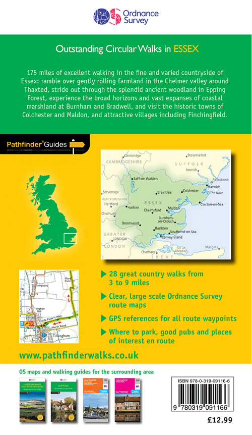
Productomschrijving: This book has 28 circular, graded walks all around Essex. The routes range from extended 4.8km (3 miles) up to 15.6km (10 miles), so there is something for everyone of all abilities. Each walk includes a detailed description, an extract of the OS Explorer 1:25k map, GPS waypoints and key features to look out for. You can also find information on parking, refreshments and more.
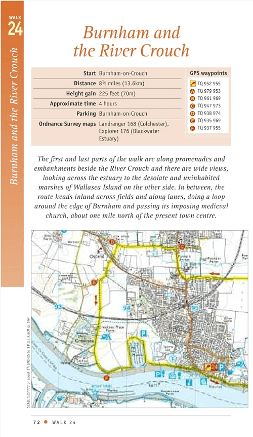
The Essex landscape gently undulates, with the hilliest country is in the north and west, near the Hertfordshire and Cambridgeshire borders. On the marshes of Essex, for example, there is a genuine feeling of solitude that is hard to find anywhere else in southern England. Routes include Burnham, Epping Forest, the Blackwater Estuary, The Naze, Stour Valley and two country parks.

Overzichtskaarten

Overzicht Pathfinder guides - OS
Overzicht Pathfinder guides - OS

Producten op de overzichtskaart
Klik op een product om naar de detailpagina te gaan.
- Wandelgids 001 Pathfinder guides South Devon & Dartmoor NP - OS
- Wandelgids 003 Pathfinder guides Isle of Skye - OS
- Wandelgids 004 Pathfinder guides Cairngorms NP - OS
- Wandelgids 005 Pathfinder guides Cornwall England - OS
- Wandelgids 006 Pathfinder guides Cotswolds AONB - OS
- Wandelgids 007 Pathfinder guides Fort William & Glen Coe - OS
- Wandelgids 008 Pathfinder guides Kent - OS
- Wandelgids 009 Pathfinder guides Exmoor NP & the Quantocks - OS
- Wandelgids 010 Pathfinder guides Snowdonia NP Wales - OS
- Wandelgids 011 Pathfinder guides Dorset England - OS
- Wandelgids 012 Pathfinder New Forest & South Downs NP Hampshire
- Wandelgids 015 Pathfinder guides Yorkshire Dales NP - OS
- Wandelgids 018 Pathfinder guides Brecon Beacons Wales - OS
- Wandelgids 019 Pathfinder guides Dumfries & Galloway - OS
- Wandelgids 020 Pathfinder guides Sherwood Forest - OS
- Wandelgids 022 Pathfinder guides More Lake District - OS
- Wandelgids 023 Pathfinder guides Loch Lomond, Trossachs NP - OS
- Wandelgids 025 Pathfinder guides Thames Valley & Chilterns - OS
- Wandelgids 026 Pathfinder guides Dartmoor National Park - OS
- Wandelgids 027 Pathfinder Perthshire "big county" Angus & Five OS
- Wandelgids 028 Pathfinder guides North York Moors NP - OS
- Wandelgids 029 Pathfinder guides Wye Valley AONB & Forrest of Dean
- Wandelgids 030 Pathfinder guides Loch Ness & Iverness - OS
- Wandelgids 031 Pathfinder guides Oban, Mull & Kintyre - OS
- Wandelgids 034 Pathfinder guides Pembrokeshire Wales - OS
- Wandelgids 035 Pathfinder guides Northumberland- Scottish Borders
- Wandelgids 039 Pathfinder Durham, North Pennines & Tyne & Wear OS
- Wandelgids 041 Pathfinder guides Central Wales - OS
- Wandelgids 042 Pathfinder guides Cheshire England - OS
- Wandelgids 044 Pathfinder guides Essex England - OS
- Wandelgids 045 Pathfinder guides Norfolk - OS
- Wandelgids 046 Pathfinder guides Aberdeen & Royal Deeside - OS
- Wandelgids 047 Pathfinder Edinburgh, Pentlands & Lothians - OS
- Wandelgids 048 Pathfinder guides Suffolk East England - OS
- Wandelgids 049 Pathfinder guides Vale of York East England - OS
- Wandelgids 050 Pathfinder guides Lincolnshire & the Wolds - OS
- Wandelgids 051 Pathfinder guides Cambridgeshire & The Fens - OS
- Wandelgids 053 Pathfinder guides Lancashire NW En England - OS
- Wandelgids 054 Pathfinder guides Hertfordshire & Bedfordshire- OS
- Wandelgids 055 Pathfinder guides Gower, Swansea & Cardiff - OS
- Wandelgids 060 Pathfinder guides Lake District NP - OS
- Wandelgids 063 Pathfinder guides Peak District England - OS
- Wandelgids 064 Pathfinder guides South Pennines - OS
- Wandelgids 065 Pathfinder guides Surrey England - OS
- Wandelgids 066 Pathfinder guides West Sussex & South Downs - OS
- Wandelgids 067 Pathfinder guides South Downs NP & East Sussex- OS
- Wandelgids 068 Pathfinder guides Devon North & Mid - OS
- Wandelgids 069 Pathfinder guides South West England Coastal walks
- Wandelgids 071 Pathfinder guides High Fells of Lakeland - OS
- Wandelgids 073 Pathfinder guides More Peak District - OS
Artikelen uit dezelfde regio

Wandelkaart 176 Blackwater Estuary- Essex England - OSI • 9780319470480
Wandelkaart Blackwater Estuary - Essex England Omvat eveneens: Maldon, Burnham-on-Crouch & Southend-on-Sea. Productbeschrijving: OS Explorer kaart 176 omvat de riviermond van de Blackwater in Essex, en omvat Burnham-on-Crouch, beroemd voor zijn zeilsport. Het estuarium is een speciale beschermd gebied, en bied mogelijkheden voor wie geïnteresseerd is in dieren en in het wild, vooral vo…

Wandelkaart 183 Chelmsford & The Rodings England - OSI • 9780319470558
Wandelkaart Chelmsford & The Rodings - Essex England Omvat ook: Maldon & Witham. Productbeschrijving: Kaart nummer 183 in de OS Explorer reeks heeft betrekking op centraal Essex rond Chelmsford. Dit gebied omvat recreatieve paden zoals de Essex Way, Centenery circle en Three Forests way, samen met de steden Witham, Maldon en Chipping Ongar. De OS Explorer kaart voor Chelmsford & de bes…

Wandelkaart 183 Chelmsford & the Rodings- Essex - OSI • 9780319243763
Wandelkaart Chelmsford & the Rodings - Essex England Productbeschrijving: Maldon & Witham. 183 / Chelmsford & the Rodings, Essex, England - Kaart nummer 183 in de OS Explorer reeks heeft betrekking op centrale Essex rond Chelmsford. Dit gebied omvat recreatieve paden zoals de Essex Way, Centenery cirkel en Three Forests way, samen met de steden Witham, Maldon en Chipping Ongar. De OS …

Wandelkaart 184 Colchester Harwich & Clacton-on-Sea - OSI • 9780319243770
Wandelkaart Colchester - Harwich & Clacton-on-Sea - Essex Productbeschrijving: Harwich & Clacton-on-Sea. 184 / Colchester, Harwich & Clacton-on-Sea, Essex, England - Kaart nummer 184 in de OS Explorer reeks heeft betrekking op het oosten van Essex op de kust van de Noordzee. De Essex Way loopt langs het bovenste gedeelte van de kaart van Harwich, en passeert in de buurt van Colchester…

Wandelkaart 174 Epping Forest & Lee Valley- Essex - OSI • 9780319243671
Wandelkaart Epping Forest & Lee Valley - Essex England Productbeschrijving: Hertford & Harlow. 174 / Epping Forest & Lee Valley, Essex, England - Kaart nummer 174 in de OS Explorer reeks omvat Epping Forest en het gebied naar het Noord Oosten van Londen. Het verdragsgebied van de kaart omvat Hertford en Harlow in het noorden tot Ilford en Tottenham naar het zuiden, en omvat hoogtepunte…