
Wandelkaart 145 Guildford & Farnham- Surrey - OSI
Guildford- Farnham & Surrey England
Korte omschrijving
Wandelkaart Guildford & Farnham- Surrey England Productbeschrijving: Guildford & Farnham- Surrey zijn plaatsen in het bestuurlijke gebied Guildford, in het Engelse graafschap Surrey. 145...

Specificaties
- Uitgever: Ordnance Survey
- ISBN-13: 9780319243381
- HOOFDCATEGORIEËN: Wandelkaart
- Activiteiten: Wandelen, Hiking & Trekking
- Regio: Surrey South England
- Land: England
- Schaal: 1:25000
- Afmeting: 13x23
- Taal: Engels
- Reeks: Explorer Series
Volledige omschrijving
Wandelkaart Guildford & Farnham- Surrey England
Productbeschrijving: Guildford & Farnham- Surrey zijn plaatsen in het bestuurlijke gebied Guildford, in het Engelse graafschap Surrey.
145 / Guildford & Farnham, Surrey, England - Kaart nummer 145 is een all purpose kaart vol gepakt met informatie om u het gebied te helpen leren kennen. De 204 Landranger-kaarten bestrijken het land. Elke kaart heeft een oppervlakte van 40 km door 40 km (25 mijl door 25 mijl) en zoals andere kaarten van Ordnance Survey, National Grid-vierkanten worden verstrekt zodat elke functie een unieke referentienummer kan worden gegeven.
145 / Guildford & Farnham, Surrey, England - These highly detailed maps show all the administrative boundaries, settlements as small as isolated farms, the road network down to unfenced roads and country tracks, and field boundaries (hedges and drystone walls) which make navigation across the countryside much easier. Steep gradients on roads are indicated. Various landmarks, e.g. powerlines, archaeological sites, windmills, churches and lighthouses are shown and additional graphics indicate natural terrain features such as cliffs, scree, mud and vegetation variations.
The contour interval is 5 metres in the lower parts of the country and 10 metres in the uplands, and spot heights are marked. Each map covers an area of 30 x 20km (i.e. approx. 19 x 12 miles), with some double-sided maps covering more, as indicated in the individual descriptions. The maps are fully GPS compatible, with the National Grid shown at 1km intervals and latitude and longitude indicated by margin ticks at 1'.
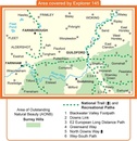
Locatie op kaart
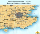
Overzichtskaarten

OSI Explorer & Explorer Active - Zuid England
OSI Explorer & Explorer Active - Zuid England

Producten op de overzichtskaart
Klik op een product om naar de detailpagina te gaan.
- Wandelkaart 117 Cerne Abbas & Bere Regis - Dorset - OSI
- Wandelkaart 118 Shaftesbury & Cranbourne Chase - OSI
- Wandelkaart 129 Yeovil & Sherborne - Somerset - OSI
- Wandelkaart 130 Salisburry & Stonehenge- Wiltshire - OSI
- Wandelkaart 131 Romsey & Andover - Hampshire - OSI
- Wandelkaart 135 Ashdown Forest - East Sussex - OSI
- Wandelkaart 141 Cheddar Gorge & Mendip Hills - OSI
- Wandelkaart 142 Shepton Mallet & Mendip Hills - OSI
- Wandelkaart 143 Warminster & Trowbridge - Wiltshire - OSI
- Wandelkaart 144 Basingstoke - Alton & Whitchurch - OSI
- Wandelkaart 145 Guildford & Farnham- Surrey - OSI
- Wandelkaart 146 Dorking- Box Hill & Reigate- Surrey - OSI
- Wandelkaart 147 Sevenoaks & Tonbridge- Kent - OSI
- Wandelkaart 154 Bristol West & Portishead- Bristol - OSI
- Wandelkaart 155 Bristol & Bath & Bristol Area - OSI
- Wandelkaart 156 Chippenham & Bradford-on-Avon - OSI
- Wandelkaart 157 Marlborough & Savernake Forest - OSI
- Wandelkaart 158 Newbury & Hungerford- Berkshire - OSI
- Wandelkaart 159 Reading- S.E. England - OSI
- Wandelkaart 160 Windsor- Weybridge & Bracknell - OSI
- Wandelkaart 161 London South - OSI
- Wandelkaart 162 Greenwich & Gravesend - OSI
- Wandelkaart 167 Thornbury- Dursley & Yate - England- OSI
- Wandelkaart 168 Stroud- Tetbury & Malmesbury - OSI
- Wandelkaart 169 Cirencester & Swindon - England - OSI
- Wandelkaart 170 Abingdon & Wantage - Oxfordshire - OSI
- Wandelkaart 171 Chiltern Hills West AONB - Wycombe - OSI
- Wandelkaart 172 Chiltern Hills East AONB - Wycombe - OSI
- Wandelkaart 173 London North- England - OSI
- Wandelkaart 174 Epping Forest & Lee Valley- Essex - OSI
- Wandelkaart 179 Gloucester- Cheltenham & Stroud - OSI
- Wandelkaart 180 Oxford- England - OSI
- Wandelkaart 181 Chiltern Hills North AONB- Wycombe - OSI
- Wandelkaart 182 St-Albans & Hatfield- Hertfordshire - OSI
- Wandelkaart OL22 New Forest- Southampton & Ringwood - OSI
- Wandelkaart OL32 Winchester & New Alresford - OSI
- Wandelkaart OL33 Haslemere- Petersfield & Midhurst - OSI
- Wandelkaart OL34 Crawley- Horsham & Cranleigh - OSI
- Wandelkaart OL29 Isle of Wight & Cowes - OSI
- Wandelkaart OL3 Meon Valley- Portsmouth & Gosport - OSI
- Wandelkaart OL3 Meon Valley- Portsmouth & Gosport - OSI
- Wandelkaart OL11 Brighton & Hove - Ordnance Survey
- Wandelkaart OL25 Eastbourne & Beachy Head - OSI
- Wandelkaart OL8 Chichester South Harting- England - OSI
Artikelen uit dezelfde regio

Wandelkaart 146 Dorking Box Hill & Reigate Surrey - OSI • 9780319243398
Wandelkaart Dorking- Box Hill & Reigate - Surrey England Productbeschrijving: Leatherhead & Caterham. 146 / Dorking, Box Hill & Reigate, Surrey, England - Kaart nummer 146 in de OS Explorer reeks omvat Reigate, Leatherhead, Caterham, Dorking, Gatwick Airport, Redhill, Horley, Box Hill, Warlingham en Couldson. Hoogtepunten van het gebied zijn onder andere: Surrey Hills AONB, het E2-pad …

Wandelkaart OL33 Haslemere- Petersfield & Midhurst - OSI • 9780319469514
Wandelkaart Haslemere- Petersfield & Midhurst - Surrey England Omvat ook: Midhurst & Selborne Productbeschrijving: Kaart nummer OL 33 omvat Haslemere, Petersfield, Midhurst en Selborne. Hoogtepunten zijn het Nationaal Park South Downs, de Surrey Hills en de Sussex border path. Andere hoogtepunten van het gebied zijn Greensand way, Hangers way, de rivier Rother en nieuwe Lipchis way Dez…

Wandelgids North Downs Way - Map Booklet - Cicerone • 9781852849559
Wandelgids - North Downs Way - Map Booklet - Cicerone Productomschrijving: Kaart van de 208km, over de North Downs Way National Trail, tussen Farnham en Dover, met inbegrip van een optioneel bezoek aan Canterbury. Dit boekje is opgenomen in de Cicerone gids en toont het volledige parcours op OS 1: 25.000 kaarten. Een van de eenvoudigere nationale routes, dat comfortabel kan worden gelopen …

Reisgids Kent- Sussex & Surrey - Rough Guides • 9781789195804
Reisgids Kent- Sussex & Surrey - Rough Guides Productomschrijving: The brand-new, full-colour Rough Guide to Kent, Sussex & Surrey is the ultimate guide to this beautiful corner of England, with clear maps and lively accounts of both the big cultural attractions and the smaller, quirkier sights, and full coverage of vibrant Brighton and historic Canterbury. The region is fast gaining a…

Fietsgids Cycling in Surrey England - Bradt Travel guides • 9781804691359
Cycling in Surrey - Bradt Travel guides Productomschrijving: De nieuwe fietsgids voor Surrey - is onderdeel van een groeiende serie ontworpen voor in de zadeltas - biedt 21 routes, elk inclusief uitgebreide routebeschrijvingen plus contextuele verkenning van geschiedenis, natuur en cultuur, geschreven door fervent fietser en historicus Ross Hamilton. Elke route is gekoppeld aan OS Explorer…