

Wandelkaart 141 Cheddar Gorge & Mendip Hills - OSI
Omvat de westelijke heuvels van Mendip- Cheddar & Wells

Korte omschrijving
Wandelkaarten Devon, England van Ordnance Survey. Ideaal voor tochten in England.
Wandelkaart Cheddar Gorge & Mendip Hills West - Devon - OSI Productbeschrijving: Wells & Glastonbury 141 / Cheddar Gorge & Mendip Hills West, Devon, England - Kaart nummer 141 in de OS ...

Specificaties
- Uitgever: Ordnance Survey
- ISBN-13: 9780319243343
- HOOFDCATEGORIEËN: Wandelkaart
- Activiteiten: Wandelen, Hiking & Trekking
- Regio: Devon, England
- Land: England
- Waterafstotende kaart: Ordnance Survey ACTIVE Explorer Weatherproof Maps
- TOPO's & Stafkaarten: Topografisch wandelen
- Schaal: 1:25000
- Taal: Engels
- Reeks/Serie: Explorer Series OS
Volledige omschrijving
Wandelkaart Cheddar Gorge & Mendip Hills West - Devon - OSI
Productbeschrijving: Wells & Glastonbury
141 / Cheddar Gorge & Mendip Hills West, Devon, England - Kaart nummer 141 in de OS Explorer reeks heeft betrekking op de westelijke heuvels van Mendip, Cheddar, Wells, Street en Glastonbury. Hoogtepunten van het gebied zijn onder andere: Cheddar Gorge, Wookey Hole, Glastonbury Tor, Blagdon, de Chew Valley meren, en de rivieren Axe, Brue & Cary. De OS Explorer kaart voor Cheddar Gorge & Mendip West Hills is beschikbaar in zowel de standaard papieren versie als de weerbestendige 'Actief' versie.
141 / Cheddar Gorge & Mendip Hills West, Devon, England - Map sheet number 141 in the OS Explorer series covers the western Mendip Hills, Cheddar, Wells, Street and Glastonbury. Highlights of the area include: Cheddar Gorge, Wookey Hole, Glastonbury Tor, Blagdon and Chew Valley lakes, and the rivers Axe, Brue and Cary. The OS Explorer map for Cheddar Gorge & Mendip Hills West is available in both the standard paper version and weatherproof 'Active' version.
Locatie op kaart
Overzichtskaarten

OSI Explorer & Explorer Active - Z.W. England Devon - Cornwall
OSI Explorer & Explorer Active - Z.W. England Devon - Cornwall

Producten op de overzichtskaart
Klik op een product om naar de detailpagina te gaan.
- Wandelkaart 102 Land's End - OSI
- Wandelkaart 102 Land's End - OSI
- Wandelkaart 103 The Lizard- Cornwall England - OSI
- Wandelkaart 103 The Lizard- Cornwall England - OSI
- Wandelkaart 104 Redruth & St Agnes- Cornwall - OSI
- Wandelkaart 104 Redruth & St Agnes- Cornwall - OSI
- Wandelkaart 105 Falmouth & Mevagissey - Cornawall - OSI
- Wandelkaart 106 Newquay & Padstow - Cornwall - OSI
- Wandelkaart 107 St-Austell & Liskeard- Cornwall - OSI
- Wandelkaart 108 Lower Tamar Valley & Plymouth - OSI
- Wandelkaart 109 Bodmin Moor- Cornwal - OSI
- Wandelkaart 111 Bude- Boscastle & Tintagel- Devon - OSI
- Wandelkaart 112 Launceston & Holsworthy- Devon - OSI
- Wandelkaart 113 Okehampton- Devon England - OSI
- Wandelkaart 113 Okehampton- Devon England - OSI
- Wandelkaart 114 Exeter & Exe Valley- Devon - OSI
- Wandelkaart 114 Exeter & Exe Valley- Devon - OSI
- Wandelkaart 115 Exmouth & Sidmouth- Devon - OSI
- Wandelkaart 115 Exmouth & Sidmouth- Devon - OSI
- Wandelkaart 116 Lyme regis & Bridport- Devon - OSI
- Wandelkaart 116 Lyme Regis & Bridport- Dorset - OSI
- Wandelkaart 117 Cerne Abbas & Bere Regis - Dorset - OSI
- Wandelkaart 117 Cerne Abbas & Bere Regis - Dorset - OSI
- Wandelkaart OL15 Purbeck- South Dorset & Poole - OSI
- Wandelkaart 118 Shaftesbury & Cranbourne Chase - OSI
- Wandelkaart 118 Shaftesbury & Cranbourne Chase - OSI
- Wandelkaart 129 Yeovil & Sherborne- Somerset - OSI
- Wandelkaart 129 Yeovil & Sherborne- Somerset - OSI
- Wandelkaart 140 Quantock Hills AONB & Bridgwater- Devon - OSI
- Wandelkaart 140 Quantock Hills AONB- Somerset - OSI
- Wandelkaart 141 Cheddar Gorge & Mendip Hills - OSI
- Wandelkaart 141 Shepton Mallet & Mendip Hills East - OSI
- Wandelkaart 142 Shepton Mallet & Mendip Hills - OSI
- Wandelkaart 142 Shepton Mallet & Mendip Hills - OSI
- Wandelkaart 143 Warminster & Trowbridge- Wiltshire - OSI
- Wandelkaart 143 Warminster & Trowbridge- Wiltshire - OSI
- Wandelkaart 130 Salisburry & Stonehenge- Wiltshire - OSI
- Wandelkaart 130 Salisburry & Stonehenge- Wiltshire - OSI
- Wandelkaart 131 Romsey- Andover & Test Valley- Hampshire
- Wandelkaart 131 Romsey & Andover - Hampshire - OSI
- Wandelkaart 153 Weston-super-Mare & Bleadon Hill - OSI
- Wandelkaart 153 Weston-Super-Mare & Bleadon Hill - OSI
- Wandelkaart 154 Bristol West & Portishead- Bristol - OSI
- Wandelkaart 154 Bristol West & Portishead- Bristol area
- Wandelkaart 155 Bristol & Bath Keynsham & Marshfield - OSI
- Wandelkaart 155 Bristol & Bath- Bristol Area - OSI
- Wandelkaart 156 Chippenham & Bradford-on-Avon - OSI
- Wandelkaart 156 Chippenham & Bradford-on-Avon- Wiltshire - OSI
- Wandelkaart 157 Marlborough & Savernake Forest - OSI
- Wandelkaart 157 Marlborough & Savernake Forest - OSI
- Wandelkaart 158 Newbury & Hungerford- Berkshire - OSI
- Wandelkaart 158 Newbury & Hungerford- West Berkshire - OSI
- Wandelkaart 167 Thornbury- Dursley & Yate - England- OSI
- Wandelkaart 167 Thornbury- Dursley & Yate - England- OSI
- Wandelkaart 168 Stroud- Tetbury & Malmesbury - OSI
- Wandelkaart 168 Stroud- Tetbury & Malmesbury - OSI
- Wandelkaart 169 Cirencester & Swindon - England - OSI
- Wandelkaart 169 Cirencester & Swindon - England - OSI
- Wandelkaart 170 Abingdon & Wantage - Oxfordshire - OSI
- Wandelkaart 170 Abingdon- Wantage & Vale - OSI
- Wandelkaart 179 Gloucester- Cheltenham & Stroud - OSI
- Wandelkaart 205 Stratford-upon-Avon & Evesham - OSI
- Wandelkaart 205 Stratford-upon-Avon & Evesham - OSI
- Wandelkaart 206 Edge Hill & Fenny Compton - OSI
- Wandelkaart 206 Edge Hill & Fenny Compton - OSI
- Wandelkaart OL09 Exmoor NP Devon England - OS
- Wandelkaart OL15 Purbeck & South Dorset - OS
- Wandelkaart OL20 South Devon & Dartmoor NP - OS
- Wandelkaart OL22 New Forest National Park - OS
- Wandelkaart OL28 Dartmoor National Park - OS
- Wandelkaart OL45 The Cotswolds AONB - OS

OSI Explorer & Explorer Active - Zuid England
OSI Explorer & Explorer Active - Zuid England

Producten op de overzichtskaart
Klik op een product om naar de detailpagina te gaan.
- Wandelkaart 117 Cerne Abbas & Bere Regis - Dorset - OSI
- Wandelkaart 118 Shaftesbury & Cranbourne Chase - OSI
- Wandelkaart 129 Yeovil & Sherborne - Somerset - OSI
- Wandelkaart 130 Salisburry & Stonehenge- Wiltshire - OSI
- Wandelkaart 131 Romsey & Andover - Hampshire - OSI
- Wandelkaart 135 Ashdown Forest - East Sussex - OSI
- Wandelkaart 141 Cheddar Gorge & Mendip Hills - OSI
- Wandelkaart 142 Shepton Mallet & Mendip Hills - OSI
- Wandelkaart 143 Warminster & Trowbridge - Wiltshire - OSI
- Wandelkaart 144 Basingstoke - Alton & Whitchurch - OSI
- Wandelkaart 145 Guildford & Farnham- Surrey - OSI
- Wandelkaart 146 Dorking- Box Hill & Reigate- Surrey - OSI
- Wandelkaart 147 Sevenoaks & Tonbridge- Kent - OSI
- Wandelkaart 154 Bristol West & Portishead- Bristol - OSI
- Wandelkaart 155 Bristol & Bath & Bristol Area - OSI
- Wandelkaart 156 Chippenham & Bradford-on-Avon - OSI
- Wandelkaart 157 Marlborough & Savernake Forest - OSI
- Wandelkaart 158 Newbury & Hungerford- Berkshire - OSI
- Wandelkaart 159 Reading- S.E. England - OSI
- Wandelkaart 160 Windsor- Weybridge & Bracknell - OSI
- Wandelkaart 161 London South - OSI
- Wandelkaart 162 Greenwich & Gravesend - OSI
- Wandelkaart 167 Thornbury- Dursley & Yate - England- OSI
- Wandelkaart 168 Stroud- Tetbury & Malmesbury - OSI
- Wandelkaart 169 Cirencester & Swindon - England - OSI
- Wandelkaart 170 Abingdon & Wantage - Oxfordshire - OSI
- Wandelkaart 171 Chiltern Hills West AONB - Wycombe - OSI
- Wandelkaart 172 Chiltern Hills East AONB - Wycombe - OSI
- Wandelkaart 173 London North- England - OSI
- Wandelkaart 174 Epping Forest & Lee Valley- Essex - OSI
- Wandelkaart 179 Gloucester- Cheltenham & Stroud - OSI
- Wandelkaart 180 Oxford- England - OSI
- Wandelkaart 181 Chiltern Hills North AONB- Wycombe - OSI
- Wandelkaart 182 St-Albans & Hatfield- Hertfordshire - OSI
- Wandelkaart OL03 Meon Valley Portsmouth - OS
- Wandelkaart OL08 Chichester- South Harting & Selsey - OS
- Wandelkaart OL10 Arundel- Pulborough & Worthing - OS
- Wandelkaart OL11 Brighton- Hove & South Downs NP - OS
- Wandelkaart OL22 New Forest National Park - OS
- Wandelkaart OL25 Eastbourne & Beachy Head - OS
- Wandelkaart OL29 Isle of Wight South East England - OS
- Wandelkaart OL32 Winchester, New Alresford & East Meon - OS
- Wandelkaart OL33 Haslemere & Petersfield - OS
- Wandelkaart OL34 Crawley & Horsham - Ordnance Survey
Artikelen uit dezelfde regio

Mountainbike kaart Exmoor NP & Quantocks Hills AONB - Goldeneye • 9781859652855
MTB map Exmoor NP & Quantocks Hills AONB - Goldeneye Productomschrijving: Herewith, 10 of the best off-road touring routes to Exmoor, North Devon and The Quantock Hills AONB which include Public Rights of Way; bridlepaths & quiet lanes. These routes have also been checked out and approved by the Exmoor National Park Authority. The routes are graded: easy, moderate and more strenuous al…

Wandelgids 026 Pathfinder guides Dartmoor National Park - OS • 9780319090305
Wandelgids Dartmoor National Park Devon - OS Productomschrijving: Discover the rugged, iconic landscape of Dartmoor National park, with this selection of 28 walks designed to help you find the best it has to offer. While largely uninhabited wilderness with few villages, farms and roads, there are still plenty of opportunities for walks of all levels. Some of the most significant featu…

The beauty of North Devon UK - Goldeneye • 9781859652190
The beauty of North Devon UK Productomschrijving: De tweede van een nieuwe serie van souvenirboeken. Een aandenken voor de duizenden die jaarlijks een bezoek brengen aan Noord-Devon, de Cotswolds, Cornwall en het Lake District. Alle populaire vakantie- en weekendbestemmingen, en voor de vele die gebieden bezoeken, is deze fotoboekserie een speciaal cadeau of souvenir, tegen een redelijke p…
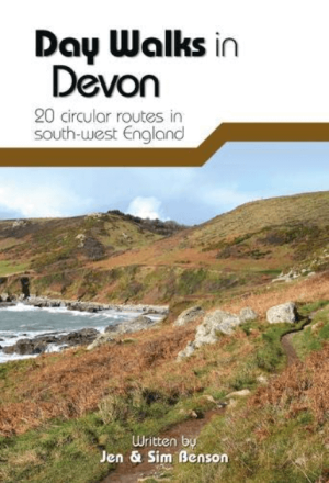
Wandelgids Day Walks in Devon - Vertebrate Publ. • 9781910240977
Day Walks in Devon - Vertebrate Productomschrijving: Day Walks in Devon features 20 circular routes, between 8.8 and 17.6 miles (14.1km and 28.3km), suitable for hillwalkers of all abilities. Local authors Jen and Sim Benson share their favourite walks in North Devon and Exmoor, Torridge and West Devon, Mid and East Devon, Dartmoor, and South Devon and the South Hams. The routes are s…

Wandelkaart 127 South Molton & Chulmleigh Devon England - OSI • 9780319470022
Wandelkaart South Molton & Chulmleigh - Devon England Omvat: King’s Nympton, Chittlehampton & Dolton. Productbeschrijving: Kaart nummer 127 in de OS Explorer kaarten reeks is ideaal om Noord-Devon te ontdekken. Dit gebied, net ten zuiden van Exmoor National Park, biedt prachtige landschappen en wandelingen onbedorven door het massa's. Andere hoogtepunten van het gebied zijn Chittlehamp…