

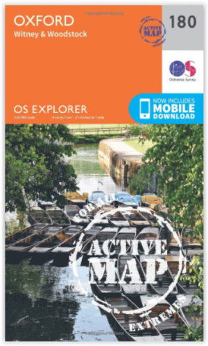
Wandelkaart 180 Oxford- England - OSI
Heeft betrekking op Oxford- Woodstock- Witney & Thame


Korte omschrijving
Wandelkaarten Oxfordshire west England van Ordnance Survey. Ideaal voor tochten in England.
Wandelkaart Oxford - England Omvat ook: Witney & Woodstock Productomschrijving: Kaart nummer 180 in de OS Explorer kaarten reeks heeft betrekking op Oxford, Woodstock, Witney, Thame, Kid...

Specificaties
- Uitgever: Ordnance Survey
- ISBN-13: 9780319243732
- HOOFDCATEGORIEËN: Wandelkaart
- Activiteiten: Wandelen, Hiking & Trekking
- Regio: Oxfordshire west England
- Land: England
- TOPO's & Stafkaarten: Topografisch wandelen
- Schaal: 1:25000
- Taal: Engels
- Reeks/Serie: Explorer Series OS
Volledige omschrijving
Wandelkaart Oxford - England
Omvat ook: Witney & Woodstock
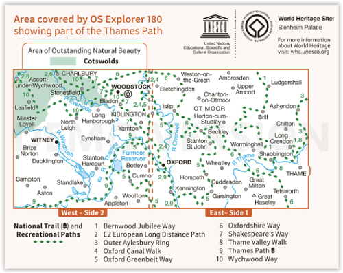
Productomschrijving: Kaart nummer 180 in de OS Explorer kaarten reeks heeft betrekking op Oxford, Woodstock, Witney, Thame, Kidlington en Ot Moor. Hoogtepunten zijn: de rivieren de Thame, Cherwell Windrush, de Zuid-west hoek van de Cotswolds AONB, een deel van het pad van de Thames, & het Oxford Canal Walk. De OS Explorer kaart voor Oxford is beschikbaar in zowel de standaard papieren versie als de weerbestendige 'Actief' versie
Kaart nummer 180 is een all purpose kaart vol gepakt met informatie om u het gebied te helpen leren kennen. De 204 Landranger-kaarten bestrijken het land. Elke kaart heeft een oppervlakte van 40 km door 40 km (25 mijl door 25 mijl) en zoals andere kaarten van Ordnance Survey, National Grid-vierkanten worden verstrekt zodat elke functie een unieke referentienummer kan worden gegeven.
Productdiscription: Map sheet number 180 in the OS Explorer series covers Oxford, Woodstock, Witney, Thame, Kidlington and Ot Moor. Highlights of the area include: rivers Thame, Evenlode, Cherwell and Windrush, the south west corner of the Cotswolds AONB, part of the Thames Path and the Oxford Canal Walk. The OS Explorer map for Oxford is available in both the standard paper version and weatherproof 'Active' version
Locatie op kaart
Gekoppelde artikelen

Wandelkaart 180 Oxford- England - OSI • 9780319243732
standaard versieWandelkaart Oxford - England Omvat ook: Witney & Woodstock Productomschrijving: Kaart nummer 180 in de OS Explorer kaarten reeks heeft betrekking op Oxford, Woodstock, Witney, Thame, Kidlington en Ot Moor. Hoogtepunten zijn: de rivieren de Thame, Cherwell Windrush, de Zuid-west hoek van de Cotswolds AONB, een deel van het pad van de Thames, & het Oxford Canal Walk. De OS Explorer kaart…
Wandelkaart 180 Oxford- Witney & Woodstock - OSI • 9780319470527
weatherproof versieWandelkaart Oxford- Witney & Woodstock - W. England Productbeschrijving: Kaart nummer 180 in de OS Explorer reeks heeft betrekking op Oxford, Woodstock, Witney, Thame, Kidlington en Ot Moor. Hoogtepunten zijn de rivieren Thame, Evenlode, Cherwell en Windrush, en de Zuid-west hoek van de Cotswolds AONB, deel van de "Thames pad" en het "Oxford Canal Walk". De OS Explorer kaart van Oxford is…
Overzichtskaarten

OSI Explorer & Explorer Active - Zuid England
OSI Explorer & Explorer Active - Zuid England

Producten op de overzichtskaart
Klik op een product om naar de detailpagina te gaan.
- Wandelkaart 117 Cerne Abbas & Bere Regis - Dorset - OSI
- Wandelkaart 118 Shaftesbury & Cranbourne Chase - OSI
- Wandelkaart 129 Yeovil & Sherborne - Somerset - OSI
- Wandelkaart 130 Salisburry & Stonehenge- Wiltshire - OSI
- Wandelkaart 131 Romsey & Andover - Hampshire - OSI
- Wandelkaart 135 Ashdown Forest - East Sussex - OSI
- Wandelkaart 141 Cheddar Gorge & Mendip Hills - OSI
- Wandelkaart 142 Shepton Mallet & Mendip Hills - OSI
- Wandelkaart 143 Warminster & Trowbridge - Wiltshire - OSI
- Wandelkaart 144 Basingstoke - Alton & Whitchurch - OSI
- Wandelkaart 145 Guildford & Farnham- Surrey - OSI
- Wandelkaart 146 Dorking- Box Hill & Reigate- Surrey - OSI
- Wandelkaart 147 Sevenoaks & Tonbridge- Kent - OSI
- Wandelkaart 154 Bristol West & Portishead- Bristol - OSI
- Wandelkaart 155 Bristol & Bath & Bristol Area - OSI
- Wandelkaart 156 Chippenham & Bradford-on-Avon - OSI
- Wandelkaart 157 Marlborough & Savernake Forest - OSI
- Wandelkaart 158 Newbury & Hungerford- Berkshire - OSI
- Wandelkaart 159 Reading- S.E. England - OSI
- Wandelkaart 160 Windsor- Weybridge & Bracknell - OSI
- Wandelkaart 161 London South - OSI
- Wandelkaart 162 Greenwich & Gravesend - OSI
- Wandelkaart 167 Thornbury- Dursley & Yate - England- OSI
- Wandelkaart 168 Stroud- Tetbury & Malmesbury - OSI
- Wandelkaart 169 Cirencester & Swindon - England - OSI
- Wandelkaart 170 Abingdon & Wantage - Oxfordshire - OSI
- Wandelkaart 171 Chiltern Hills West AONB - Wycombe - OSI
- Wandelkaart 172 Chiltern Hills East AONB - Wycombe - OSI
- Wandelkaart 173 London North- England - OSI
- Wandelkaart 174 Epping Forest & Lee Valley- Essex - OSI
- Wandelkaart 179 Gloucester- Cheltenham & Stroud - OSI
- Wandelkaart 180 Oxford- England - OSI
- Wandelkaart 181 Chiltern Hills North AONB- Wycombe - OSI
- Wandelkaart 182 St-Albans & Hatfield- Hertfordshire - OSI
- Wandelkaart OL03 Meon Valley Portsmouth - OS
- Wandelkaart OL08 Chichester- South Harting & Selsey - OS
- Wandelkaart OL10 Arundel- Pulborough & Worthing - OS
- Wandelkaart OL11 Brighton- Hove & South Downs NP - OS
- Wandelkaart OL22 New Forest National Park - OS
- Wandelkaart OL25 Eastbourne & Beachy Head - OS
- Wandelkaart OL29 Isle of Wight South East England - OS
- Wandelkaart OL32 Winchester, New Alresford & East Meon - OS
- Wandelkaart OL33 Haslemere & Petersfield - OS
- Wandelkaart OL34 Crawley & Horsham - Ordnance Survey

OSI Explorer & Explorer Active - Midden Engeland - Midlands
OSI Explorer & Explorer Active - Midden Engeland - Midlands

Producten op de overzichtskaart
Klik op een product om naar de detailpagina te gaan.
- Wandelkaart 180 Oxford- England - OSI
- Wandelkaart 181 Chiltern Hills North AONB- Wycombe - OSI
- Wandelkaart 182 St-Albans & Hatfield- Hertfordshire - OSI
- Wandelkaart 189 Hereford & Ross-on-Wye- England - OSI
- Wandelkaart 190 Malvern Hills AONB & Bredon Hill - OSI
- Wandelkaart 191 Banbury- Bicester & Chipping Norton- OSI
- Wandelkaart 192 Buckingham & Milton Keynes - OSI
- Wandelkaart 193 Luton & Stevenage- Bedfordshire - OSI
- Wandelkaart 194 Hertford & Bishop's Stortford - OSI
- Wandelkaart 202 Leominster & Bromyard Hererfordshire - OSI
- Wandelkaart 203 Ludlow & Shropshire Hills AONB - OSI
- Wandelkaart 204 Worcester & Droitwich Spa - OSI
- Wandelkaart 205 Stratford-upon-Avon & Evesham - OSI
- Wandelkaart 206 Edge Hill & Fenny Compton - OSI
- Wandelkaart 207 Newport Pagnell & Northampton - OSI
- Wandelkaart 208 Bedford & St Neots- Bedforeshire - OSI
- Wandelkaart 209 Cambridge - England - OSI
- Wandelkaart 217 Long Mynd & Wenlock Edge - OSI
- Wandelkaart 218 Kidderminster & Wyre Forest - OSI
- Wandelkaart 219 Wolverhampton & Dudley - OSI
- Wandelkaart 220 Birmingham- West Midlands - OSI
- Wandelkaart 221 Coventry & Warwickshire - OSI
- Wandelkaart 222 Rugby & Daventry- Warwickshire - OSI
- Wandelkaart 223 Northampton & Market Harborough - OSI
- Wandelkaart 224 Corby- Kettering & Wellingborough - OSI
- Wandelkaart 225 Huntingdon & St Ives - OSI
- Wandelkaart 227 Peterborough- Cambridgeshire England - OSI
- Wandelkaart 228 March- Ely- Chatteris & Littleport - OSI
- Wandelkaart 232 Nuneaton & Tamworth- Warwickshire - OSI
- Wandelkaart 233 Leicester & Hinckley England - OSI
- Wandelkaart 234 Rutland Water & Stamford- Oakham - OSI
- Wandelkaart 235 Wisbech & Peterborough North - OSI
- Wandelkaart 241 Shrewsbury- shropshire England - OSI
- Wandelkaart 242 Telford- Ironbridge & the Wrekin - OSI
- Wandelkaart 243 Market Drayton- Schropshire - OSI
- Wandelkaart 244 Cannock Chase & Chasewater- Severn - OSI
- Wandelkaart 245 National Forest- Burton-upon-Trent - OSI
- Wandelkaart 245 National Forest - OSI
- Wandelkaart 246 Loughborough- Leicestershire England - OSI
- Wandelkaart 247 Grantham- Lincolnshire - OSI
- Wandelkaart 248 Bourne & Heckington- lincolnshire - OSI
- Wandelkaart 249 Spalding & Holbeach- Lincolnshire - OSI
- Wandelkaart 257 Crewe & Nantwich & Cheshire East - OSI
- Wandelkaart 258 Stoke-on-Trent & Newcastle-under-Lyme- OSI
- Wandelkaart 259 Derby & Utoxeter- Derbyshire - OSI
- Wandelkaart 260 Nottingham & Vale of Belvoir - OSI
- Wandelkaart 261 Boston & Lincolnshire- England - OSI
- Wandelkaart 267 Northwich & Delamere Forest - OSI
- Wandelkaart 268 Wilmslow- Macclesfield & Congleton - OSI
- Wandelkaart 269 Chesterfield & Alfreton- Derbyshire- OSI
- Wandelkaart 270 Sherwood Forest- Nottinghamshire - OSI
- Wandelkaart 271 Newark-on-Trent- Nottinghampshire - OSI
- Wandelkaart 272 Lincoln- England - OSI
- Wandelkaart 273 Lincolnshire Wolds South- England - OSI
- Wandelkaart 274 Skegness- Alford & Spilsby - OSI
- Wandelkaart 275 Liverpool- South West England - OSI
- Wandelkaart 276 Bolton- Wigan & Warrington- Machester - OSI
- Wandelkaart 277 Manchester & Salford - OSI
- Wandelkaart 278 Sheffield & Barnsley- South Yorkshire - OSI
- Wandelkaart 279 Doncaster- South Yorkshire - OSI
- Wandelkaart 280 Isle of Axholme- Lincolnshire - OSI
- Wandelkaart 281 Ancholme Valley- Lincolnshire - OSI
- Wandelkaart 282 Lincolnshire Wolds North- England - OSI
- Wandelkaart 283 Louth & Mablethorpe- Lincolnshire - OSI
- Wandelkaart 284 Grimsby- Cleethorpes & Immingham - OSI
- Wandelkaart OL01 Peak District NP & Dark Peak area - OS
- Wandelkaart OL13 Brecon Beacons National Parc East - OS
- Wandelkaart OL24 Peak District & White Peak area - OS
- Wandelkaart OL40 The Broads National Park - OS

OSI Explorer & Explorer Active - Zuid Oost England - Kent & London
OSI Explorer & Explorer Active - Zuid Oost England - Kent & London

Producten op de overzichtskaart
Klik op een product om naar de detailpagina te gaan.
- Wandelkaart OL03 Meon Valley Portsmouth - OS
- Wandelkaart OL08 Chichester- South Harting & Selsey - OS
- Wandelkaart OL10 Arundel- Pulborough & Worthing - OS
- Wandelkaart OL11 Brighton- Hove & South Downs NP - OS
- Wandelkaart OL22 New Forest National Park - OS
- Wandelkaart OL25 Eastbourne & Beachy Head - OS
- Wandelkaart OL32 Winchester, New Alresford & East Meon - OS
- Wandelkaart OL29 Isle of Wight & Cowes - OSI
- Wandelkaart OL29 Isle of Wight South East England - OS
- Wandelkaart OL33 Haslemere & Petersfield - OS
- Wandelkaart OL33 Haslemere & Petersfield - OS
- Wandelkaart OL45 The Cotswolds AONB - OS
- Wandelkaart 118 Shaftesbury & Cranbourne Chase - OSI
- Wandelkaart 124 Hastings & Bexhill East Sussex - OSI
- Wandelkaart 124 Hastings & Bexhill East Sussex - OSI
- Wandelkaart 125 Romney Marsh Rye & Winchelsea - OSI
- Wandelkaart 130 Salisburry & Stonehenge- Wiltshire - OSI
- Wandelkaart 131 Romsey & Andover - Hampshire - OSI
- Wandelkaart 135 Ashdown Forest - East Sussex - OSI
- Wandelkaart 136 High Weald Royal Tunbridge Wells - OSI
- Wandelkaart 137 Ashford, Kent England - OSI
- Wandelkaart 138 Dover Folkstone & Hythe Kent - OSI
- Wandelkaart 144 Basingstoke - Alton & Whitchurch - OSI
- Wandelkaart 145 Guildford & Farnham- Surrey - OSI
- Wandelkaart 146 Dorking- Box Hill & Reigate- Surrey - OSI
- Wandelkaart 147 Sevenoaks & Tonbridge- Kent - OSI
- Wandelkaart 148 Maidstone & Medway Towns Kent - OSI
- Wandelkaart 149 Sittingbourne & Faversham- Kent - OSI
- Wandelkaart 150 Canterbury & Isle of Thanet- Kent - OSI
- Wandelkaart 157 Marlborough & Savernake Forest - OSI
- Wandelkaart 158 Newbury & Hungerford- Berkshire - OSI
- Wandelkaart 159 Reading- S.E. England - OSI
- Wandelkaart 160 Windsor- Weybridge & Bracknell - OSI
- Wandelkaart 161 London South - OSI
- Wandelkaart 162 Greenwich & Gravesend - OSI
- Wandelkaart 163 Gravesend & Rochester - OSI
- Wandelkaart 169 Cirencester & Swindon - England - OSI
- Wandelkaart 170 Abingdon & Wantage - Oxfordshire - OSI
- Wandelkaart 171 Chiltern Hills West AONB - Wycombe - OSI
- Wandelkaart 172 Chiltern Hills East AONB - Wycombe - OSI
- Wandelkaart 173 London North- England - OSI
- Wandelkaart 174 Epping Forest & Lee Valley- Essex - OSI
- Wandelkaart 175 Southend-on-Sea & Basildon Essex - OSI
- Wandelkaart 176 Blackwater Estuary- Essex- England - OSI
- Wandelkaart 180 Oxford- England - OSI
- Wandelkaart 181 Chiltern Hills North AONB- Wycombe - OSI
- Wandelkaart 182 St-Albans & Hatfield- Hertfordshire - OSI
- Wandelkaart 183 Chelmsford & the Rodings- Essex - OSI
- Wandelkaart 191 Banbury- Bicester & Chipping Norton- OSI
- Wandelkaart 192 Buckingham & Milton Keynes - OSI
- Wandelkaart 193 Luton & Stevenage- Bedfordshire - OSI
- Wandelkaart 194 Dorchester & Weymouth Dorset - OSI
- Wandelkaart 195 Braintree & Saffron Walden Essex - OSI
- Wandelkaart 196 Sudbury Hadleigh & Dedham Vale - OSI
- Wandelkaart 197 Ipswich Felixstowe & Harwich - OSI
- Wandelkaart 205 Stratford-upon-Avon & Evesham - OSI
- Wandelkaart 206 Edge Hill & Fenny Compton - OSI
- Wandelkaart 207 Newport Pagnell & Northampton - OSI
- Wandelkaart 208 Bedford & St Neots- Bedforeshire - OSI
- Wandelkaart 209 Cambridge - England - OSI
- Wandelkaart 210 Newmarket- Haverhill & Barrow - OSI
Artikelen uit dezelfde regio

Landkaart Wegenkaart Planning map Oxford & The Cotswolds • 9781788688499
Wegenkaart Planning map Oxford & The Cotswolds Productomschrijving: From Lonely Planet, the world's leading travel guide publisher Durable and waterproof, with a handy slipcase and an easy-fold format, Lonely Planet's Oxford & the Cotswolds Planning Map helps you get around with ease. Get more from your map and your trip with images and information about top attractions. - Durable and …

Cotswolds Mountain Biking - Vertebrate Publ. • 9781906148140
Cotswolds AONB Mountain Biking - Vertebrate Productomschrijving: 20 Classic Rides - Cotwolds Mountain Biking by Tom Fenton features 20 classic MTB routes in the Cotswold Hills across the counties of Gloucestershire and Oxfordshire, and extending into parts of Wiltshire, Somerset, Worcestershire and Warwickshire. With Ordnance Survey mapping and easy-to-follow directions. The Cotswold H…

Wandelgids - Cotswold classic walks guidebook - Goldeneye • 9781859652602
Wandelgids Cotswold classic walks guidebook Productomschrijving: In eerste instantie is dit wat de engelsen noemen een AONB, een "Area of Outstanding Natural Beauty" die in deze versie verspreidt word over verschillende regio's aangezien zijn grote. Deze plaats van subliem natuurschoon, ligt deel is, Somerset, deels in wawickshire, deels in Wiltshire, deels in Oxfordshire en is de meest be…

Wandelkaart 191 Banbury Bicester & Chipping Norton- OSI • 9780319470633
Wandelkaart Banbury- Bicester & Chipping Norton England Omvat ook: Brackley. Productbeschrijving: Kaart nummer 191 in de OS Explorer kaarten reeks heeft betrekking op een gedeelte van de Cotswolds en de Macmillan Way en Wychwood way recreatieve paden. Hoogtepunten van het gebied zijn de steden van Banbury, Chipping Norton, Brackley en Bicester, en de Oxford Canal Walk. De OS Explorer k…

Reisgids Cotswolds England - Rough Guides • 9780241308752
Reisgids Cotswolds England - Rough Guides Productomschrijving: The Rough Guide to the Cotswolds AONB is your definitive handbook to one of the most beautiful and diverse holiday destinations in the UK. From stately homes and wildlife parks to modern art galleries, country walks and adventure sports, there is a section that introduces all of the regions’ highlights. For every town and v…